![](/images/other/stat-length.png)
![Tour Wandern Saint-Plantaire - Le rocher de la Fileuse - Photo](https://media.geolcdn.com/t/1900/400/ext.pjpeg?maxdim=2&url=https%3A%2F%2Fstatic1.geolcdn.com%2Fsiteimages%2Fupload%2Ffiles%2F1553511878bg_sport_marche.png)
Le rocher de la Fileuse
Phil36
Benutzer
![Länge](/images/other/stat-length.png)
Länge
13,1 km
![Maximale Höhe](https://static1.geolcdn.com/siteimages/upload/files/1508320355ic_sort_altitude_max_24dp.png)
Maximale Höhe
295 m
![Positive Höhendifferenz](https://static1.geolcdn.com/siteimages/upload/files/1508320355ic_sort_den_pos_24dp.png)
Positive Höhendifferenz
273 m
![Km-Effort](/images/other/stat-length.png)
Km-Effort
16,7 km
![Min. Höhe](https://static1.geolcdn.com/siteimages/upload/files/1508320355ic_sort_altitude_min_24dp.png)
Min. Höhe
201 m
![Negative Höhendifferenz](https://static1.geolcdn.com/siteimages/upload/files/1508320355ic_sort_den_neg_24dp.png)
Negative Höhendifferenz
271 m
![Boucle](https://static1.geolcdn.com/siteimages/upload/files/16400158638029165_repeat_loop_refresh_sync_direction_icon.png)
Boucle
Ja
Erstellungsdatum :
2022-10-08 05:04:06.156
Letzte Änderung :
2022-10-08 05:07:30.021
![Wandern](https://static1.geolcdn.com/sitytour/trail-icons/101.png)
3h48
Schwierigkeit : Schwierig
![Scannen Sie diesen QR-Code, um die Tour in der SityTrail-Anwendung zu öffnen](https://capi.geolives.com/qq0zvz2zws4bq2lad0pu/sitytour/trails/3416344/qr.png?size=200)
Kostenlosegpshiking-Anwendung
Über SityTrail
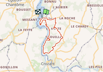
Tour Wandern von 13,1 km verfügbar auf Zentrum-Loiretal, Indre, Saint-Plantaire. Diese Tour wird von Phil36 vorgeschlagen.
Beschreibung
De Fougères aux ruines de Crozant, ce parcours est un enchantement pour découvrir les multiples facettes de la vallée de la Creuse.
Ort
Land:
France
Region :
Zentrum-Loiretal
Abteilung/Provinz :
Indre
Kommune :
Saint-Plantaire
Standort:
Unknown
Gehen Sie:(Dec)
Gehen Sie:(UTM)
393588 ; 5142648 (31T) N.
Kommentare
Touren in der Umgebung
![Tour Wandern Éguzon-Chantôme - SityTrail - eguzon,la Feyte barrage d'eguzon - Photo](https://media.geolcdn.com/t/375/260/ext.jpg?maxdim=2&url=https%3A%2F%2Fstatic1.geolcdn.com%2Fsiteimages%2Fupload%2Ffiles%2F1553511878bg_sport_marche.png)
![Wandern Wandern](https://static1.geolcdn.com/sitytour/trail-icons/101.png)
SityTrail - eguzon,la Feyte barrage d'eguzon
Wandern
Sehr schwierig
(1)
Éguzon-Chantôme,
Zentrum-Loiretal,
Indre,
France
![](/images/other/stat-length.png)
18,5 km | 24 km-effort
5h 26min
![](https://static1.geolcdn.com/siteimages/upload/files/16400158638029165_repeat_loop_refresh_sync_direction_icon.png)
Ja
![Tour Wandern Crozant - SityTrail - Crozant Fresselines - Photo](https://media.geolcdn.com/t/375/260/ext.jpg?maxdim=2&url=https%3A%2F%2Fstatic1.geolcdn.com%2Fsiteimages%2Fupload%2Ffiles%2F1553511878bg_sport_marche.png)
![Wandern Wandern](https://static1.geolcdn.com/sitytour/trail-icons/101.png)
SityTrail - Crozant Fresselines
Wandern
Sehr schwierig
(1)
Crozant,
Neu-Aquitanien,
Creuse,
France
![](/images/other/stat-length.png)
18 km | 25 km-effort
5h 41min
![](https://static1.geolcdn.com/siteimages/upload/files/16400158638029165_repeat_loop_refresh_sync_direction_icon.png)
Ja
![Tour Wandern Saint-Plantaire - SityTrail - Fougères Rochers de la Fileuse sentier des arts - Photo](https://media.geolcdn.com/t/375/260/ext.jpg?maxdim=2&url=https%3A%2F%2Fstatic1.geolcdn.com%2Fsiteimages%2Fupload%2Ffiles%2F1553511878bg_sport_marche.png)
![Wandern Wandern](https://static1.geolcdn.com/sitytour/trail-icons/101.png)
SityTrail - Fougères Rochers de la Fileuse sentier des arts
Wandern
Sehr schwierig
(1)
Saint-Plantaire,
Zentrum-Loiretal,
Indre,
France
![](/images/other/stat-length.png)
17,3 km | 22 km-effort
5h 6min
![](https://static1.geolcdn.com/siteimages/upload/files/16400158638029165_repeat_loop_refresh_sync_direction_icon.png)
Ja
![Tour Wandern Saint-Plantaire - le rocher de la fileuse - Photo](https://media.geolcdn.com/t/375/260/ext.jpg?maxdim=2&url=https%3A%2F%2Fmedia.geolcdn.com%2Ff%2F63e01f3b-2c40-4abe-b316-e6aba79cad32.jpg)
![Wandern Wandern](https://static1.geolcdn.com/sitytour/trail-icons/101.png)
le rocher de la fileuse
Wandern
Medium
(1)
Saint-Plantaire,
Zentrum-Loiretal,
Indre,
France
![](/images/other/stat-length.png)
15 km | 19,4 km-effort
6h 7min
![](https://static1.geolcdn.com/siteimages/upload/files/16400158638029165_repeat_loop_refresh_sync_direction_icon.png)
Ja
![Tour Wandern Cuzion - Pont des Piles - Crozant - Photo](https://media.geolcdn.com/t/375/260/ext.jpg?maxdim=2&url=https%3A%2F%2Fservices.sitytrail.com%2FGeolivesWS%2FDownloadMedia.ashx%3FTrailID%3D129658%26Media%3D13186_4.jpg)
![Wandern Wandern](https://static1.geolcdn.com/sitytour/trail-icons/101.png)
Pont des Piles - Crozant
Wandern
Medium
Cuzion,
Zentrum-Loiretal,
Indre,
France
![](/images/other/stat-length.png)
29 km | 38 km-effort
7h 0min
![](https://static1.geolcdn.com/siteimages/upload/files/16400158638029165_repeat_loop_refresh_sync_direction_icon.png)
Ja
![Tour Wandern Cuzion - la passerelle de casse cou - Photo](https://media.geolcdn.com/t/375/260/ext.jpg?maxdim=2&url=https%3A%2F%2Fmedia.geolcdn.com%2Ff%2F98273f83-f83d-4b56-b57b-cbcbe74e1018.jpg)
![Wandern Wandern](https://static1.geolcdn.com/sitytour/trail-icons/101.png)
la passerelle de casse cou
Wandern
Einfach
Cuzion,
Zentrum-Loiretal,
Indre,
France
![](/images/other/stat-length.png)
3,2 km | 4,3 km-effort
1h 10min
![](https://static1.geolcdn.com/siteimages/upload/files/16400158638029165_repeat_loop_refresh_sync_direction_icon.png)
Ja
![Tour Wandern Crozant - boucle crozant-fresselines - Photo](https://media.geolcdn.com/t/375/260/ext.jpg?maxdim=2&url=https%3A%2F%2Fmedia.geolcdn.com%2Ff%2Fdfc2296d-7db6-49ca-b686-bfbc82332e76.jpg)
![Wandern Wandern](https://static1.geolcdn.com/sitytour/trail-icons/101.png)
boucle crozant-fresselines
Wandern
Schwierig
Crozant,
Neu-Aquitanien,
Creuse,
France
![](/images/other/stat-length.png)
20 km | 27 km-effort
6h 22min
![](https://static1.geolcdn.com/siteimages/upload/files/16400158638029165_repeat_loop_refresh_sync_direction_icon.png)
Ja
![Tour Wandern Crozant - Crozant la vallée des peintres - Photo](https://media.geolcdn.com/t/375/260/ext.jpg?maxdim=2&url=https%3A%2F%2Fmedia.geolcdn.com%2Ff%2F3c15fdf1-6872-4e02-82f3-d8297089ab1f.jpg)
![Wandern Wandern](https://static1.geolcdn.com/sitytour/trail-icons/101.png)
Crozant la vallée des peintres
Wandern
Einfach
Crozant,
Neu-Aquitanien,
Creuse,
France
![](/images/other/stat-length.png)
4,4 km | 5,4 km-effort
2h 21min
![](https://static1.geolcdn.com/siteimages/upload/files/16400158638029165_repeat_loop_refresh_sync_direction_icon.png)
Ja
![Tour Wandern Éguzon-Chantôme - 5 ème rando Eguzon 18 km - Photo](https://media.geolcdn.com/t/375/260/ext.jpg?maxdim=2&url=https%3A%2F%2Fmedia.geolcdn.com%2Ff%2F5c05fb44-3c5c-4136-a323-043f035ea6e4.jpg)
![Wandern Wandern](https://static1.geolcdn.com/sitytour/trail-icons/101.png)
5 ème rando Eguzon 18 km
Wandern
Sehr schwierig
Éguzon-Chantôme,
Zentrum-Loiretal,
Indre,
France
![](/images/other/stat-length.png)
19,9 km | 25 km-effort
4h 55min
![](https://static1.geolcdn.com/siteimages/upload/files/16400158638029165_repeat_loop_refresh_sync_direction_icon.png)
Nein