![](/images/other/stat-length.png)
![Tour Wandern Saint-Sernin-du-Bois - reco 16 octobre 2022 - Photo](https://media.geolcdn.com/t/1900/400/ext.pjpeg?maxdim=2&url=https%3A%2F%2Fstatic1.geolcdn.com%2Fsiteimages%2Fupload%2Ffiles%2F1553511878bg_sport_marche.png)
reco 16 octobre 2022
Gilbert bro
Benutzer
![Länge](/images/other/stat-length.png)
Länge
9,3 km
![Maximale Höhe](https://static1.geolcdn.com/siteimages/upload/files/1508320355ic_sort_altitude_max_24dp.png)
Maximale Höhe
538 m
![Positive Höhendifferenz](https://static1.geolcdn.com/siteimages/upload/files/1508320355ic_sort_den_pos_24dp.png)
Positive Höhendifferenz
145 m
![Km-Effort](/images/other/stat-length.png)
Km-Effort
11,3 km
![Min. Höhe](https://static1.geolcdn.com/siteimages/upload/files/1508320355ic_sort_altitude_min_24dp.png)
Min. Höhe
436 m
![Negative Höhendifferenz](https://static1.geolcdn.com/siteimages/upload/files/1508320355ic_sort_den_neg_24dp.png)
Negative Höhendifferenz
149 m
![Boucle](https://static1.geolcdn.com/siteimages/upload/files/16400158638029165_repeat_loop_refresh_sync_direction_icon.png)
Boucle
Ja
Erstellungsdatum :
2022-10-05 07:06:16.228
Letzte Änderung :
2022-10-05 10:20:39.261
![Wandern](https://static1.geolcdn.com/sitytour/trail-icons/101.png)
3h13
Schwierigkeit : Medium
![Scannen Sie diesen QR-Code, um die Tour in der SityTrail-Anwendung zu öffnen](https://capi.geolives.com/qq0zvz2zws4bq2lad0pu/sitytour/trails/3413471/qr.png?size=200)
Kostenlosegpshiking-Anwendung
Über SityTrail
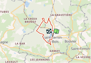
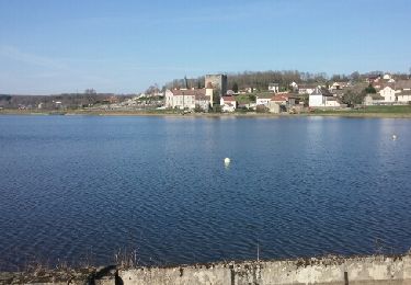
Tour Wandern von 9,3 km verfügbar auf Burgund und Freigrafschaft, Saône-et-Loire, Saint-Sernin-du-Bois. Diese Tour wird von Gilbert bro vorgeschlagen.
Beschreibung
la tour de St Sernin, la Borne Creuse, la Pissoire, sommiere du Moy, APN, Bois Courant, la digue
Ort
Land:
France
Region :
Burgund und Freigrafschaft
Abteilung/Provinz :
Saône-et-Loire
Kommune :
Saint-Sernin-du-Bois
Standort:
Unknown
Gehen Sie:(Dec)
Gehen Sie:(UTM)
609280 ; 5188512 (31T) N.
Kommentare
Touren in der Umgebung
![Tour Wandern Saint-Sernin-du-Bois - Saint Sernin du bois - Photo](https://media.geolcdn.com/t/375/260/ext.jpg?maxdim=2&url=https%3A%2F%2Fservices.sitytrail.com%2FGeolivesWS%2FDownloadMedia.ashx%3FTrailID%3D405966%26Media%3Dfix__20150409172617.jpg)
![Wandern Wandern](https://static1.geolcdn.com/sitytour/trail-icons/101.png)
Saint Sernin du bois
Wandern
Medium
Saint-Sernin-du-Bois,
Burgund und Freigrafschaft,
Saône-et-Loire,
France
![](/images/other/stat-length.png)
11,1 km | 13,1 km-effort
2h 52min
![](https://static1.geolcdn.com/siteimages/upload/files/16400158638029165_repeat_loop_refresh_sync_direction_icon.png)
Ja
![Tour Mountainbike Le Creusot - le Creusot Blanzy st Jean de trezy - Photo](https://media.geolcdn.com/t/375/260/ext.jpg?maxdim=2&url=https%3A%2F%2Fstatic1.geolcdn.com%2Fsiteimages%2Fupload%2Ffiles%2F1524743154velo.jpg)
![Mountainbike Mountainbike](https://static1.geolcdn.com/sitytour/trail-icons/202.png)
le Creusot Blanzy st Jean de trezy
Mountainbike
Medium
Le Creusot,
Burgund und Freigrafschaft,
Saône-et-Loire,
France
![](/images/other/stat-length.png)
61 km | 73 km-effort
3h 25min
![](https://static1.geolcdn.com/siteimages/upload/files/16400158638029165_repeat_loop_refresh_sync_direction_icon.png)
Ja
![Tour Elektrofahrrad Le Creusot - le Creusot la celle d en bas 41km700 - Photo](https://media.geolcdn.com/t/375/260/ext.jpg?maxdim=2&url=https%3A%2F%2Fstatic1.geolcdn.com%2Fsiteimages%2Fupload%2Ffiles%2F1524743154velo.jpg)
![Elektrofahrrad Elektrofahrrad](https://static1.geolcdn.com/sitytour/trail-icons/205.png)
le Creusot la celle d en bas 41km700
Elektrofahrrad
Einfach
Le Creusot,
Burgund und Freigrafschaft,
Saône-et-Loire,
France
![](/images/other/stat-length.png)
51 km | 63 km-effort
2h 37min
![](https://static1.geolcdn.com/siteimages/upload/files/16400158638029165_repeat_loop_refresh_sync_direction_icon.png)
Ja
![Tour Wandern Le Creusot - Les Combes reco - Photo](https://media.geolcdn.com/t/375/260/ext.jpg?maxdim=2&url=https%3A%2F%2Fstatic1.geolcdn.com%2Fsiteimages%2Fupload%2Ffiles%2F1553511878bg_sport_marche.png)
![Wandern Wandern](https://static1.geolcdn.com/sitytour/trail-icons/101.png)
Les Combes reco
Wandern
Einfach
Le Creusot,
Burgund und Freigrafschaft,
Saône-et-Loire,
France
![](/images/other/stat-length.png)
6 km | 7,5 km-effort
1h 42min
![](https://static1.geolcdn.com/siteimages/upload/files/16400158638029165_repeat_loop_refresh_sync_direction_icon.png)
Ja
![Tour Wandern Le Creusot - le creusot moi pierre 23 11 2023 n°6 - Photo](https://media.geolcdn.com/t/375/260/ext.jpg?maxdim=2&url=https%3A%2F%2Fstatic1.geolcdn.com%2Fsiteimages%2Fupload%2Ffiles%2F1553511878bg_sport_marche.png)
![Wandern Wandern](https://static1.geolcdn.com/sitytour/trail-icons/101.png)
le creusot moi pierre 23 11 2023 n°6
Wandern
Schwierig
Le Creusot,
Burgund und Freigrafschaft,
Saône-et-Loire,
France
![](/images/other/stat-length.png)
9,5 km | 13,3 km-effort
3h 1min
![](https://static1.geolcdn.com/siteimages/upload/files/16400158638029165_repeat_loop_refresh_sync_direction_icon.png)
Ja
![Tour Wandern Le Creusot - le creusot macdo 5 23 11 2023 moi pierre - Photo](https://media.geolcdn.com/t/375/260/ext.jpg?maxdim=2&url=https%3A%2F%2Fstatic1.geolcdn.com%2Fsiteimages%2Fupload%2Ffiles%2F1553511878bg_sport_marche.png)
![Wandern Wandern](https://static1.geolcdn.com/sitytour/trail-icons/101.png)
le creusot macdo 5 23 11 2023 moi pierre
Wandern
Schwierig
Le Creusot,
Burgund und Freigrafschaft,
Saône-et-Loire,
France
![](/images/other/stat-length.png)
9,5 km | 13,3 km-effort
3h 0min
![](https://static1.geolcdn.com/siteimages/upload/files/16400158638029165_repeat_loop_refresh_sync_direction_icon.png)
Ja
![Tour Wandern Le Creusot - Extrait du T3C du creusot - Photo](https://media.geolcdn.com/t/375/260/ext.jpg?maxdim=2&url=https%3A%2F%2Fstatic1.geolcdn.com%2Fsiteimages%2Fupload%2Ffiles%2F1553511878bg_sport_marche.png)
![Wandern Wandern](https://static1.geolcdn.com/sitytour/trail-icons/101.png)
Extrait du T3C du creusot
Wandern
Sehr schwierig
Le Creusot,
Burgund und Freigrafschaft,
Saône-et-Loire,
France
![](/images/other/stat-length.png)
18,7 km | 27 km-effort
5h 9min
![](https://static1.geolcdn.com/siteimages/upload/files/16400158638029165_repeat_loop_refresh_sync_direction_icon.png)
Ja
![Tour Nordic Walking Le Creusot - M-N Les Combes Bois de la chaume 8km - Photo](https://media.geolcdn.com/t/375/260/ext.jpg?maxdim=2&url=https%3A%2F%2Fstatic1.geolcdn.com%2Fsiteimages%2Fupload%2Ffiles%2F1545311037marcheuse_200dpi.jpg)
![Nordic Walking Nordic Walking](https://static1.geolcdn.com/sitytour/trail-icons/102.png)
M-N Les Combes Bois de la chaume 8km
Nordic Walking
Sehr leicht
Le Creusot,
Burgund und Freigrafschaft,
Saône-et-Loire,
France
![](/images/other/stat-length.png)
7,8 km | 10,4 km-effort
Unbekannt
![](https://static1.geolcdn.com/siteimages/upload/files/16400158638029165_repeat_loop_refresh_sync_direction_icon.png)
Ja
![Tour Wandern Le Breuil - marche au breuil - Photo](https://media.geolcdn.com/t/375/260/ext.jpg?maxdim=2&url=https%3A%2F%2Fstatic1.geolcdn.com%2Fsiteimages%2Fupload%2Ffiles%2F1553511878bg_sport_marche.png)
![Wandern Wandern](https://static1.geolcdn.com/sitytour/trail-icons/101.png)
marche au breuil
Wandern
Schwierig
Le Breuil,
Burgund und Freigrafschaft,
Saône-et-Loire,
France
![](/images/other/stat-length.png)
10,3 km | 12,4 km-effort
2h 49min
![](https://static1.geolcdn.com/siteimages/upload/files/16400158638029165_repeat_loop_refresh_sync_direction_icon.png)
Ja