![](/images/other/stat-length.png)
![Tour Wandern Seraing - Bois de la Vecquee - Seraing - Photo](https://media.geolcdn.com/t/1900/400/ext.pjpeg?maxdim=2&url=https%3A%2F%2Fstatic1.geolcdn.com%2Fsiteimages%2Fupload%2Ffiles%2F1553511878bg_sport_marche.png)
Bois de la Vecquee - Seraing
estellecharlier
Benutzer
![Länge](/images/other/stat-length.png)
Länge
5,1 km
![Maximale Höhe](https://static1.geolcdn.com/siteimages/upload/files/1508320355ic_sort_altitude_max_24dp.png)
Maximale Höhe
275 m
![Positive Höhendifferenz](https://static1.geolcdn.com/siteimages/upload/files/1508320355ic_sort_den_pos_24dp.png)
Positive Höhendifferenz
55 m
![Km-Effort](/images/other/stat-length.png)
Km-Effort
5,8 km
![Min. Höhe](https://static1.geolcdn.com/siteimages/upload/files/1508320355ic_sort_altitude_min_24dp.png)
Min. Höhe
249 m
![Negative Höhendifferenz](https://static1.geolcdn.com/siteimages/upload/files/1508320355ic_sort_den_neg_24dp.png)
Negative Höhendifferenz
54 m
![Boucle](https://static1.geolcdn.com/siteimages/upload/files/16400158638029165_repeat_loop_refresh_sync_direction_icon.png)
Boucle
Ja
Erstellungsdatum :
2022-10-01 07:56:48.163
Letzte Änderung :
2022-10-01 09:30:33.662
![Wandern](https://static1.geolcdn.com/sitytour/trail-icons/101.png)
1h13
Schwierigkeit : Einfach
![Scannen Sie diesen QR-Code, um die Tour in der SityTrail-Anwendung zu öffnen](https://capi.geolives.com/qq0zvz2zws4bq2lad0pu/sitytour/trails/3409136/qr.png?size=200)
Kostenlosegpshiking-Anwendung
Über SityTrail
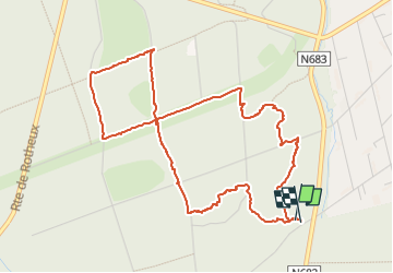
Tour Wandern von 5,1 km verfügbar auf Wallonien, Lüttich, Seraing. Diese Tour wird von estellecharlier vorgeschlagen.
Beschreibung
Attention au début un passage hors sentier dans les bois. Il y avait l'air d'avoir un chemin mais celui-ci s'arrête au milieu du bois. Pour éviter ça, vous pouvez prendre le chemin plus loin à gauche.
Ort
Land:
Belgium
Region :
Wallonien
Abteilung/Provinz :
Lüttich
Kommune :
Seraing
Standort:
Unknown
Gehen Sie:(Dec)
Gehen Sie:(UTM)
678671 ; 5603944 (31U) N.
Kommentare
Touren in der Umgebung
![Tour Wandern Esneux - Esneux bois du mary - Photo](https://media.geolcdn.com/t/375/260/71c77441-f9b7-4220-bb0a-fbf9c3317653.jpg&format=jpg&maxdim=2)
![Wandern Wandern](https://static1.geolcdn.com/sitytour/trail-icons/101.png)
Esneux bois du mary
Wandern
Einfach
(5)
Esneux,
Wallonien,
Lüttich,
Belgium
![](/images/other/stat-length.png)
4,4 km | 5,9 km-effort
1h 11min
![](https://static1.geolcdn.com/siteimages/upload/files/16400158638029165_repeat_loop_refresh_sync_direction_icon.png)
Ja
![Tour Wandern Esneux - RB-Lg-20_Tilff - Photo](https://media.geolcdn.com/t/375/260/ext.jpg?maxdim=2&url=https%3A%2F%2Fservices.sitytrail.com%2FGeolivesWS%2FDownloadMedia.ashx%3FTrailID%3D400739%26Media%3D2cb4df8e-af53-4650-9797-54389fe3086f.jpg)
![Wandern Wandern](https://static1.geolcdn.com/sitytour/trail-icons/101.png)
RB-Lg-20_Tilff
Wandern
Sehr schwierig
(7)
Esneux,
Wallonien,
Lüttich,
Belgium
![](/images/other/stat-length.png)
20 km | 28 km-effort
6h 21min
![](https://static1.geolcdn.com/siteimages/upload/files/16400158638029165_repeat_loop_refresh_sync_direction_icon.png)
Ja
![Tour Wandern Neupré - Neupré - liaisons inter-hameaux et -villages - Photo](https://media.geolcdn.com/t/375/260/ext.jpg?maxdim=2&url=https%3A%2F%2Fservices.sitytrail.com%2FGeolivesWS%2FDownloadMedia.ashx%3FTrailID%3D347446%26Media%3Dfix__20140903123425.jpg)
![Wandern Wandern](https://static1.geolcdn.com/sitytour/trail-icons/101.png)
Neupré - liaisons inter-hameaux et -villages
Wandern
Medium
(13)
Neupré,
Wallonien,
Lüttich,
Belgium
![](/images/other/stat-length.png)
10,8 km | 14,1 km-effort
2h 59min
![](https://static1.geolcdn.com/siteimages/upload/files/16400158638029165_repeat_loop_refresh_sync_direction_icon.png)
Ja
![Tour Wandern Neupré - Neupré - les contreforts de la Boucle de l'Ourthe - Photo](https://media.geolcdn.com/t/375/260/ext.jpg?maxdim=2&url=https%3A%2F%2Fservices.sitytrail.com%2FGeolivesWS%2FDownloadMedia.ashx%3FTrailID%3D347434%26Media%3Dfix__20140909180027.jpg)
![Wandern Wandern](https://static1.geolcdn.com/sitytour/trail-icons/101.png)
Neupré - les contreforts de la Boucle de l'Ourthe
Wandern
Medium
(18)
Neupré,
Wallonien,
Lüttich,
Belgium
![](/images/other/stat-length.png)
7,9 km | 10,9 km-effort
2h 21min
![](https://static1.geolcdn.com/siteimages/upload/files/16400158638029165_repeat_loop_refresh_sync_direction_icon.png)
Ja
![Tour Wandern Esneux - RB-LG-10 - Raccourci - Photo](https://media.geolcdn.com/t/375/260/ext.jpg?maxdim=2&url=https%3A%2F%2Fservices.sitytrail.com%2FGeolivesWS%2FDownloadMedia.ashx%3FTrailID%3D209422%26Media%3D464c3dd7-df43-4893-8019-c771f2bd17f1.jpg)
![Wandern Wandern](https://static1.geolcdn.com/sitytour/trail-icons/101.png)
RB-LG-10 - Raccourci
Wandern
Schwierig
(7)
Esneux,
Wallonien,
Lüttich,
Belgium
![](/images/other/stat-length.png)
11 km | 15,1 km-effort
3h 26min
![](https://static1.geolcdn.com/siteimages/upload/files/16400158638029165_repeat_loop_refresh_sync_direction_icon.png)
Ja
![Tour Wandern Esneux - RB-LG-10 - Au fil de l’Ourthe : la boucle de Fêchereux et au-delà - Photo](https://media.geolcdn.com/t/375/260/ext.jpg?maxdim=2&url=https%3A%2F%2Fservices.sitytrail.com%2FGeolivesWS%2FDownloadMedia.ashx%3FTrailID%3D179568%26Media%3D18c2b0fe-ccb1-462d-9e89-f89259226c52.jpg)
![Wandern Wandern](https://static1.geolcdn.com/sitytour/trail-icons/101.png)
RB-LG-10 - Au fil de l’Ourthe : la boucle de Fêchereux et au-delà
Wandern
Sehr schwierig
(21)
Esneux,
Wallonien,
Lüttich,
Belgium
![](/images/other/stat-length.png)
21 km | 29 km-effort
6h 32min
![](https://static1.geolcdn.com/siteimages/upload/files/16400158638029165_repeat_loop_refresh_sync_direction_icon.png)
Ja
![Tour Wandern Neupré - Neupré - balade de Rotheux - Photo](https://media.geolcdn.com/t/375/260/ext.jpg?maxdim=2&url=https%3A%2F%2Fservices.sitytrail.com%2FGeolivesWS%2FDownloadMedia.ashx%3FTrailID%3D347399%26Media%3D32c01f91-c180-4d53-8d7d-a74522876cd8.JPG)
![Wandern Wandern](https://static1.geolcdn.com/sitytour/trail-icons/101.png)
Neupré - balade de Rotheux
Wandern
Medium
(11)
Neupré,
Wallonien,
Lüttich,
Belgium
![](/images/other/stat-length.png)
8,7 km | 11,1 km-effort
2h 21min
![](https://static1.geolcdn.com/siteimages/upload/files/16400158638029165_repeat_loop_refresh_sync_direction_icon.png)
Ja
![Tour Wandern Neupré - Neupré - Sentier Paysage et Géologie - Photo](https://media.geolcdn.com/t/375/260/ext.jpg?maxdim=2&url=https%3A%2F%2Fservices.sitytrail.com%2FGeolivesWS%2FDownloadMedia.ashx%3FTrailID%3D343711%26Media%3Dfix__20140909182657.jpg)
![Wandern Wandern](https://static1.geolcdn.com/sitytour/trail-icons/101.png)
Neupré - Sentier Paysage et Géologie
Wandern
Einfach
(9)
Neupré,
Wallonien,
Lüttich,
Belgium
![](/images/other/stat-length.png)
2,7 km | 3,6 km-effort
50min
![](https://static1.geolcdn.com/siteimages/upload/files/16400158638029165_repeat_loop_refresh_sync_direction_icon.png)
Ja
![Tour Wandern Neupré - Neupré - Balade du Chemin des morts - Photo](https://media.geolcdn.com/t/375/260/ext.jpg?maxdim=2&url=https%3A%2F%2Fstatic1.geolcdn.com%2Fsiteimages%2Fupload%2Ffiles%2F1553511878bg_sport_marche.png)
![Wandern Wandern](https://static1.geolcdn.com/sitytour/trail-icons/101.png)
Neupré - Balade du Chemin des morts
Wandern
Medium
(15)
Neupré,
Wallonien,
Lüttich,
Belgium
![](/images/other/stat-length.png)
5,1 km | 7,4 km-effort
1h 33min
![](https://static1.geolcdn.com/siteimages/upload/files/16400158638029165_repeat_loop_refresh_sync_direction_icon.png)
Ja