![](/images/other/stat-length.png)
![Tour Wandern Clerf - 2022-09-22_13h18m05_t62883822_eislek pad heinerscheid - Photo](https://media.geolcdn.com/t/1900/400/ext.pjpeg?maxdim=2&url=https%3A%2F%2Fstatic1.geolcdn.com%2Fsiteimages%2Fupload%2Ffiles%2F1553511878bg_sport_marche.png)
2022-09-22_13h18m05_t62883822_eislek pad heinerscheid
mumu.larandonneuse
Benutzer GUIDE
![Länge](/images/other/stat-length.png)
![Maximale Höhe](https://static1.geolcdn.com/siteimages/upload/files/1508320355ic_sort_altitude_max_24dp.png)
![Positive Höhendifferenz](https://static1.geolcdn.com/siteimages/upload/files/1508320355ic_sort_den_pos_24dp.png)
![Km-Effort](/images/other/stat-length.png)
![Min. Höhe](https://static1.geolcdn.com/siteimages/upload/files/1508320355ic_sort_altitude_min_24dp.png)
![Negative Höhendifferenz](https://static1.geolcdn.com/siteimages/upload/files/1508320355ic_sort_den_neg_24dp.png)
![Boucle](https://static1.geolcdn.com/siteimages/upload/files/16400158638029165_repeat_loop_refresh_sync_direction_icon.png)
![Wandern](https://static1.geolcdn.com/sitytour/trail-icons/101.png)
5h02
Schwierigkeit : Medium
![Scannen Sie diesen QR-Code, um die Tour in der SityTrail-Anwendung zu öffnen](https://capi.geolives.com/qq0zvz2zws4bq2lad0pu/sitytour/trails/3399968/qr.png?size=200)
Kostenlosegpshiking-Anwendung
Über SityTrail
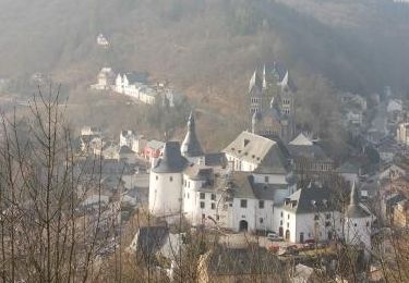
Tour Wandern von 15,8 km verfügbar auf Unbekannt, Kanton Clerf, Clerf. Diese Tour wird von mumu.larandonneuse vorgeschlagen.
Beschreibung
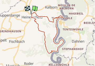
Éislek Pad Heinerscheid
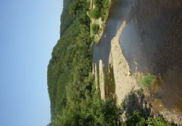
Vers la vallée profonde
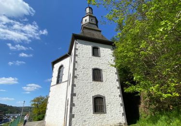
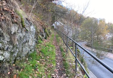
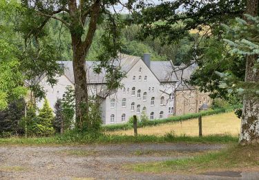
Votre chemin commence au sommet de Heinerscheid. Arrêtez-vous un instant devant le monument de la 6th Armored Division. Puis, pas à pas, vous descendez dans la vallée de l'Our. Avant de descendre complètement, vous traverserez une crête rocheuse abrupte, la Kasselslee. De là, vous pourrez apercevoir pour la première fois la rivière qui vous accompagnera tout le reste du chemin. La montée vers le point de vue Kailslee vous fait sortir de la vallée.
Départ : Parking à la sortie du village, Hepperdangerstrooss, Heinerscheid
Arrivée : Parking à la sortie du village, Hepperdangerstrooss, Heinerscheid
Distance : 15,843 km
Altitude : 528 m
Temps : 04h50
ℹ sur www.visit-eislek.lu
Ort
Kommentare
Touren in der Umgebung
![Tour Wandern Clerf - 2023-09-06_11h37m03_sentier-local-cl-5 - Photo](https://media.geolcdn.com/t/375/260/4d9c17af-90bd-4623-96d9-f2a288b490ef.jpg&format=jpg&maxdim=2)
![Wandern Wandern](https://static1.geolcdn.com/sitytour/trail-icons/101.png)
Wandern
![](/images/other/stat-length.png)
![](https://static1.geolcdn.com/siteimages/upload/files/16400158638029165_repeat_loop_refresh_sync_direction_icon.png)
![Tour Wandern Clerf - 2023-09-06_11h14m49_sentier-local-cl-2 - Photo](https://media.geolcdn.com/t/375/260/378df12a-c7ca-4826-9832-7c942624e739.jpg&format=jpg&maxdim=2)
![Wandern Wandern](https://static1.geolcdn.com/sitytour/trail-icons/101.png)
Wandern
![](/images/other/stat-length.png)
![](https://static1.geolcdn.com/siteimages/upload/files/16400158638029165_repeat_loop_refresh_sync_direction_icon.png)
![Tour Wandern Burg-Reuland - Ouren - Natura 2000 – Gebiete, die einen Besuch wert sind - Photo](https://media.geolcdn.com/t/375/260/ext.jpg?maxdim=2&url=https%3A%2F%2Fservices.sitytrail.com%2FGeolivesWS%2FDownloadMedia.ashx%3FTrailID%3D322212%26Media%3D6bbceaa3-bfa3-42bc-a6d6-8c51408cfb44.JPG)
![Wandern Wandern](https://static1.geolcdn.com/sitytour/trail-icons/101.png)
Wandern
![](/images/other/stat-length.png)
![](https://static1.geolcdn.com/siteimages/upload/files/16400158638029165_repeat_loop_refresh_sync_direction_icon.png)
![Tour Wandern Clerf - Eislek Pad Clervaux - Photo](https://media.geolcdn.com/t/375/260/a09f0ff8-a7ec-4176-a920-c74694117be0.jpg&format=jpg&maxdim=2)
![Wandern Wandern](https://static1.geolcdn.com/sitytour/trail-icons/101.png)
Wandern
![](/images/other/stat-length.png)
![](https://static1.geolcdn.com/siteimages/upload/files/16400158638029165_repeat_loop_refresh_sync_direction_icon.png)
![Tour Zu Fuß Burg-Reuland - Ouren - Balade 28 - Guide de l'Ardenne du Nord - Photo](https://media.geolcdn.com/t/375/260/ext.jpg?maxdim=2&url=https%3A%2F%2Fstatic1.geolcdn.com%2Fsiteimages%2Fupload%2Ffiles%2F1545311037marcheuse_200dpi.jpg)
![Zu Fuß Zu Fuß](https://static1.geolcdn.com/sitytour/trail-icons/100.png)
Zu Fuß
![](/images/other/stat-length.png)
![](https://static1.geolcdn.com/siteimages/upload/files/16400158638029165_repeat_loop_refresh_sync_direction_icon.png)
![Tour Wandern Clerf - Boucle Les paysages cachés - Tronçon 4 - Clervaux - Kautenbach - Photo](https://media.geolcdn.com/t/375/260/ext.jpg?maxdim=2&url=https%3A%2F%2Fservices.sitytrail.com%2FGeolivesWS%2FDownloadMedia.ashx%3FTrailID%3D186890%26Media%3D90f81d4e-606b-4dcc-b8fd-d174effe43fc.jpg)
![Wandern Wandern](https://static1.geolcdn.com/sitytour/trail-icons/101.png)
Wandern
![](/images/other/stat-length.png)
![](https://static1.geolcdn.com/siteimages/upload/files/16400158638029165_repeat_loop_refresh_sync_direction_icon.png)
![Tour Wandern Clerf - LW_CL_2 - Photo](https://media.geolcdn.com/t/375/260/bb422fcb-3477-43d2-8ac8-41400bf08bbc.jpeg&format=jpg&maxdim=2)
![Wandern Wandern](https://static1.geolcdn.com/sitytour/trail-icons/101.png)
![Tour Wandern Clerf - Clervaux Abbaye et Mecher 10 km boucle - Photo](https://media.geolcdn.com/t/375/260/511fe587-f595-4c49-b220-32b06facd07f.jpg&format=jpg&maxdim=2)
![Wandern Wandern](https://static1.geolcdn.com/sitytour/trail-icons/101.png)
Wandern
![](/images/other/stat-length.png)
![](https://static1.geolcdn.com/siteimages/upload/files/16400158638029165_repeat_loop_refresh_sync_direction_icon.png)
![Tour Wandern Clerf - Escapardenne Eisleck Trail: Clervaux - Moulin d'Asselborn - Photo](https://media.geolcdn.com/t/375/260/46bbdc45-c1ec-447d-9c74-92fb6110c2e6.jpeg&format=jpg&maxdim=2)
![Wandern Wandern](https://static1.geolcdn.com/sitytour/trail-icons/101.png)
Wandern
![](/images/other/stat-length.png)
![](https://static1.geolcdn.com/siteimages/upload/files/16400158638029165_repeat_loop_refresh_sync_direction_icon.png)
magnifique balade, à faire si vous voulez éviter la grosse chaleur.