![](/images/other/stat-length.png)
![Tour Wandern Peyre en Aubrac - J1 réel - Aumont-Aubrac à Nasbinals 25 890m +529m - Photo](https://media.geolcdn.com/t/1900/400/ext.pjpeg?maxdim=2&url=https%3A%2F%2Fstatic1.geolcdn.com%2Fsiteimages%2Fupload%2Ffiles%2F1553511878bg_sport_marche.png)
J1 réel - Aumont-Aubrac à Nasbinals 25 890m +529m
DanielROLLET
Benutzer
![Länge](/images/other/stat-length.png)
![Maximale Höhe](https://static1.geolcdn.com/siteimages/upload/files/1508320355ic_sort_altitude_max_24dp.png)
![Positive Höhendifferenz](https://static1.geolcdn.com/siteimages/upload/files/1508320355ic_sort_den_pos_24dp.png)
![Km-Effort](/images/other/stat-length.png)
![Min. Höhe](https://static1.geolcdn.com/siteimages/upload/files/1508320355ic_sort_altitude_min_24dp.png)
![Negative Höhendifferenz](https://static1.geolcdn.com/siteimages/upload/files/1508320355ic_sort_den_neg_24dp.png)
![Boucle](https://static1.geolcdn.com/siteimages/upload/files/16400158638029165_repeat_loop_refresh_sync_direction_icon.png)
![Wandern](https://static1.geolcdn.com/sitytour/trail-icons/101.png)
6h50
Schwierigkeit : Medium
![Scannen Sie diesen QR-Code, um die Tour in der SityTrail-Anwendung zu öffnen](https://capi.geolives.com/qq0zvz2zws4bq2lad0pu/sitytour/trails/3389523/qr.png?size=200)
Kostenlosegpshiking-Anwendung
Über SityTrail
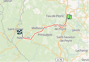
Tour Wandern von 26 km verfügbar auf Okzitanien, Lozère, Peyre en Aubrac. Diese Tour wird von DanielROLLET vorgeschlagen.
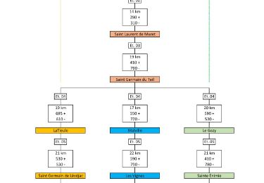
Beschreibung
2022 09 13 - GR65
Départ de l'hôtel Prunières
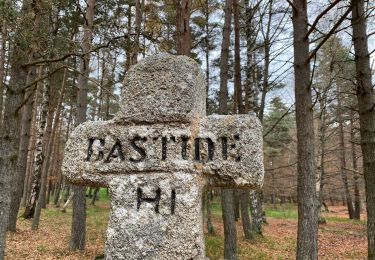
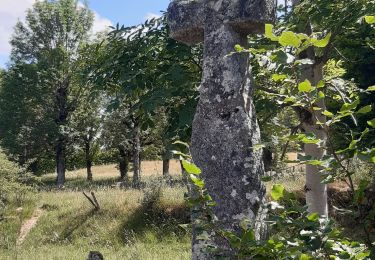
Étape sur le chemin de Compostelle
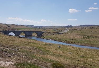
L’Aubrac s'est vraiment révélé après le hameau des "Quatre chemins"
Clôtures de chaque côté du chemin tout le long du parcours
Quelques gouttes en arrivant à l'hôtel de France
8h00 à 14h50 Etape relativement facile
Ort
Kommentare
Touren in der Umgebung
![Tour Wandern Peyre en Aubrac - Aumont Aubrac Nasbinal Avril 2018 - Photo](https://media.geolcdn.com/t/375/260/ext.jpg?maxdim=2&url=https%3A%2F%2Fservices.sitytrail.com%2FGeolivesWS%2FDownloadMedia.ashx%3FTrailID%3D954976%26Media%3Dfix__20180420140045.jpg)
![Wandern Wandern](https://static1.geolcdn.com/sitytour/trail-icons/101.png)
Wandern
![](/images/other/stat-length.png)
![](https://static1.geolcdn.com/siteimages/upload/files/16400158638029165_repeat_loop_refresh_sync_direction_icon.png)
![Tour Wandern Peyre en Aubrac - Compostelle Aumont-Nasbinals - Photo](https://media.geolcdn.com/t/375/260/ext.jpg?maxdim=2&url=https%3A%2F%2Fstatic1.geolcdn.com%2Fsiteimages%2Fupload%2Ffiles%2F1553511878bg_sport_marche.png)
![Wandern Wandern](https://static1.geolcdn.com/sitytour/trail-icons/101.png)
Wandern
![](/images/other/stat-length.png)
![](https://static1.geolcdn.com/siteimages/upload/files/16400158638029165_repeat_loop_refresh_sync_direction_icon.png)
![Tour Wandern Peyre en Aubrac - Lasbros - Photo](https://media.geolcdn.com/t/375/260/c0f2421e-e54c-492c-b4c7-7d17496731f8.jpg&format=jpg&maxdim=2)
![Wandern Wandern](https://static1.geolcdn.com/sitytour/trail-icons/101.png)
Wandern
![](/images/other/stat-length.png)
![](https://static1.geolcdn.com/siteimages/upload/files/16400158638029165_repeat_loop_refresh_sync_direction_icon.png)
![Tour Wandern Peyre en Aubrac - Étape 1 Saint Gilhem - Photo](https://media.geolcdn.com/t/375/260/2d822680-c426-4c5d-a29b-3495a4f31f4e.jpg&format=jpg&maxdim=2)
![Wandern Wandern](https://static1.geolcdn.com/sitytour/trail-icons/101.png)
Wandern
![](/images/other/stat-length.png)
![](https://static1.geolcdn.com/siteimages/upload/files/16400158638029165_repeat_loop_refresh_sync_direction_icon.png)
![Tour Wandern Peyre en Aubrac - Mon chemin de St Guilhem étape 1 - Photo](https://media.geolcdn.com/t/375/260/6d064fd1-514a-4cb7-a19e-2096a1e7542e.jpg&format=jpg&maxdim=2)
![Wandern Wandern](https://static1.geolcdn.com/sitytour/trail-icons/101.png)
Wandern
![](/images/other/stat-length.png)
![](https://static1.geolcdn.com/siteimages/upload/files/16400158638029165_repeat_loop_refresh_sync_direction_icon.png)
![Tour Wandern Peyre en Aubrac - les moulins? - Photo](https://media.geolcdn.com/t/375/260/2e35156a-9dac-4c6e-b0c4-947bc48e0da2.jpg&format=jpg&maxdim=2)
![Wandern Wandern](https://static1.geolcdn.com/sitytour/trail-icons/101.png)
Wandern
![](/images/other/stat-length.png)
![](https://static1.geolcdn.com/siteimages/upload/files/16400158638029165_repeat_loop_refresh_sync_direction_icon.png)
![Tour Wandern Peyre en Aubrac - le rocher du Cher - Photo](https://media.geolcdn.com/t/375/260/521b0f14-15fb-43d0-a0a1-e5e04c239576.jpg&format=jpg&maxdim=2)
![Wandern Wandern](https://static1.geolcdn.com/sitytour/trail-icons/101.png)
Wandern
![](/images/other/stat-length.png)
![](https://static1.geolcdn.com/siteimages/upload/files/16400158638029165_repeat_loop_refresh_sync_direction_icon.png)
![Tour Auto Peyre en Aubrac - javols - Photo](https://media.geolcdn.com/t/375/260/88751dea-9888-4bf8-b1cf-5a47c42c86ef.jpg&format=jpg&maxdim=2)
![Auto Auto](https://static1.geolcdn.com/sitytour/trail-icons/401.png)
Auto
![](/images/other/stat-length.png)
![](https://static1.geolcdn.com/siteimages/upload/files/16400158638029165_repeat_loop_refresh_sync_direction_icon.png)
![Tour Wandern Peyre en Aubrac - Chemin de St Guilhem - Variante N° 03 - Photo](https://media.geolcdn.com/t/375/260/5bf276c2-8829-4a43-964f-b59caa08d971.jpg&format=jpg&maxdim=2)
![Wandern Wandern](https://static1.geolcdn.com/sitytour/trail-icons/101.png)
Wandern
![](/images/other/stat-length.png)
![](https://static1.geolcdn.com/siteimages/upload/files/16400158638029165_repeat_loop_refresh_sync_direction_icon.png)