![](/images/other/stat-length.png)
![Tour Wandern Conamara Municipal District - Ballykine loop - Photo](https://media.geolcdn.com/t/1900/400/bdd6a203-ab49-47ac-ae0f-8bfe8133728f.jpg&format=pjpeg&maxdim=2)
Ballykine loop
M7184
Benutzer
![Länge](/images/other/stat-length.png)
Länge
7,2 km
![Maximale Höhe](https://static1.geolcdn.com/siteimages/upload/files/1508320355ic_sort_altitude_max_24dp.png)
Maximale Höhe
41 m
![Positive Höhendifferenz](https://static1.geolcdn.com/siteimages/upload/files/1508320355ic_sort_den_pos_24dp.png)
Positive Höhendifferenz
77 m
![Km-Effort](/images/other/stat-length.png)
Km-Effort
8,2 km
![Min. Höhe](https://static1.geolcdn.com/siteimages/upload/files/1508320355ic_sort_altitude_min_24dp.png)
Min. Höhe
18 m
![Negative Höhendifferenz](https://static1.geolcdn.com/siteimages/upload/files/1508320355ic_sort_den_neg_24dp.png)
Negative Höhendifferenz
78 m
![Boucle](https://static1.geolcdn.com/siteimages/upload/files/16400158638029165_repeat_loop_refresh_sync_direction_icon.png)
Boucle
Ja
Erstellungsdatum :
2022-09-09 13:17:27.598
Letzte Änderung :
2022-09-19 17:32:13.527
![Wandern](https://static1.geolcdn.com/sitytour/trail-icons/101.png)
1h52
Schwierigkeit : Sehr leicht
![Scannen Sie diesen QR-Code, um die Tour in der SityTrail-Anwendung zu öffnen](https://capi.geolives.com/qq0zvz2zws4bq2lad0pu/sitytour/trails/3385219/qr.png?size=200)
Kostenlosegpshiking-Anwendung
Über SityTrail
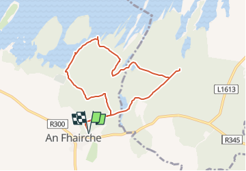
Tour Wandern von 7,2 km verfügbar auf Unbekannt, County Galway, Conamara Municipal District. Diese Tour wird von M7184 vorgeschlagen.
Beschreibung
An Fhairche
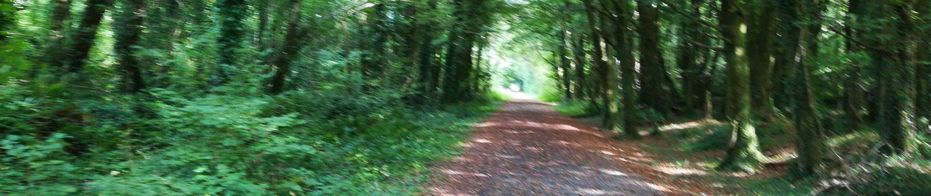
Parking aisé à côté de l'aire de jeu (Clonbur Wood car park), Aperçu de loin des ruines du Ballykine Castle et belles vue sur le lac "Lough Mask". Promenade facile, chemin large et bien tracé
Ort
Land:
Ireland
Region :
Unbekannt
Abteilung/Provinz :
County Galway
Kommune :
Conamara Municipal District
Standort:
Cloonbur ED
Gehen Sie:(Dec)
Gehen Sie:(UTM)
476071 ; 5933047 (29U) N.
Kommentare
Touren in der Umgebung
![Tour Zu Fuß Claremorris-Swinford Municipal District - Cong Nature Trail - Photo](https://media.geolcdn.com/t/375/260/ce64bd19-1601-4537-a139-a51573b6812b.jpeg&format=jpg&maxdim=2)
![Zu Fuß Zu Fuß](https://static1.geolcdn.com/sitytour/trail-icons/100.png)
Cong Nature Trail
Zu Fuß
Einfach
Claremorris-Swinford Municipal District,
Unbekannt,
County Mayo,
Ireland
![](/images/other/stat-length.png)
3,9 km | 4,4 km-effort
1h 0min
![](https://static1.geolcdn.com/siteimages/upload/files/16400158638029165_repeat_loop_refresh_sync_direction_icon.png)
Ja
![Tour Wandern Conamara Municipal District - cong - Photo](https://media.geolcdn.com/t/375/260/ext.jpg?maxdim=2&url=https%3A%2F%2Fstatic1.geolcdn.com%2Fsiteimages%2Fupload%2Ffiles%2F1553511878bg_sport_marche.png)
![Wandern Wandern](https://static1.geolcdn.com/sitytour/trail-icons/101.png)
cong
Wandern
Sehr leicht
Conamara Municipal District,
Unbekannt,
County Galway,
Ireland
![](/images/other/stat-length.png)
3 km | 3,3 km-effort
46min
![](https://static1.geolcdn.com/siteimages/upload/files/16400158638029165_repeat_loop_refresh_sync_direction_icon.png)
Nein