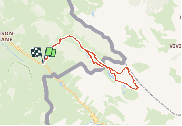
![](/images/other/stat-length.png)
![Tour Wandern Val-d'Oronaye - Monté Scaletta - Photo](https://media.geolcdn.com/t/1900/400/ext.pjpeg?maxdim=2&url=https%3A%2F%2Fstatic1.geolcdn.com%2Fsiteimages%2Fupload%2Ffiles%2F1553511878bg_sport_marche.png)
Monté Scaletta
GAPIAN43
Benutzer
![Länge](/images/other/stat-length.png)
![Maximale Höhe](https://static1.geolcdn.com/siteimages/upload/files/1508320355ic_sort_altitude_max_24dp.png)
![Positive Höhendifferenz](https://static1.geolcdn.com/siteimages/upload/files/1508320355ic_sort_den_pos_24dp.png)
![Km-Effort](/images/other/stat-length.png)
![Min. Höhe](https://static1.geolcdn.com/siteimages/upload/files/1508320355ic_sort_altitude_min_24dp.png)
![Negative Höhendifferenz](https://static1.geolcdn.com/siteimages/upload/files/1508320355ic_sort_den_neg_24dp.png)
![Boucle](https://static1.geolcdn.com/siteimages/upload/files/16400158638029165_repeat_loop_refresh_sync_direction_icon.png)
![Wandern](https://static1.geolcdn.com/sitytour/trail-icons/101.png)
6h15
Schwierigkeit : Medium
![Scannen Sie diesen QR-Code, um die Tour in der SityTrail-Anwendung zu öffnen](https://capi.geolives.com/qq0zvz2zws4bq2lad0pu/sitytour/trails/337845/qr.png?size=200)
Kostenlosegpshiking-Anwendung
Über SityTrail
Tour Wandern von 15,9 km verfügbar auf Provence-Alpes-Côte d'Azur, Alpes-de-Haute-Provence, Val-d'Oronaye. Diese Tour wird von GAPIAN43 vorgeschlagen.
Beschreibung
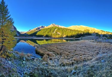
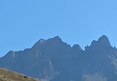
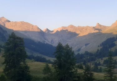
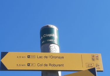
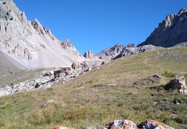
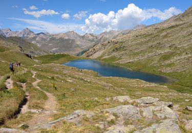
Depuis le col de Larche, suivre le sentier qui monte en diagonale vers la source des Pains Bouillis. Remonter le long du torrent de l'Orrenaye. À la cote 2230 prenait à droite dans le grand vallon, contourner le lac de l'Orrénaye par la gauche. Suivre un bon sentier jusque sur la crête qui domine le lac de Roburent. (Cote 2502). Descendre vers le lac et prendre le sentier très raide qui part sur la gauche. ( GR Tour du Chambeyron). Au col della Scaletta prendre sur la droite un sentier qui grimpe dans les éboulis. À partir de là, la rando s'apparente à une rando Alpine. On ne peut pas se tromper il n'y a qu'un seul sentier. Prévoir une lampe frontale pour traverser un tunnel. ( Vestiges de fortifications Italiennes). A la sortie du tunnel les choses se corsent encore un peu, mais rien de bien méchant. Suivre la crête jusqu'au sommet. Possibilité de visiter quelques vestiges militaires. Suivre le sentier bien marqué qui descend versant Italien. Succession de montées et descentes en fait. Passages sublimes. Pas de risques, suivre les câbles ou les chaines en place. Magnifique point de vue sur les deux lacs inférieurs de Roburent. Au sortir des rochers continuaient sur le sentier le plus loin possible avant de descendre dans les éboulis pour rejoindre un autre sentier un peu plus bas qui remonte vers le lac supérieur de Roburent. À la cote 2502 vous pouvez soit revenir par le même sentier soit contourner le lac de l'Orrénaye par la gauche.
Ort
Kommentare
Touren in der Umgebung
![Tour Wandern Jausiers - Cîme de Voga Via Jausier (lac de Sagne) - Photo](https://media.geolcdn.com/t/375/260/765bd632-4e4c-4e4b-9c51-061ee1a2012f.jpg&format=jpg&maxdim=2)
![Wandern Wandern](https://static1.geolcdn.com/sitytour/trail-icons/101.png)
Wandern
![](/images/other/stat-length.png)
![](https://static1.geolcdn.com/siteimages/upload/files/16400158638029165_repeat_loop_refresh_sync_direction_icon.png)
![Tour Wandern Val-d'Oronaye - LARCHE lac de la Orenaille .Tour du lac de Roburent o - Photo](https://media.geolcdn.com/t/375/260/ext.jpg?maxdim=2&url=https%3A%2F%2Fstatic1.geolcdn.com%2Fsiteimages%2Fupload%2Ffiles%2F1553511878bg_sport_marche.png)
![Wandern Wandern](https://static1.geolcdn.com/sitytour/trail-icons/101.png)
Wandern
![](/images/other/stat-length.png)
![](https://static1.geolcdn.com/siteimages/upload/files/16400158638029165_repeat_loop_refresh_sync_direction_icon.png)
![Tour Wandern Val-d'Oronaye - LARCHE , lac de l Oronaye et lac de Roburent o - Photo](https://media.geolcdn.com/t/375/260/316d066b-2aef-4992-b2fc-125a388690b9.jpg&format=jpg&maxdim=2)
![Wandern Wandern](https://static1.geolcdn.com/sitytour/trail-icons/101.png)
Wandern
![](/images/other/stat-length.png)
![](https://static1.geolcdn.com/siteimages/upload/files/16400158638029165_repeat_loop_refresh_sync_direction_icon.png)
![Tour Wandern Val-d'Oronaye - LARCHE , lac du Lauzanier . lac de derrière la Croix o - Photo](https://media.geolcdn.com/t/375/260/3bbe0ab1-c5da-40d1-ad40-82b025b25f82.jpg&format=jpg&maxdim=2)
![Wandern Wandern](https://static1.geolcdn.com/sitytour/trail-icons/101.png)
Wandern
![](/images/other/stat-length.png)
![](https://static1.geolcdn.com/siteimages/upload/files/16400158638029165_repeat_loop_refresh_sync_direction_icon.png)
![Tour Wandern Val-d'Oronaye - LARCHE lac de l Oronaye col de Robutent p - Photo](https://media.geolcdn.com/t/375/260/f4dfe0bc-74a3-4d66-9579-99bd1f8a7d2a.jpg&format=jpg&maxdim=2)
![Wandern Wandern](https://static1.geolcdn.com/sitytour/trail-icons/101.png)
Wandern
![](/images/other/stat-length.png)
![](https://static1.geolcdn.com/siteimages/upload/files/16400158638029165_repeat_loop_refresh_sync_direction_icon.png)
![Tour Wandern Val-d'Oronaye - Rando Tête de SAUTRON-Tête de VIRAYSSE - Photo](https://media.geolcdn.com/t/375/260/65cefd2c-b44d-4824-8624-ae2c9dbc6934.jpg&format=jpg&maxdim=2)
![Wandern Wandern](https://static1.geolcdn.com/sitytour/trail-icons/101.png)
Wandern
![](/images/other/stat-length.png)
![](https://static1.geolcdn.com/siteimages/upload/files/16400158638029165_repeat_loop_refresh_sync_direction_icon.png)
![Tour Wandern Val-d'Oronaye - oronaye roburent - Photo](https://media.geolcdn.com/t/375/260/ext.jpg?maxdim=2&url=https%3A%2F%2Fstatic1.geolcdn.com%2Fsiteimages%2Fupload%2Ffiles%2F1553511878bg_sport_marche.png)
![Wandern Wandern](https://static1.geolcdn.com/sitytour/trail-icons/101.png)
Wandern
![](/images/other/stat-length.png)
![](https://static1.geolcdn.com/siteimages/upload/files/16400158638029165_repeat_loop_refresh_sync_direction_icon.png)
![Tour Wandern Val-d'Oronaye - Batterie de Viraysse - Photo](https://media.geolcdn.com/t/375/260/ext.jpg?maxdim=2&url=https%3A%2F%2Fstatic1.geolcdn.com%2Fsiteimages%2Fupload%2Ffiles%2F1553511878bg_sport_marche.png)
![Wandern Wandern](https://static1.geolcdn.com/sitytour/trail-icons/101.png)
Wandern
![](/images/other/stat-length.png)
![](https://static1.geolcdn.com/siteimages/upload/files/16400158638029165_repeat_loop_refresh_sync_direction_icon.png)
![Tour Wandern Val-d'Oronaye - lac des hommes et lac de derrière la croix - Photo](https://media.geolcdn.com/t/375/260/218c6528-828b-4932-9c02-bcf14946edaa.jpg&format=jpg&maxdim=2)
![Wandern Wandern](https://static1.geolcdn.com/sitytour/trail-icons/101.png)
Wandern
![](/images/other/stat-length.png)
![](https://static1.geolcdn.com/siteimages/upload/files/16400158638029165_repeat_loop_refresh_sync_direction_icon.png)