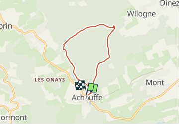
![](/images/other/stat-length.png)
![Tour Wandern Hohenfels - Achouffe: La Vallée des Fées - Photo](https://media.geolcdn.com/t/1900/400/1bf267f6-5985-4265-be2c-a5baafaae91d.jpeg&format=pjpeg&maxdim=2)
Achouffe: La Vallée des Fées
Benjamin27
Benutzer GUIDE
![Länge](/images/other/stat-length.png)
![Maximale Höhe](https://static1.geolcdn.com/siteimages/upload/files/1508320355ic_sort_altitude_max_24dp.png)
![Positive Höhendifferenz](https://static1.geolcdn.com/siteimages/upload/files/1508320355ic_sort_den_pos_24dp.png)
![Km-Effort](/images/other/stat-length.png)
![Min. Höhe](https://static1.geolcdn.com/siteimages/upload/files/1508320355ic_sort_altitude_min_24dp.png)
![Negative Höhendifferenz](https://static1.geolcdn.com/siteimages/upload/files/1508320355ic_sort_den_neg_24dp.png)
![Boucle](https://static1.geolcdn.com/siteimages/upload/files/16400158638029165_repeat_loop_refresh_sync_direction_icon.png)
![Wandern](https://static1.geolcdn.com/sitytour/trail-icons/101.png)
1h34
Schwierigkeit : Medium
![Scannen Sie diesen QR-Code, um die Tour in der SityTrail-Anwendung zu öffnen](https://capi.geolives.com/qq0zvz2zws4bq2lad0pu/sitytour/trails/3369121/qr.png?size=200)
Kostenlosegpshiking-Anwendung
Über SityTrail
Tour Wandern von 5,3 km verfügbar auf Wallonien, Luxemburg, Hohenfels. Diese Tour wird von Benjamin27 vorgeschlagen.
Beschreibung
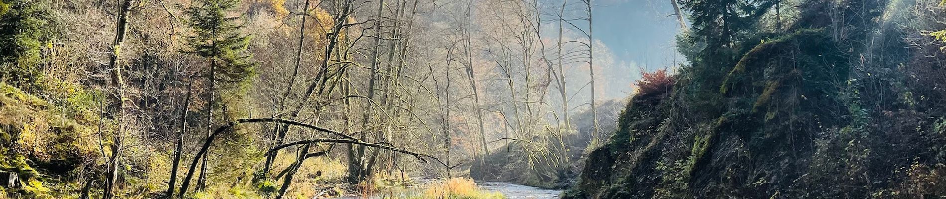
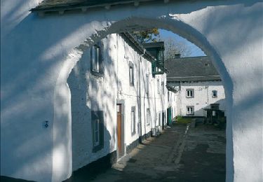
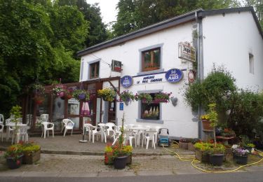
Achouffe, situé au fond de la vallée des fées à la rencontre du ruisseau de Martin-Moulin et de celui du Chevral, est un des plus petits et des plus charmants villages de l'entité. A la confluence des deux cours d’eau, la Pisciculture Domaniale a été fondée près du pont. Village touristique par excellence, Achouffe est entre autres connu pour sa brasserie. Fondée par deux beaux-frères, l'un wallon et l'autre flamand, dans une ancienne ferme, la Chouffe est brassée exclusivement avec l'eau de la source de Cedrogne qui lui assure sa saveur. Connaissez-vous la légende des Nutons ? Ces personnages nains, typiquement ardennais, vivaient dans une grotte (tel le Trou des Nutons, Route de La Roche à Houffalize) et possédaient un tunnel allant jusqu'à la chapelle Notre-Dame de Fôret, entre Taverneux et Sommerain. Durant la nuit, ils réparaient les chaussures des Houffalois. D'où la popularité d'Houffalize en tant que cité des Nutons. En 1807, deux réfractaires de la localité se réfugièrent dans le trou. Ils étaient cordonniers. La nuit, les habitants du pays déposaient leurs souliers déchirés ainsi que des provisions à l'entrée de la grotte. Le lendemain, ils les trouvaient réparés.
Ort
Kommentare
Touren in der Umgebung
![Tour Wandern Hohenfels - RB-LUX-06 - Près des sources de l’Ourthe orientale - Photo](https://media.geolcdn.com/t/375/260/ext.jpg?maxdim=2&url=https%3A%2F%2Fservices.sitytrail.com%2FGeolivesWS%2FDownloadMedia.ashx%3FTrailID%3D179619%26Media%3D8b2c6c16-f84f-40f5-b4fd-5755f63e797b.jpg)
![Wandern Wandern](https://static1.geolcdn.com/sitytour/trail-icons/101.png)
Wandern
![](/images/other/stat-length.png)
![](https://static1.geolcdn.com/siteimages/upload/files/16400158638029165_repeat_loop_refresh_sync_direction_icon.png)
![Tour Wandern Hohenfels - Houffalize 24 Km - Photo](https://media.geolcdn.com/t/375/260/f2a4fe24-3182-45a1-8c4e-78921a8d2df8.jpg&format=jpg&maxdim=2)
![Wandern Wandern](https://static1.geolcdn.com/sitytour/trail-icons/101.png)
Wandern
![](/images/other/stat-length.png)
![](https://static1.geolcdn.com/siteimages/upload/files/16400158638029165_repeat_loop_refresh_sync_direction_icon.png)
![Tour Wandern Hohenfels - Nadrin et le Rocher du Hérou - Photo](https://media.geolcdn.com/t/375/260/ext.jpg?maxdim=2&url=https%3A%2F%2Fservices.sitytrail.com%2FGeolivesWS%2FDownloadMedia.ashx%3FTrailID%3D1009974%26Media%3D6524bd08-d031-4749-9180-8d830da29ec9.jpg)
![Wandern Wandern](https://static1.geolcdn.com/sitytour/trail-icons/101.png)
Wandern
![](/images/other/stat-length.png)
![](https://static1.geolcdn.com/siteimages/upload/files/16400158638029165_repeat_loop_refresh_sync_direction_icon.png)
![Wandern Wandern](https://static1.geolcdn.com/sitytour/trail-icons/101.png)
Wandern
![](/images/other/stat-length.png)
![](https://static1.geolcdn.com/siteimages/upload/files/16400158638029165_repeat_loop_refresh_sync_direction_icon.png)
![Wandern Wandern](https://static1.geolcdn.com/sitytour/trail-icons/101.png)
Wandern
![](/images/other/stat-length.png)
![](https://static1.geolcdn.com/siteimages/upload/files/16400158638029165_repeat_loop_refresh_sync_direction_icon.png)
![Tour Wandern Hohenfels - Brug van Suhet - Photo](https://media.geolcdn.com/t/375/260/ext.jpg?maxdim=2&url=https%3A%2F%2Fservices.sitytrail.com%2FGeolivesWS%2FDownloadMedia.ashx%3FTrailID%3D485759%26Media%3Dc0a9257a-f8ac-4145-a29f-af09ef232c22.jpg)
![Wandern Wandern](https://static1.geolcdn.com/sitytour/trail-icons/101.png)
Wandern
![](/images/other/stat-length.png)
![](https://static1.geolcdn.com/siteimages/upload/files/16400158638029165_repeat_loop_refresh_sync_direction_icon.png)
![Tour Wandern Hohenfels - Sint-Rochuskapel - Photo](https://media.geolcdn.com/t/375/260/ext.jpg?maxdim=2&url=https%3A%2F%2Fservices.sitytrail.com%2FGeolivesWS%2FDownloadMedia.ashx%3FTrailID%3D485651%26Media%3Deb728c68-2a3c-4799-8033-bf1dbca1b439.jpg)
![Wandern Wandern](https://static1.geolcdn.com/sitytour/trail-icons/101.png)
Wandern
![](/images/other/stat-length.png)
![](https://static1.geolcdn.com/siteimages/upload/files/16400158638029165_repeat_loop_refresh_sync_direction_icon.png)
![Tour Wandern Hohenfels - Alhoumont - Photo](https://media.geolcdn.com/t/375/260/ext.jpg?maxdim=2&url=https%3A%2F%2Fservices.sitytrail.com%2FGeolivesWS%2FDownloadMedia.ashx%3FTrailID%3D485603%26Media%3Dab9e328f-2fba-4db4-9e4f-b4c6fc69c80e.jpg)
![Wandern Wandern](https://static1.geolcdn.com/sitytour/trail-icons/101.png)
Wandern
![](/images/other/stat-length.png)
![](https://static1.geolcdn.com/siteimages/upload/files/16400158638029165_repeat_loop_refresh_sync_direction_icon.png)
![Tour Wandern Hohenfels - Stadswandeling Houffalize - Photo](https://media.geolcdn.com/t/375/260/ext.jpg?maxdim=2&url=https%3A%2F%2Fservices.sitytrail.com%2FGeolivesWS%2FDownloadMedia.ashx%3FTrailID%3D481711%26Media%3Dd8f3bf4c-0099-44fd-93ae-681a17a948e5.jpg)
![Wandern Wandern](https://static1.geolcdn.com/sitytour/trail-icons/101.png)
Wandern
![](/images/other/stat-length.png)
![](https://static1.geolcdn.com/siteimages/upload/files/16400158638029165_repeat_loop_refresh_sync_direction_icon.png)