![](/images/other/stat-length.png)
![Tour Wandern Bost - AVF reconnaissance Bost - Photo](https://media.geolcdn.com/t/1900/400/ext.pjpeg?maxdim=2&url=https%3A%2F%2Fstatic1.geolcdn.com%2Fsiteimages%2Fupload%2Ffiles%2F1553511878bg_sport_marche.png)
AVF reconnaissance Bost
MBMaes
Benutzer
![Länge](/images/other/stat-length.png)
Länge
9,9 km
![Maximale Höhe](https://static1.geolcdn.com/siteimages/upload/files/1508320355ic_sort_altitude_max_24dp.png)
Maximale Höhe
331 m
![Positive Höhendifferenz](https://static1.geolcdn.com/siteimages/upload/files/1508320355ic_sort_den_pos_24dp.png)
Positive Höhendifferenz
138 m
![Km-Effort](/images/other/stat-length.png)
Km-Effort
11,7 km
![Min. Höhe](https://static1.geolcdn.com/siteimages/upload/files/1508320355ic_sort_altitude_min_24dp.png)
Min. Höhe
261 m
![Negative Höhendifferenz](https://static1.geolcdn.com/siteimages/upload/files/1508320355ic_sort_den_neg_24dp.png)
Negative Höhendifferenz
137 m
![Boucle](https://static1.geolcdn.com/siteimages/upload/files/16400158638029165_repeat_loop_refresh_sync_direction_icon.png)
Boucle
Ja
Erstellungsdatum :
2022-08-25 06:56:35.827
Letzte Änderung :
2022-08-28 17:39:18.694
![Wandern](https://static1.geolcdn.com/sitytour/trail-icons/101.png)
2h52
Schwierigkeit : Schwierig
![Scannen Sie diesen QR-Code, um die Tour in der SityTrail-Anwendung zu öffnen](https://capi.geolives.com/qq0zvz2zws4bq2lad0pu/sitytour/trails/3367352/qr.png?size=200)
Kostenlosegpshiking-Anwendung
Über SityTrail
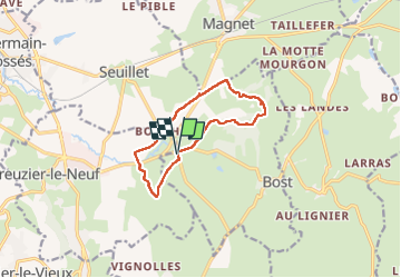
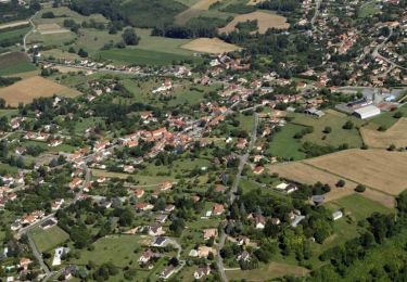
Tour Wandern von 9,9 km verfügbar auf Auvergne-Rhone-Alpen, Allier, Bost. Diese Tour wird von MBMaes vorgeschlagen.
Beschreibung
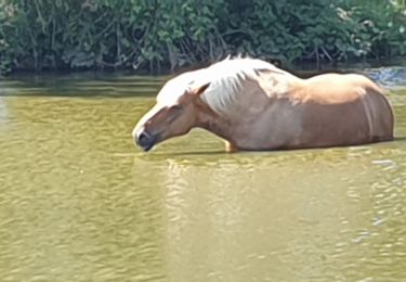
Petite rando menée par Patrick Vichy Rando en Août 2022.
Pas grand intérêt dans le deuxième partie, mais tracé à conserver pour une rando facile AVF
Ort
Land:
France
Region :
Auvergne-Rhone-Alpen
Abteilung/Provinz :
Allier
Kommune :
Bost
Standort:
Unknown
Gehen Sie:(Dec)
Gehen Sie:(UTM)
537698 ; 5114712 (31T) N.
Kommentare
Touren in der Umgebung
![Tour Wandern Creuzier-le-Vieux - Circuit bleu de Creuzier-Le-Vieux - Photo](https://media.geolcdn.com/t/375/260/ext.jpg?maxdim=2&url=https%3A%2F%2Fservices.sitytrail.com%2FGeolivesWS%2FDownloadMedia.ashx%3FTrailID%3D112767%26Media%3D12154_3.jpg)
![Wandern Wandern](https://static1.geolcdn.com/sitytour/trail-icons/101.png)
Circuit bleu de Creuzier-Le-Vieux
Wandern
Einfach
(1)
Creuzier-le-Vieux,
Auvergne-Rhone-Alpen,
Allier,
France
![](/images/other/stat-length.png)
4,5 km | 5,9 km-effort
1h 10min
![](https://static1.geolcdn.com/siteimages/upload/files/16400158638029165_repeat_loop_refresh_sync_direction_icon.png)
Ja
![Tour Wandern Creuzier-le-Vieux - Circuit Jaune de Creuzier Le Vieux - Photo](https://media.geolcdn.com/t/375/260/ext.jpg?maxdim=2&url=https%3A%2F%2Fservices.sitytrail.com%2FGeolivesWS%2FDownloadMedia.ashx%3FTrailID%3D112766%26Media%3D12149_4.jpg)
![Wandern Wandern](https://static1.geolcdn.com/sitytour/trail-icons/101.png)
Circuit Jaune de Creuzier Le Vieux
Wandern
Einfach
Creuzier-le-Vieux,
Auvergne-Rhone-Alpen,
Allier,
France
![](/images/other/stat-length.png)
7,2 km | 9,5 km-effort
1h 49min
![](https://static1.geolcdn.com/siteimages/upload/files/16400158638029165_repeat_loop_refresh_sync_direction_icon.png)
Ja
![Tour Wandern Bost - Les Gouttes Noires - Bost - Photo](https://media.geolcdn.com/t/375/260/ext.jpg?maxdim=2&url=https%3A%2F%2Fservices.sitytrail.com%2FGeolivesWS%2FDownloadMedia.ashx%3FTrailID%3D106560%26Media%3D11131_5.jpg)
![Wandern Wandern](https://static1.geolcdn.com/sitytour/trail-icons/101.png)
Les Gouttes Noires - Bost
Wandern
Medium
Bost,
Auvergne-Rhone-Alpen,
Allier,
France
![](/images/other/stat-length.png)
14,4 km | 18,4 km-effort
3h 34min
![](https://static1.geolcdn.com/siteimages/upload/files/16400158638029165_repeat_loop_refresh_sync_direction_icon.png)
Ja
![Tour Wandern Bost - bost bof - Photo](https://media.geolcdn.com/t/375/260/2ea7e5ba-20ed-4199-8b96-a4e8082f4455.jpg&format=jpg&maxdim=2)
![Wandern Wandern](https://static1.geolcdn.com/sitytour/trail-icons/101.png)
bost bof
Wandern
Medium
Bost,
Auvergne-Rhone-Alpen,
Allier,
France
![](/images/other/stat-length.png)
13,5 km | 17,4 km-effort
3h 43min
![](https://static1.geolcdn.com/siteimages/upload/files/16400158638029165_repeat_loop_refresh_sync_direction_icon.png)
Ja
![Tour Wandern Bost - Randonnée, Les, goutte Noire, Vichy, 2023 - Photo](https://media.geolcdn.com/t/375/260/ext.jpg?maxdim=2&url=https%3A%2F%2Fstatic1.geolcdn.com%2Fsiteimages%2Fupload%2Ffiles%2F1553511878bg_sport_marche.png)
![Wandern Wandern](https://static1.geolcdn.com/sitytour/trail-icons/101.png)
Randonnée, Les, goutte Noire, Vichy, 2023
Wandern
Medium
Bost,
Auvergne-Rhone-Alpen,
Allier,
France
![](/images/other/stat-length.png)
7,1 km | 9,7 km-effort
1h 45min
![](https://static1.geolcdn.com/siteimages/upload/files/16400158638029165_repeat_loop_refresh_sync_direction_icon.png)
Ja
![Tour Wandern Creuzier-le-Vieux - Creuzier le vieux octobre 2021 - Photo](https://media.geolcdn.com/t/375/260/ext.jpg?maxdim=2&url=https%3A%2F%2Fstatic1.geolcdn.com%2Fsiteimages%2Fupload%2Ffiles%2F1553511878bg_sport_marche.png)
![Wandern Wandern](https://static1.geolcdn.com/sitytour/trail-icons/101.png)
Creuzier le vieux octobre 2021
Wandern
Medium
Creuzier-le-Vieux,
Auvergne-Rhone-Alpen,
Allier,
France
![](/images/other/stat-length.png)
12,5 km | 16,2 km-effort
2h 55min
![](https://static1.geolcdn.com/siteimages/upload/files/16400158638029165_repeat_loop_refresh_sync_direction_icon.png)
Ja
![Tour Wandern Creuzier-le-Vieux - Damien - Photo](https://media.geolcdn.com/t/375/260/ext.jpg?maxdim=2&url=https%3A%2F%2Fstatic1.geolcdn.com%2Fsiteimages%2Fupload%2Ffiles%2F1553511878bg_sport_marche.png)
![Wandern Wandern](https://static1.geolcdn.com/sitytour/trail-icons/101.png)
Damien
Wandern
Einfach
Creuzier-le-Vieux,
Auvergne-Rhone-Alpen,
Allier,
France
![](/images/other/stat-length.png)
4,7 km | 5,8 km-effort
1h 10min
![](https://static1.geolcdn.com/siteimages/upload/files/16400158638029165_repeat_loop_refresh_sync_direction_icon.png)
Nein
![Tour Wandern Saint-Étienne-de-Vicq - La Bruyère - Saint Christophe - Photo](https://media.geolcdn.com/t/375/260/ext.jpg?maxdim=2&url=https%3A%2F%2Fstatic1.geolcdn.com%2Fsiteimages%2Fupload%2Ffiles%2F1553511878bg_sport_marche.png)
![Wandern Wandern](https://static1.geolcdn.com/sitytour/trail-icons/101.png)
La Bruyère - Saint Christophe
Wandern
Sehr schwierig
Saint-Étienne-de-Vicq,
Auvergne-Rhone-Alpen,
Allier,
France
![](/images/other/stat-length.png)
17,4 km | 22 km-effort
4h 46min
![](https://static1.geolcdn.com/siteimages/upload/files/16400158638029165_repeat_loop_refresh_sync_direction_icon.png)
Ja
![Tour Andere Aktivitäten Saint-Étienne-de-Vicq - st etienne de vicq - Photo](https://media.geolcdn.com/t/375/260/ext.jpg?maxdim=2&url=https%3A%2F%2Fstatic1.geolcdn.com%2Fsiteimages%2Fupload%2Ffiles%2F1545311037marcheuse_200dpi.jpg)
![Andere Aktivitäten Andere Aktivitäten](https://static1.geolcdn.com/sitytour/trail-icons/900.png)
st etienne de vicq
Andere Aktivitäten
Sehr leicht
Saint-Étienne-de-Vicq,
Auvergne-Rhone-Alpen,
Allier,
France
![](/images/other/stat-length.png)
12,6 km | 16,7 km-effort
3h 14min
![](https://static1.geolcdn.com/siteimages/upload/files/16400158638029165_repeat_loop_refresh_sync_direction_icon.png)
Ja