![](/images/other/stat-length.png)
![Tour Wandern Bonneval-sur-Arc - col de la Disgrâce - Photo](https://media.geolcdn.com/t/1900/400/af5e664a-ccb0-4253-9e87-a4c863e84836.jpg&format=pjpeg&maxdim=2)
col de la Disgrâce
amiral13
Benutzer GUIDE
![Länge](/images/other/stat-length.png)
![Maximale Höhe](https://static1.geolcdn.com/siteimages/upload/files/1508320355ic_sort_altitude_max_24dp.png)
![Positive Höhendifferenz](https://static1.geolcdn.com/siteimages/upload/files/1508320355ic_sort_den_pos_24dp.png)
![Km-Effort](/images/other/stat-length.png)
![Min. Höhe](https://static1.geolcdn.com/siteimages/upload/files/1508320355ic_sort_altitude_min_24dp.png)
![Negative Höhendifferenz](https://static1.geolcdn.com/siteimages/upload/files/1508320355ic_sort_den_neg_24dp.png)
![Boucle](https://static1.geolcdn.com/siteimages/upload/files/16400158638029165_repeat_loop_refresh_sync_direction_icon.png)
![Wandern](https://static1.geolcdn.com/sitytour/trail-icons/101.png)
8h36
Schwierigkeit : Sehr schwierig
![Scannen Sie diesen QR-Code, um die Tour in der SityTrail-Anwendung zu öffnen](https://capi.geolives.com/qq0zvz2zws4bq2lad0pu/sitytour/trails/3365839/qr.png?size=200)
Kostenlosegpshiking-Anwendung
Über SityTrail
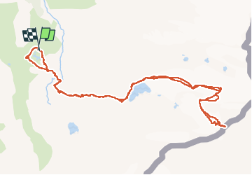
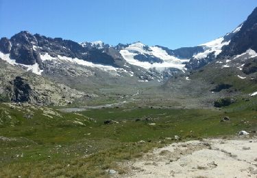
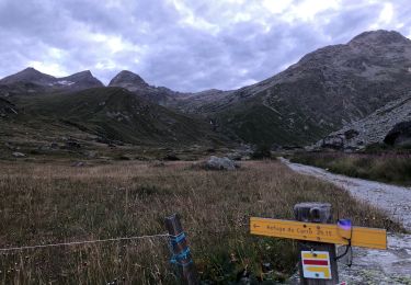
Tour Wandern von 13,7 km verfügbar auf Auvergne-Rhone-Alpen, Savoyen, Bonneval-sur-Arc. Diese Tour wird von amiral13 vorgeschlagen.
Beschreibung
course réalisée le 23 aout 2022
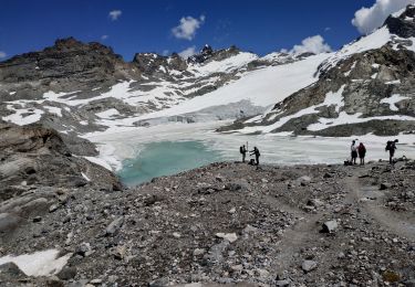
attention il s'agit d'alpinisme facile; il est donc nécessaire de posséder les compétences et le matériel nécessaire. Vous pouvez bien sur solliciter les services d'un guide.
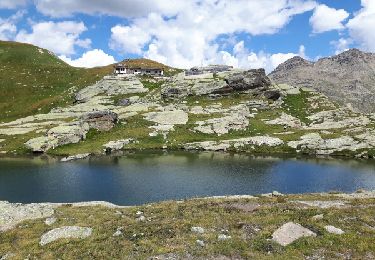
Au départ du refuge préférer repartir vers l'ouest pour récupérer une sente beaucoup plus roulante, vous y gagnerez du temps.
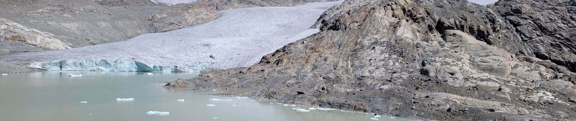
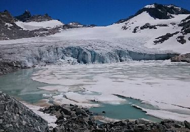
Su le glacier, on ne peut plus monter en trace directe vers le col car le Glacier n'existe plus sur un tronçon et vous vous trouveriez face à une barre rocheuse. Il vous faudra remonter le glacier du grand méan en rejoignant sa rive droite vers la côte 3150 (attention zone crevassée) à cet endroit une bande glacière rejoint encore le glacier qui monte au col; cela vous coutera 70 à 80 mètres de dénivelée à descendre et à remonter au retour. une autre cordée a choisi de prendre pieds sur la barre rocheuse vers la côte 3100, mais avoir discuté avec eux ça n'était pas forcément un bon choix.
Sous le col, une autre zone crevassée nous a encore barré le passage et nous avons du louvoyer, pour l'atteindre.
Au retour, nous avons tenté de remonter d'une trentaine de mètres supplémentaires pour éviter la partie raide et très crevassée, mais cela n'a rien apporté, retour au parcours de montée.
Ort
Kommentare
Touren in der Umgebung
![Tour Wandern Bonneval-sur-Arc - Lac du Grand Mean - Photo](https://media.geolcdn.com/t/375/260/ext.jpg?maxdim=2&url=https%3A%2F%2Fservices.sitytrail.com%2FGeolivesWS%2FDownloadMedia.ashx%3FTrailID%3D806759%26Media%3Dfix__20170715120723.jpg)
![Wandern Wandern](https://static1.geolcdn.com/sitytour/trail-icons/101.png)
Wandern
![](/images/other/stat-length.png)
![](https://static1.geolcdn.com/siteimages/upload/files/16400158638029165_repeat_loop_refresh_sync_direction_icon.png)
![Tour Andere Aktivitäten Bonneval-sur-Arc - splitboard à bonneval sur arc - Photo](https://media.geolcdn.com/t/375/260/ext.jpg?maxdim=2&url=https%3A%2F%2Fservices.sitytrail.com%2FGeolivesWS%2FDownloadMedia.ashx%3FTrailID%3D261086%26Media%3Dfix__20140328120952.jpg)
![Andere Aktivitäten Andere Aktivitäten](https://static1.geolcdn.com/sitytour/trail-icons/900.png)
Andere Aktivitäten
![](/images/other/stat-length.png)
![](https://static1.geolcdn.com/siteimages/upload/files/16400158638029165_repeat_loop_refresh_sync_direction_icon.png)
![Tour Wandern Bonneval-sur-Arc - Refuge des Evettes - Photo](https://media.geolcdn.com/t/375/260/ext.jpg?maxdim=2&url=https%3A%2F%2Fservices.sitytrail.com%2FGeolivesWS%2FDownloadMedia.ashx%3FTrailID%3D213475%26Media%3Dfix__20130815135904.jpg)
![Wandern Wandern](https://static1.geolcdn.com/sitytour/trail-icons/101.png)
Wandern
![](/images/other/stat-length.png)
![](https://static1.geolcdn.com/siteimages/upload/files/16400158638029165_repeat_loop_refresh_sync_direction_icon.png)
![Tour Wandern Bonneval-sur-Arc - Bonneval-sur-Arc / Bessans [neige] - J4 - Photo](https://media.geolcdn.com/t/375/260/28d35c22-b143-4338-8bb6-93842cf637ce.jpg&format=jpg&maxdim=2)
![Wandern Wandern](https://static1.geolcdn.com/sitytour/trail-icons/101.png)
Wandern
![](/images/other/stat-length.png)
![](https://static1.geolcdn.com/siteimages/upload/files/16400158638029165_repeat_loop_refresh_sync_direction_icon.png)
![Tour Wandern Bonneval-sur-Arc - refuge des Evettes - Photo](https://media.geolcdn.com/t/375/260/ext.jpg?maxdim=2&url=https%3A%2F%2Fservices.sitytrail.com%2FGeolivesWS%2FDownloadMedia.ashx%3FTrailID%3D614529%26Media%3Dfix__20160814130012.jpg)
![Wandern Wandern](https://static1.geolcdn.com/sitytour/trail-icons/101.png)
Wandern
![](/images/other/stat-length.png)
![](https://static1.geolcdn.com/siteimages/upload/files/16400158638029165_repeat_loop_refresh_sync_direction_icon.png)
![Tour Wandern Bonneval-sur-Arc - ballade Ecot - Photo](https://media.geolcdn.com/t/375/260/f8ea2366-0f30-48be-b4aa-6a939367d33d.jpg&format=jpg&maxdim=2)
![Wandern Wandern](https://static1.geolcdn.com/sitytour/trail-icons/101.png)
Wandern
![](/images/other/stat-length.png)
![](https://static1.geolcdn.com/siteimages/upload/files/16400158638029165_repeat_loop_refresh_sync_direction_icon.png)
![Tour Wandern Bonneval-sur-Arc - Evettes 73 - Photo](https://media.geolcdn.com/t/375/260/48b00260-0845-463c-94f0-ffded24a3c98.jpg&format=jpg&maxdim=2)
![Wandern Wandern](https://static1.geolcdn.com/sitytour/trail-icons/101.png)
Wandern
![](/images/other/stat-length.png)
![](https://static1.geolcdn.com/siteimages/upload/files/16400158638029165_repeat_loop_refresh_sync_direction_icon.png)
![Tour Wandern Bonneval-sur-Arc - Levanna Occidentale en partant de l'Ecot - Photo](https://media.geolcdn.com/t/375/260/9404e77c-6947-4db3-a8b0-cf237a0a9e33.jpg&format=jpg&maxdim=2)
![Wandern Wandern](https://static1.geolcdn.com/sitytour/trail-icons/101.png)
Wandern
![](/images/other/stat-length.png)
![](https://static1.geolcdn.com/siteimages/upload/files/16400158638029165_repeat_loop_refresh_sync_direction_icon.png)
![Tour Wandern Bonneval-sur-Arc - MAURIENNE. BONNEVAL sur arc : glacier et lac du grand mean - Photo](https://media.geolcdn.com/t/375/260/fba888f5-8078-4717-95dd-a06123451fb5.jpg&format=jpg&maxdim=2)
![Wandern Wandern](https://static1.geolcdn.com/sitytour/trail-icons/101.png)
Wandern
![](/images/other/stat-length.png)
![](https://static1.geolcdn.com/siteimages/upload/files/16400158638029165_repeat_loop_refresh_sync_direction_icon.png)