![](/images/other/stat-length.png)
![Tour Wandern Peyzac-le-Moustier - la Roque-St-Christophe St léon/Vézère - Photo](https://media.geolcdn.com/t/1900/400/ext.pjpeg?maxdim=2&url=https%3A%2F%2Fstatic1.geolcdn.com%2Fsiteimages%2Fupload%2Ffiles%2F1553511878bg_sport_marche.png)
la Roque-St-Christophe St léon/Vézère
natacha.brion69
Benutzer
![Länge](/images/other/stat-length.png)
Länge
14 km
![Maximale Höhe](https://static1.geolcdn.com/siteimages/upload/files/1508320355ic_sort_altitude_max_24dp.png)
Maximale Höhe
230 m
![Positive Höhendifferenz](https://static1.geolcdn.com/siteimages/upload/files/1508320355ic_sort_den_pos_24dp.png)
Positive Höhendifferenz
405 m
![Km-Effort](/images/other/stat-length.png)
Km-Effort
19,4 km
![Min. Höhe](https://static1.geolcdn.com/siteimages/upload/files/1508320355ic_sort_altitude_min_24dp.png)
Min. Höhe
63 m
![Negative Höhendifferenz](https://static1.geolcdn.com/siteimages/upload/files/1508320355ic_sort_den_neg_24dp.png)
Negative Höhendifferenz
404 m
![Boucle](https://static1.geolcdn.com/siteimages/upload/files/16400158638029165_repeat_loop_refresh_sync_direction_icon.png)
Boucle
Ja
Erstellungsdatum :
2022-08-23 09:36:28.215
Letzte Änderung :
2022-08-23 09:37:35.389
![Wandern](https://static1.geolcdn.com/sitytour/trail-icons/101.png)
4h23
Schwierigkeit : Sehr schwierig
![Scannen Sie diesen QR-Code, um die Tour in der SityTrail-Anwendung zu öffnen](https://capi.geolives.com/qq0zvz2zws4bq2lad0pu/sitytour/trails/3364876/qr.png?size=200)
Kostenlosegpshiking-Anwendung
Über SityTrail
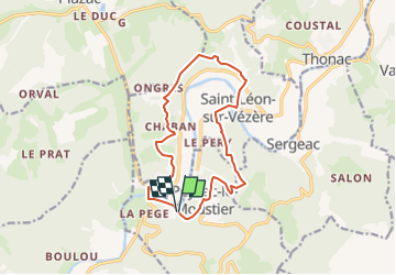
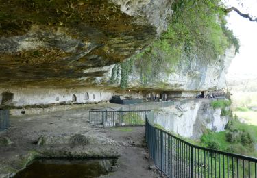
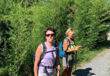
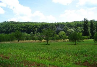
Tour Wandern von 14 km verfügbar auf Neu-Aquitanien, Dordogne, Peyzac-le-Moustier. Diese Tour wird von natacha.brion69 vorgeschlagen.
Beschreibung
Boucle au départ de La Roque St Christophe, par Peyzac le Moustier et St Léon sur Vézère
Ort
Land:
France
Region :
Neu-Aquitanien
Abteilung/Provinz :
Dordogne
Kommune :
Peyzac-le-Moustier
Standort:
Unknown
Gehen Sie:(Dec)
Gehen Sie:(UTM)
347919 ; 4983417 (31T) N.
Kommentare
Touren in der Umgebung
![Tour Wandern Marquay - Boucle château de Commarques - Photo](https://media.geolcdn.com/t/375/260/e94a54d4-ef90-4f5d-ac1f-5bce9f35b729.jpg&format=jpg&maxdim=2)
![Wandern Wandern](https://static1.geolcdn.com/sitytour/trail-icons/101.png)
Boucle château de Commarques
Wandern
Medium
Marquay,
Neu-Aquitanien,
Dordogne,
France
![](/images/other/stat-length.png)
5,1 km | 6,7 km-effort
1h 31min
![](https://static1.geolcdn.com/siteimages/upload/files/16400158638029165_repeat_loop_refresh_sync_direction_icon.png)
Ja
![Tour Elektrofahrrad Plazac - Sensei Lissac - Photo](https://media.geolcdn.com/t/375/260/ccd27d5e-9d83-44d7-a1a6-a717ab1146ce.jpg&format=jpg&maxdim=2)
![Elektrofahrrad Elektrofahrrad](https://static1.geolcdn.com/sitytour/trail-icons/205.png)
Sensei Lissac
Elektrofahrrad
Medium
Plazac,
Neu-Aquitanien,
Dordogne,
France
![](/images/other/stat-length.png)
18,7 km | 26 km-effort
2h 26min
![](https://static1.geolcdn.com/siteimages/upload/files/16400158638029165_repeat_loop_refresh_sync_direction_icon.png)
Ja
![Tour Wandern Saint-Léon-sur-Vézère - Boucle de Haute-Claire St Léon sur Vézère - Photo](https://media.geolcdn.com/t/375/260/6b8d4051-3369-48b4-85b3-aee55415b67f.jpg&format=jpg&maxdim=2)
![Wandern Wandern](https://static1.geolcdn.com/sitytour/trail-icons/101.png)
Boucle de Haute-Claire St Léon sur Vézère
Wandern
Medium
Saint-Léon-sur-Vézère,
Neu-Aquitanien,
Dordogne,
France
![](/images/other/stat-length.png)
12,3 km | 17 km-effort
3h 8min
![](https://static1.geolcdn.com/siteimages/upload/files/16400158638029165_repeat_loop_refresh_sync_direction_icon.png)
Ja
![Elektrofahrrad Elektrofahrrad](https://static1.geolcdn.com/sitytour/trail-icons/205.png)
Boucle Tursac la Vézère
Elektrofahrrad
Einfach
Tursac,
Neu-Aquitanien,
Dordogne,
France
![](/images/other/stat-length.png)
22 km | 29 km-effort
2h 54min
![](https://static1.geolcdn.com/siteimages/upload/files/16400158638029165_repeat_loop_refresh_sync_direction_icon.png)
Ja
![Tour Wandern Peyzac-le-Moustier - Sensei24. Roque saint christophe - Photo](https://media.geolcdn.com/t/375/260/91b857a2-44a5-482e-ba5b-0816305726ff.jpg&format=jpg&maxdim=2)
![Wandern Wandern](https://static1.geolcdn.com/sitytour/trail-icons/101.png)
Sensei24. Roque saint christophe
Wandern
Schwierig
Peyzac-le-Moustier,
Neu-Aquitanien,
Dordogne,
France
![](/images/other/stat-length.png)
16,2 km | 0 m-effort
4h 21min
![](https://static1.geolcdn.com/siteimages/upload/files/16400158638029165_repeat_loop_refresh_sync_direction_icon.png)
Ja
![Tour Wandern Tursac - La Borie - Photo](https://media.geolcdn.com/t/375/260/ext.jpg?maxdim=2&url=https%3A%2F%2Fservices.sitytrail.com%2FGeolivesWS%2FDownloadMedia.ashx%3FTrailID%3D799194%26Media%3Dfix__20170730174739.jpg)
![Wandern Wandern](https://static1.geolcdn.com/sitytour/trail-icons/101.png)
La Borie
Wandern
Einfach
Tursac,
Neu-Aquitanien,
Dordogne,
France
![](/images/other/stat-length.png)
11 km | 14,3 km-effort
2h 55min
![](https://static1.geolcdn.com/siteimages/upload/files/16400158638029165_repeat_loop_refresh_sync_direction_icon.png)
Ja
![Tour Wandern Tursac - la Borie - Photo](https://media.geolcdn.com/t/375/260/ext.jpg?maxdim=2&url=https%3A%2F%2Fservices.sitytrail.com%2FGeolivesWS%2FDownloadMedia.ashx%3FTrailID%3D799191%26Media%3Dfix__20170730174739.jpg)
![Wandern Wandern](https://static1.geolcdn.com/sitytour/trail-icons/101.png)
la Borie
Wandern
Einfach
Tursac,
Neu-Aquitanien,
Dordogne,
France
![](/images/other/stat-length.png)
11 km | 14,3 km-effort
2h 55min
![](https://static1.geolcdn.com/siteimages/upload/files/16400158638029165_repeat_loop_refresh_sync_direction_icon.png)
Ja
![Tour Wandern Peyzac-le-Moustier - vezere_11 - Photo](https://media.geolcdn.com/t/375/260/ext.jpg?maxdim=2&url=https%3A%2F%2Fstatic1.geolcdn.com%2Fsiteimages%2Fupload%2Ffiles%2F1553511878bg_sport_marche.png)
![Wandern Wandern](https://static1.geolcdn.com/sitytour/trail-icons/101.png)
vezere_11
Wandern
Medium
(1)
Peyzac-le-Moustier,
Neu-Aquitanien,
Dordogne,
France
![](/images/other/stat-length.png)
8 km | 11,7 km-effort
2h 26min
![](https://static1.geolcdn.com/siteimages/upload/files/16400158638029165_repeat_loop_refresh_sync_direction_icon.png)
Ja
![Tour Mountainbike Saint-Léon-sur-Vézère - Rando VTT Silex 2013 - Saint Léon sur Vézère - Photo](https://media.geolcdn.com/t/375/260/ext.jpg?maxdim=2&url=https%3A%2F%2Fservices.sitytrail.com%2FGeolivesWS%2FDownloadMedia.ashx%3FTrailID%3D317058%26Media%3D16206_6.jpg)
![Mountainbike Mountainbike](https://static1.geolcdn.com/sitytour/trail-icons/202.png)
Rando VTT Silex 2013 - Saint Léon sur Vézère
Mountainbike
Schwierig
Saint-Léon-sur-Vézère,
Neu-Aquitanien,
Dordogne,
France
![](/images/other/stat-length.png)
41 km | 54 km-effort
4h 15min
![](https://static1.geolcdn.com/siteimages/upload/files/16400158638029165_repeat_loop_refresh_sync_direction_icon.png)
Ja