![](/images/other/stat-length.png)
![Tour Wandern Saint-Maur-des-Fossés - Le sentier de la bataille de Champigny - Photo](https://media.geolcdn.com/t/1900/400/d36e66d5-8247-40ee-8916-ef3bbbc3cc49.jpg&format=pjpeg&maxdim=2)
Le sentier de la bataille de Champigny
c.chehere
Benutzer
![Länge](/images/other/stat-length.png)
Länge
17,7 km
![Maximale Höhe](https://static1.geolcdn.com/siteimages/upload/files/1508320355ic_sort_altitude_max_24dp.png)
Maximale Höhe
102 m
![Positive Höhendifferenz](https://static1.geolcdn.com/siteimages/upload/files/1508320355ic_sort_den_pos_24dp.png)
Positive Höhendifferenz
201 m
![Km-Effort](/images/other/stat-length.png)
Km-Effort
20 km
![Min. Höhe](https://static1.geolcdn.com/siteimages/upload/files/1508320355ic_sort_altitude_min_24dp.png)
Min. Höhe
32 m
![Negative Höhendifferenz](https://static1.geolcdn.com/siteimages/upload/files/1508320355ic_sort_den_neg_24dp.png)
Negative Höhendifferenz
193 m
![Boucle](https://static1.geolcdn.com/siteimages/upload/files/16400158638029165_repeat_loop_refresh_sync_direction_icon.png)
Boucle
Nein
Erstellungsdatum :
2022-08-19 06:19:28.673
Letzte Änderung :
2022-08-19 13:41:49.472
![Wandern](https://static1.geolcdn.com/sitytour/trail-icons/101.png)
4h19
Schwierigkeit : Einfach
![Scannen Sie diesen QR-Code, um die Tour in der SityTrail-Anwendung zu öffnen](https://capi.geolives.com/qq0zvz2zws4bq2lad0pu/sitytour/trails/3359978/qr.png?size=200)
Kostenlosegpshiking-Anwendung
Über SityTrail
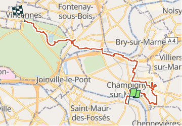
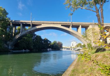
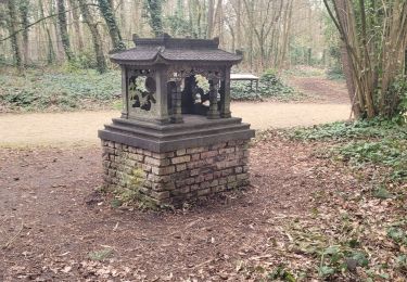
Tour Wandern von 17,7 km verfügbar auf Île-de-France, Val-de-Marne, Saint-Maur-des-Fossés. Diese Tour wird von c.chehere vorgeschlagen.
Beschreibung
De la station RER B "Champigny" jusqu'au château de Vincennes M1 en passant par Nogent et la promenade Yvette Horner
Ort
Land:
France
Region :
Île-de-France
Abteilung/Provinz :
Val-de-Marne
Kommune :
Saint-Maur-des-Fossés
Standort:
Unknown
Gehen Sie:(Dec)
Gehen Sie:(UTM)
464087 ; 5406131 (31U) N.
Kommentare
Touren in der Umgebung
![Tour Wandern Chennevières-sur-Marne - J 18 12 km Pont de Chennevières - Photo](https://media.geolcdn.com/t/375/260/6347577b-7c01-4d78-a0ab-c4e201132c35.jpg&format=jpg&maxdim=2)
![Wandern Wandern](https://static1.geolcdn.com/sitytour/trail-icons/101.png)
J 18 12 km Pont de Chennevières
Wandern
Medium
(5)
Chennevières-sur-Marne,
Île-de-France,
Val-de-Marne,
France
![](/images/other/stat-length.png)
11 km | 12 km-effort
2h 42min
![](https://static1.geolcdn.com/siteimages/upload/files/16400158638029165_repeat_loop_refresh_sync_direction_icon.png)
Ja
![Tour Wandern Neuilly-Plaisance - Neuilly Plaisance gare Rer sortie Bords de Marne/ Base Nautique Vaires sur Marne - Photo](https://media.geolcdn.com/t/375/260/3fb9e5a2-0030-4f1a-a960-e880d0c7625d.jpg&format=jpg&maxdim=2)
![Wandern Wandern](https://static1.geolcdn.com/sitytour/trail-icons/101.png)
Neuilly Plaisance gare Rer sortie Bords de Marne/ Base Nautique Vaires sur Marne
Wandern
Einfach
(1)
Neuilly-Plaisance,
Île-de-France,
Seine-Saint-Denis,
France
![](/images/other/stat-length.png)
15,9 km | 17,1 km-effort
2h 52min
![](https://static1.geolcdn.com/siteimages/upload/files/16400158638029165_repeat_loop_refresh_sync_direction_icon.png)
Ja
![Tour Wandern Noiseau - depuis Noiseau - Photo](https://media.geolcdn.com/t/375/260/ext.jpg?maxdim=2&url=https%3A%2F%2Fservices.sitytrail.com%2FGeolivesWS%2FDownloadMedia.ashx%3FTrailID%3D169363%26Media%3D20130109131150.jpeg)
![Wandern Wandern](https://static1.geolcdn.com/sitytour/trail-icons/101.png)
depuis Noiseau
Wandern
Einfach
(2)
Noiseau,
Île-de-France,
Val-de-Marne,
France
![](/images/other/stat-length.png)
17 km | 19,1 km-effort
4h 35min
![](https://static1.geolcdn.com/siteimages/upload/files/16400158638029165_repeat_loop_refresh_sync_direction_icon.png)
Ja
![Tour Wandern Saint-Maur-des-Fossés - 2025-01-08_16h55m46_de saint maur des fossés à école véterinaire au bord de la marne - Photo](https://media.geolcdn.com/t/375/260/ext.jpg?maxdim=2&url=https%3A%2F%2Fstatic1.geolcdn.com%2Fsiteimages%2Fupload%2Ffiles%2F1553511878bg_sport_marche.png)
![Wandern Wandern](https://static1.geolcdn.com/sitytour/trail-icons/101.png)
2025-01-08_16h55m46_de saint maur des fossés à école véterinaire au bord de l...
Wandern
Schwierig
(1)
Saint-Maur-des-Fossés,
Île-de-France,
Val-de-Marne,
France
![](/images/other/stat-length.png)
17,4 km | 18,9 km-effort
4h 17min
![](https://static1.geolcdn.com/siteimages/upload/files/16400158638029165_repeat_loop_refresh_sync_direction_icon.png)
Nein
![Tour Wandern Saint-Maur-des-Fossés - Randopolitain les bords de Marne 18 km - Photo](https://media.geolcdn.com/t/375/260/1f0cf9d1-3287-43b2-b3a1-db1ac230c6c3.jpg&format=jpg&maxdim=2)
![Wandern Wandern](https://static1.geolcdn.com/sitytour/trail-icons/101.png)
Randopolitain les bords de Marne 18 km
Wandern
Einfach
Saint-Maur-des-Fossés,
Île-de-France,
Val-de-Marne,
France
![](/images/other/stat-length.png)
17,2 km | 18,8 km-effort
4h 2min
![](https://static1.geolcdn.com/siteimages/upload/files/16400158638029165_repeat_loop_refresh_sync_direction_icon.png)
Nein
![Tour Zu Fuß Créteil - JC 84 - La Végétale - 18,2 km - Photo](https://media.geolcdn.com/t/375/260/ext.jpg?maxdim=2&url=https%3A%2F%2Fstatic1.geolcdn.com%2Fsiteimages%2Fupload%2Ffiles%2F1545311037marcheuse_200dpi.jpg)
![Zu Fuß Zu Fuß](https://static1.geolcdn.com/sitytour/trail-icons/100.png)
JC 84 - La Végétale - 18,2 km
Zu Fuß
Schwierig
(1)
Créteil,
Île-de-France,
Val-de-Marne,
France
![](/images/other/stat-length.png)
18,3 km | 21 km-effort
4h 40min
![](https://static1.geolcdn.com/siteimages/upload/files/16400158638029165_repeat_loop_refresh_sync_direction_icon.png)
Nein
![Tour Wandern Sucy-en-Brie - Boucle Sucy en Brie sans difficultés - Photo](https://media.geolcdn.com/t/375/260/65383356-6c0f-415e-ae66-98274ac67ff0.jpg&format=jpg&maxdim=2)
![Wandern Wandern](https://static1.geolcdn.com/sitytour/trail-icons/101.png)
Boucle Sucy en Brie sans difficultés
Wandern
Sehr leicht
Sucy-en-Brie,
Île-de-France,
Val-de-Marne,
France
![](/images/other/stat-length.png)
19,8 km | 23 km-effort
4h 26min
![](https://static1.geolcdn.com/siteimages/upload/files/16400158638029165_repeat_loop_refresh_sync_direction_icon.png)
Ja
![Tour Zu Fuß Champigny-sur-Marne - Sur les bords de Marne - Photo](https://media.geolcdn.com/t/375/260/0848a8c4-6d65-4224-9dca-3686da6f2272.jpg&format=jpg&maxdim=2)
![Zu Fuß Zu Fuß](https://static1.geolcdn.com/sitytour/trail-icons/100.png)
Sur les bords de Marne
Zu Fuß
Medium
Champigny-sur-Marne,
Île-de-France,
Val-de-Marne,
France
![](/images/other/stat-length.png)
32 km | 35 km-effort
7h 52min
![](https://static1.geolcdn.com/siteimages/upload/files/16400158638029165_repeat_loop_refresh_sync_direction_icon.png)
Ja
![Tour Wandern Saint-Maur-des-Fossés - Boucle St Maur - Vincennes - Photo](https://media.geolcdn.com/t/375/260/07d4e882-57e1-4d05-a0e2-c5807ef2ec4c.jpg&format=jpg&maxdim=2)
![Wandern Wandern](https://static1.geolcdn.com/sitytour/trail-icons/101.png)
Boucle St Maur - Vincennes
Wandern
Saint-Maur-des-Fossés,
Île-de-France,
Val-de-Marne,
France
![](/images/other/stat-length.png)
22 km | 24 km-effort
5h 32min
![](https://static1.geolcdn.com/siteimages/upload/files/16400158638029165_repeat_loop_refresh_sync_direction_icon.png)
Ja