![](/images/other/stat-length.png)
![Tour Woll - 2022-08-08_07h41m53_montagne-trekking-randonnee-lac-du-schiessrothied-depuis-le-hohneck - Photo](https://media.geolcdn.com/t/1900/400/ext.pjpeg?maxdim=2&url=https%3A%2F%2Fsecurestorage.geolives.com%2Fsitytour%2Ftrail-bg%2Fdefault.jpg)
2022-08-08_07h41m53_montagne-trekking-randonnee-lac-du-schiessrothied-depuis-le-hohneck
ACPL
Benutzer
![Länge](/images/other/stat-length.png)
![Maximale Höhe](https://static1.geolcdn.com/siteimages/upload/files/1508320355ic_sort_altitude_max_24dp.png)
![Positive Höhendifferenz](https://static1.geolcdn.com/siteimages/upload/files/1508320355ic_sort_den_pos_24dp.png)
![Km-Effort](/images/other/stat-length.png)
![Min. Höhe](https://static1.geolcdn.com/siteimages/upload/files/1508320355ic_sort_altitude_min_24dp.png)
![Negative Höhendifferenz](https://static1.geolcdn.com/siteimages/upload/files/1508320355ic_sort_den_neg_24dp.png)
![Boucle](https://static1.geolcdn.com/siteimages/upload/files/16400158638029165_repeat_loop_refresh_sync_direction_icon.png)
![Scannen Sie diesen QR-Code, um die Tour in der SityTrail-Anwendung zu öffnen](https://capi.geolives.com/qq0zvz2zws4bq2lad0pu/sitytour/trails/3346680/qr.png?size=200)
Kostenlosegpshiking-Anwendung
Über SityTrail
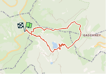
Tour von 8,8 km verfügbar auf Großer Osten, Vogesen, Woll. Diese Tour wird von ACPL vorgeschlagen.
Beschreibung
Départ au parking depuis la route des crêtes en bas du Hohneck
Lat/Lon : 48.03551/7.00748
1 / Prenez la route qui se situe a côté du restaurant â Pied du Hogneckâ pour monter au Hohneck. Puis tournez a droite pour prendre le sentier en direction du Lac de Schissrothied (balisage cercle bleu)
Lat/Lon : 48.03578/7.00798
2/ Continuez tout droit en direction de la vallée de la Wormsa, Lac du Schissrothied en suivant le balisage Triangle bleu
Lat/Lon : 48.03479/7.01079
3/ Continuez sur le sentier vers la gauche
Lat/Lon : 48.03441/7.01138
4/ Tournez a droite et suivez le triangle bleu
Lat/Lon : 48.03395/7.01601
5/ Lac du Schissrothied
Lat/Lon : 48.0287/7.02493
6/ Longer le lac du Schissrothied et prenez le GR 5 en direction du Hohneck pour atteindre lâauberge du Schissrothied (balisage rectangle rouge)
Lat/Lon : 48.02857/7.02519
7/ Continuez tout droit en direction de Schiessroth et Gashney GR5 en suivant le rectangle rouge et bleu
Lat/Lon : 48.02934/7.02704
8/ Puis tournez a gauche en direction du Schissroth GR5 (balisage rectangle rouge)
Lat/Lon : 48.02869/7.02799
9/ Une fois avoir passé lâauberge Schissrothied et la route, prenez le sentier en direction du Schallern Rothried en suivant le triangle bleu
Lat/Lon : 48.02944/7.03327
10/ Tournez a gauche et suivez le triangle bleu
Lat/Lon : 48.0364/7.03969
11/ Bifurquez vers la gauche en direction du Hohneck. Suivez le balisage rectangle rouge.
Lat/Lon : 48.03642/7.02572
12/ Source pour se ravitailler en eau
Lat/Lon : 48.03655/7.01952
13/ Vue panoramique du Hohneck
Lat/Lon : 48.03711/7.01675
14/ Arrivée au parking du pied du Hohneck
Lat/Lon : 48.03592/7.00828
Ort
Kommentare
Touren in der Umgebung
![Tour Wandern Woll - 2023-04-16 Marche Abri Lac de Blanchemer vers Lac de Lispach - Photo](https://media.geolcdn.com/t/375/260/20b642e6-a3a8-4790-bc8e-b2ad298c0408.jpg&format=jpg&maxdim=2)
![Wandern Wandern](https://static1.geolcdn.com/sitytour/trail-icons/101.png)
Wandern
![](/images/other/stat-length.png)
![](https://static1.geolcdn.com/siteimages/upload/files/16400158638029165_repeat_loop_refresh_sync_direction_icon.png)
![Tour Wandern Le Valtin - Les Rochers des Hirschsteine - Lac Vert - Photo](https://media.geolcdn.com/t/375/260/4177d9e5-d8bc-4dac-ac45-c42f01ca30d3.jpg&format=jpg&maxdim=2)
![Wandern Wandern](https://static1.geolcdn.com/sitytour/trail-icons/101.png)
Wandern
![](/images/other/stat-length.png)
![](https://static1.geolcdn.com/siteimages/upload/files/16400158638029165_repeat_loop_refresh_sync_direction_icon.png)
![Tour Wandern Woll - Kastelberg des pierres, des lacs, des panoramas magnifiques - Photo](https://media.geolcdn.com/t/375/260/cada329c-fae7-4d3f-815e-38ed5d6ce361.jpg&format=jpg&maxdim=2)
![Wandern Wandern](https://static1.geolcdn.com/sitytour/trail-icons/101.png)
Wandern
![](/images/other/stat-length.png)
![](https://static1.geolcdn.com/siteimages/upload/files/16400158638029165_repeat_loop_refresh_sync_direction_icon.png)
![Tour Wandern Le Valtin - Col de la Schlucht - Photo](https://media.geolcdn.com/t/375/260/5b598871-c43c-4378-92fe-f06bddb4af29.jpg&format=jpg&maxdim=2)
![Wandern Wandern](https://static1.geolcdn.com/sitytour/trail-icons/101.png)
Wandern
![](/images/other/stat-length.png)
![](https://static1.geolcdn.com/siteimages/upload/files/16400158638029165_repeat_loop_refresh_sync_direction_icon.png)
![Tour Wandern Le Valtin - Le Sentier des Roches - Photo](https://media.geolcdn.com/t/375/260/f2737479-0e9e-43ec-9b66-c9706dc8ef91.jpg&format=jpg&maxdim=2)
![Wandern Wandern](https://static1.geolcdn.com/sitytour/trail-icons/101.png)
Wandern
![](/images/other/stat-length.png)
![](https://static1.geolcdn.com/siteimages/upload/files/16400158638029165_repeat_loop_refresh_sync_direction_icon.png)
![Tour Wandern Woll - Lac de Lispach et sentier Dielaine - Photo](https://media.geolcdn.com/t/375/260/b54731ea-6209-4cff-b7c0-af5225a4f3ae.jpg&format=jpg&maxdim=2)
![Wandern Wandern](https://static1.geolcdn.com/sitytour/trail-icons/101.png)
Wandern
![](/images/other/stat-length.png)
![](https://static1.geolcdn.com/siteimages/upload/files/16400158638029165_repeat_loop_refresh_sync_direction_icon.png)
![Tour Wandern Stoßweier - Tour du belvedere avec le passage sur les crêtes - Photo](https://media.geolcdn.com/t/375/260/5b3c85c1-2643-45e9-9769-80e100e05dda.jpg&format=jpg&maxdim=2)
![Wandern Wandern](https://static1.geolcdn.com/sitytour/trail-icons/101.png)
Wandern
![](/images/other/stat-length.png)
![](https://static1.geolcdn.com/siteimages/upload/files/16400158638029165_repeat_loop_refresh_sync_direction_icon.png)
![Wandern Wandern](https://static1.geolcdn.com/sitytour/trail-icons/101.png)
Wandern
![](/images/other/stat-length.png)
![](https://static1.geolcdn.com/siteimages/upload/files/16400158638029165_repeat_loop_refresh_sync_direction_icon.png)
![Tour Wandern Wildenstein - Col du Bramont - Machey - Blanchemer - Photo](https://media.geolcdn.com/t/375/260/ext.jpg?maxdim=2&url=https%3A%2F%2Fservices.sitytrail.com%2FGeolivesWS%2FDownloadMedia.ashx%3FTrailID%3D450008%26Media%3Dfix__20150714143610.jpg)
![Wandern Wandern](https://static1.geolcdn.com/sitytour/trail-icons/101.png)
Wandern
![](/images/other/stat-length.png)
![](https://static1.geolcdn.com/siteimages/upload/files/16400158638029165_repeat_loop_refresh_sync_direction_icon.png)