![](/images/other/stat-length.png)
![Tour Wandern Saint-Hubert - Vesqueville - Chapelle de L'Hommal (SH10) - Photo](https://media.geolcdn.com/t/1900/400/ext.pjpeg?maxdim=2&url=https%3A%2F%2Fservices.sitytrail.com%2FGeolivesWS%2FDownloadMedia.ashx%3FTrailID%3D334434%26Media%3D24c7db59-e048-41b6-9ae7-67db2b18fe47.jpg)
Vesqueville - Chapelle de L'Hommal (SH10)
La Grande Forêt de Saint-Hubert
Randonnées de la Grande Forêt de Saint-Hubert GUIDE+
![Länge](/images/other/stat-length.png)
![Maximale Höhe](https://static1.geolcdn.com/siteimages/upload/files/1508320355ic_sort_altitude_max_24dp.png)
![Positive Höhendifferenz](https://static1.geolcdn.com/siteimages/upload/files/1508320355ic_sort_den_pos_24dp.png)
![Km-Effort](/images/other/stat-length.png)
![Min. Höhe](https://static1.geolcdn.com/siteimages/upload/files/1508320355ic_sort_altitude_min_24dp.png)
![Negative Höhendifferenz](https://static1.geolcdn.com/siteimages/upload/files/1508320355ic_sort_den_neg_24dp.png)
![Boucle](https://static1.geolcdn.com/siteimages/upload/files/16400158638029165_repeat_loop_refresh_sync_direction_icon.png)
![Kennzeichnung](https://services.sitytrail.com/GeolivesWS/DownloadMedia.ashx?TrailID=334434&Media=balise.png)
![Wandern](https://static1.geolcdn.com/sitytour/trail-icons/101.png)
1h40
Schwierigkeit : Medium
![Scannen Sie diesen QR-Code, um die Tour in der SityTrail-Anwendung zu öffnen](https://capi.geolives.com/qq0zvz2zws4bq2lad0pu/sitytour/trails/334434/qr.png?size=200)
Kostenlosegpshiking-Anwendung
Über SityTrail
Tour Wandern von 6,6 km verfügbar auf Wallonien, Luxemburg, Saint-Hubert. Diese Tour wird von La Grande Forêt de Saint-Hubert vorgeschlagen.
Beschreibung
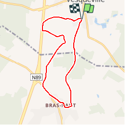
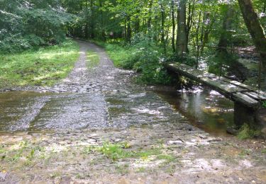
Cette balade vous offrira une vue panoramique sur le village de Vesqueville ainsi que sur la campagne qui l’entoure.
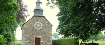
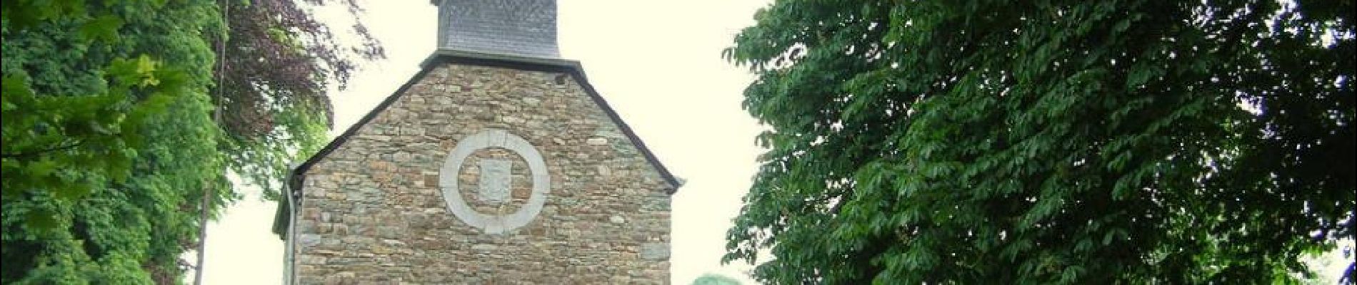
Comme son nom l’indique, elle vous emmènera jusqu’à la chapelle de Lhommal, dont la source aurait des vertus curatives pour les yeux, en passant par le village de Bras.
Extrait de la carte de promenade « Au Pays de Saint-Hubert » (30 balades pédestres, 6 circuits VTT – carte topographique 1/25.000) disponible au Royal Syndicat d’Initiative de Saint-Hubert au prix de 8€.
Royal Syndicat d’Initiative de Saint-Hubert
Place du Marché, n°15
B-6870 SAINT-HUBERT
Tél.: 32 (0)61 61 30 10
Fax: 32 (0)61 61 54 44
rsi@saint-hubert-tourisme.be
www.rsi-sainthubert.be
facebook.com/rsisainthubert
POIs
Ort
Kommentare
Touren in der Umgebung
![Tour Wandern Saint-Hubert - Saint-Hubert - La Borne (SH07) - Photo](https://media.geolcdn.com/t/375/260/ext.jpg?maxdim=2&url=https%3A%2F%2Fservices.sitytrail.com%2FGeolivesWS%2FDownloadMedia.ashx%3FTrailID%3D334588%26Media%3D91d6a6a6-ea9a-437b-8504-44eab9898f8f.JPG)
![Wandern Wandern](https://static1.geolcdn.com/sitytour/trail-icons/101.png)
Wandern
![](/images/other/stat-length.png)
![](https://static1.geolcdn.com/siteimages/upload/files/16400158638029165_repeat_loop_refresh_sync_direction_icon.png)
![Tour Wandern Saint-Hubert - Hatrival - Banalbois (SH13) - Photo](https://media.geolcdn.com/t/375/260/ext.jpg?maxdim=2&url=https%3A%2F%2Fservices.sitytrail.com%2FGeolivesWS%2FDownloadMedia.ashx%3FTrailID%3D334467%26Media%3D16828998-416a-43a0-960f-95ce479e5d6d.jpg)
![Wandern Wandern](https://static1.geolcdn.com/sitytour/trail-icons/101.png)
Wandern
![](/images/other/stat-length.png)
![](https://static1.geolcdn.com/siteimages/upload/files/16400158638029165_repeat_loop_refresh_sync_direction_icon.png)
![Wandern Wandern](https://static1.geolcdn.com/sitytour/trail-icons/101.png)
Wandern
![](/images/other/stat-length.png)
![](https://static1.geolcdn.com/siteimages/upload/files/16400158638029165_repeat_loop_refresh_sync_direction_icon.png)
![Tour Wandern Saint-Hubert - Vesqueville - Vesqueville (SH09) - Photo](https://media.geolcdn.com/t/375/260/ext.jpg?maxdim=2&url=https%3A%2F%2Fservices.sitytrail.com%2FGeolivesWS%2FDownloadMedia.ashx%3FTrailID%3D334610%26Media%3D79c980a9-bd48-4f1e-9150-6b805f1400ff.jpg)
![Wandern Wandern](https://static1.geolcdn.com/sitytour/trail-icons/101.png)
Wandern
![](/images/other/stat-length.png)
![](https://static1.geolcdn.com/siteimages/upload/files/16400158638029165_repeat_loop_refresh_sync_direction_icon.png)
![Tour Wandern Saint-Hubert - Saint-Hubert - Les Gottes (SH02) - Photo](https://media.geolcdn.com/t/375/260/ext.jpg?maxdim=2&url=https%3A%2F%2Fservices.sitytrail.com%2FGeolivesWS%2FDownloadMedia.ashx%3FTrailID%3D334532%26Media%3D483dd5de-c3cc-4d3d-acb4-87fceee0aac0.JPG)
![Wandern Wandern](https://static1.geolcdn.com/sitytour/trail-icons/101.png)
Wandern
![](/images/other/stat-length.png)
![](https://static1.geolcdn.com/siteimages/upload/files/16400158638029165_repeat_loop_refresh_sync_direction_icon.png)
![Tour Wandern Libramont-Chevigny - Marche ADEPS à Séviscourt. - Photo](https://media.geolcdn.com/t/375/260/a1af7c4b-992e-4843-a6a5-dfa52ee754c1.jpg&format=jpg&maxdim=2)
![Wandern Wandern](https://static1.geolcdn.com/sitytour/trail-icons/101.png)
Wandern
![](/images/other/stat-length.png)
![](https://static1.geolcdn.com/siteimages/upload/files/16400158638029165_repeat_loop_refresh_sync_direction_icon.png)
![Tour Wandern Saint-Hubert - ADEPS Saint Hubert - Photo](https://media.geolcdn.com/t/375/260/018b420c-08b1-4fdb-919c-55acbcd603df.jpg&format=jpg&maxdim=2)
![Wandern Wandern](https://static1.geolcdn.com/sitytour/trail-icons/101.png)
Wandern
![](/images/other/stat-length.png)
![](https://static1.geolcdn.com/siteimages/upload/files/16400158638029165_repeat_loop_refresh_sync_direction_icon.png)
![Wandern Wandern](https://static1.geolcdn.com/sitytour/trail-icons/101.png)
Wandern
![](/images/other/stat-length.png)
![](https://static1.geolcdn.com/siteimages/upload/files/16400158638029165_repeat_loop_refresh_sync_direction_icon.png)
![Wandern Wandern](https://static1.geolcdn.com/sitytour/trail-icons/101.png)
Wandern
![](/images/other/stat-length.png)
![](https://static1.geolcdn.com/siteimages/upload/files/16400158638029165_repeat_loop_refresh_sync_direction_icon.png)