![](/images/other/stat-length.png)
![Tour Wandern Valtournenche - de Crepin à Chamois puis Cheneil - Photo](https://media.geolcdn.com/t/1900/400/ext.pjpeg?maxdim=2&url=https%3A%2F%2Fstatic1.geolcdn.com%2Fsiteimages%2Fupload%2Ffiles%2F1553511878bg_sport_marche.png)
de Crepin à Chamois puis Cheneil
David Toussaint
Benutzer
![Länge](/images/other/stat-length.png)
Länge
12,5 km
![Maximale Höhe](https://static1.geolcdn.com/siteimages/upload/files/1508320355ic_sort_altitude_max_24dp.png)
Maximale Höhe
2283 m
![Positive Höhendifferenz](https://static1.geolcdn.com/siteimages/upload/files/1508320355ic_sort_den_pos_24dp.png)
Positive Höhendifferenz
953 m
![Km-Effort](/images/other/stat-length.png)
Km-Effort
24 km
![Min. Höhe](https://static1.geolcdn.com/siteimages/upload/files/1508320355ic_sort_altitude_min_24dp.png)
Min. Höhe
1484 m
![Negative Höhendifferenz](https://static1.geolcdn.com/siteimages/upload/files/1508320355ic_sort_den_neg_24dp.png)
Negative Höhendifferenz
514 m
![Boucle](https://static1.geolcdn.com/siteimages/upload/files/16400158638029165_repeat_loop_refresh_sync_direction_icon.png)
Boucle
Nein
Erstellungsdatum :
2022-07-28 08:13:31.419
Letzte Änderung :
2022-07-28 15:45:11.985
![Wandern](https://static1.geolcdn.com/sitytour/trail-icons/101.png)
5h40
Schwierigkeit : Medium
![Scannen Sie diesen QR-Code, um die Tour in der SityTrail-Anwendung zu öffnen](https://capi.geolives.com/qq0zvz2zws4bq2lad0pu/sitytour/trails/3333116/qr.png?size=200)
Kostenlosegpshiking-Anwendung
Über SityTrail
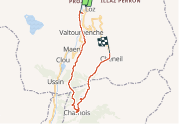
Tour Wandern von 12,5 km verfügbar auf Aostatal, Unbekannt, Valtournenche. Diese Tour wird von David Toussaint vorgeschlagen.
Beschreibung
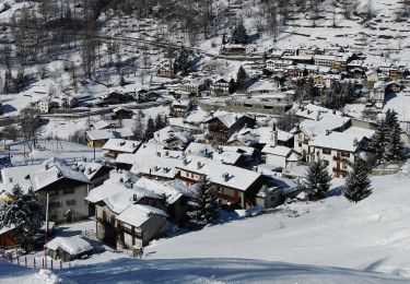
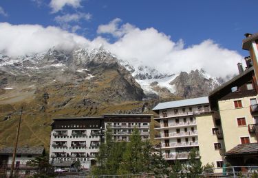
Randonner jusqu'au village de Chamois a partir de Crepin puis retour a Cheneil, rapatriement avec la navette de l'arret du funiculaire de Barmas à Cheneil jusqu'à Crepin.
Ort
Land:
Italy
Region :
Aostatal
Abteilung/Provinz :
Unbekannt
Kommune :
Valtournenche
Standort:
Unknown
Gehen Sie:(Dec)
Gehen Sie:(UTM)
393090 ; 5082353 (32T) N.
Kommentare
Touren in der Umgebung
![Tour Zu Fuß Valtournenche - Alta Via n. 1 della Valle d'Aosta - Tappa 10 - Photo](https://media.geolcdn.com/t/375/260/2d4a362f-5aa1-417e-8a6b-be0439474bd6.jpeg&format=jpg&maxdim=2)
![Zu Fuß Zu Fuß](https://static1.geolcdn.com/sitytour/trail-icons/100.png)
Alta Via n. 1 della Valle d'Aosta - Tappa 10
Zu Fuß
Schwierig
Valtournenche,
Aostatal,
Unbekannt,
Italy
![](/images/other/stat-length.png)
16,1 km | 33 km-effort
7h 24min
![](https://static1.geolcdn.com/siteimages/upload/files/16400158638029165_repeat_loop_refresh_sync_direction_icon.png)
Nein
![Tour Zu Fuß Valtournenche - Alta Via n. 1 della Valle d'Aosta - Tappa 9 - Photo](https://media.geolcdn.com/t/375/260/224941b8-ec0f-4546-9f0d-eac73fc99d3b.jpeg&format=jpg&maxdim=2)
![Zu Fuß Zu Fuß](https://static1.geolcdn.com/sitytour/trail-icons/100.png)
Alta Via n. 1 della Valle d'Aosta - Tappa 9
Zu Fuß
Einfach
Valtournenche,
Aostatal,
Unbekannt,
Italy
![](/images/other/stat-length.png)
4,5 km | 11,2 km-effort
2h 32min
![](https://static1.geolcdn.com/siteimages/upload/files/16400158638029165_repeat_loop_refresh_sync_direction_icon.png)
Nein
![Tour Zu Fuß Valtournenche - (SI F17) Valtournenche - Rifugio Grand Tournalin - Photo](https://media.geolcdn.com/t/375/260/c89ae013-b1cb-419e-9d5e-2afa09d90d27.jpeg&format=jpg&maxdim=2)
![Zu Fuß Zu Fuß](https://static1.geolcdn.com/sitytour/trail-icons/100.png)
(SI F17) Valtournenche - Rifugio Grand Tournalin
Zu Fuß
Medium
Valtournenche,
Aostatal,
Unbekannt,
Italy
![](/images/other/stat-length.png)
8,7 km | 23 km-effort
5h 13min
![](https://static1.geolcdn.com/siteimages/upload/files/16400158638029165_repeat_loop_refresh_sync_direction_icon.png)
Nein
![Tour Zu Fuß Valtournenche - (SI F16) Rifugio Barmasse - Valtournenche - Photo](https://media.geolcdn.com/t/375/260/231fe912-1f0a-4aab-8b08-e45916d0a197.jpeg&format=jpg&maxdim=2)
![Zu Fuß Zu Fuß](https://static1.geolcdn.com/sitytour/trail-icons/100.png)
(SI F16) Rifugio Barmasse - Valtournenche
Zu Fuß
Einfach
Valtournenche,
Aostatal,
Unbekannt,
Italy
![](/images/other/stat-length.png)
4,6 km | 7 km-effort
1h 34min
![](https://static1.geolcdn.com/siteimages/upload/files/16400158638029165_repeat_loop_refresh_sync_direction_icon.png)
Nein
![Tour Zu Fuß Ayas - Itinerario 4 Chamois Corgnolaz Colle Nannaz - Photo](https://media.geolcdn.com/t/375/260/51ad9c66-d8b6-4d6b-8376-6ce56c218a93.jpeg&format=jpg&maxdim=2)
![Zu Fuß Zu Fuß](https://static1.geolcdn.com/sitytour/trail-icons/100.png)
Itinerario 4 Chamois Corgnolaz Colle Nannaz
Zu Fuß
Einfach
Ayas,
Aostatal,
Unbekannt,
Italy
![](/images/other/stat-length.png)
6,7 km | 9,9 km-effort
2h 15min
![](https://static1.geolcdn.com/siteimages/upload/files/16400158638029165_repeat_loop_refresh_sync_direction_icon.png)
Nein
![Tour Zu Fuß Ayas - Itinerario 3 Chamois Col di Nannaz - Photo](https://media.geolcdn.com/t/375/260/51ad9c66-d8b6-4d6b-8376-6ce56c218a93.jpeg&format=jpg&maxdim=2)
![Zu Fuß Zu Fuß](https://static1.geolcdn.com/sitytour/trail-icons/100.png)
Itinerario 3 Chamois Col di Nannaz
Zu Fuß
Einfach
Ayas,
Aostatal,
Unbekannt,
Italy
![](/images/other/stat-length.png)
7,2 km | 10,7 km-effort
2h 26min
![](https://static1.geolcdn.com/siteimages/upload/files/16400158638029165_repeat_loop_refresh_sync_direction_icon.png)
Nein
![Tour Zu Fuß Torgnon - Gran Balconata del Cervino - Photo](https://media.geolcdn.com/t/375/260/a69bc1c0-4ec5-402c-b107-c41e1d136f1d.jpeg&format=jpg&maxdim=2)
![Zu Fuß Zu Fuß](https://static1.geolcdn.com/sitytour/trail-icons/100.png)
Gran Balconata del Cervino
Zu Fuß
Medium
Torgnon,
Aostatal,
Unbekannt,
Italy
![](/images/other/stat-length.png)
17,7 km | 30 km-effort
6h 45min
![](https://static1.geolcdn.com/siteimages/upload/files/16400158638029165_repeat_loop_refresh_sync_direction_icon.png)
Nein
![Tour Zu Fuß Ayas - Itinerario 3A Ru Cleva Bella - Photo](https://media.geolcdn.com/t/375/260/a6a4ee1d-f988-4860-928f-d2008b5c46bb.jpeg&format=jpg&maxdim=2)
![Zu Fuß Zu Fuß](https://static1.geolcdn.com/sitytour/trail-icons/100.png)
Itinerario 3A Ru Cleva Bella
Zu Fuß
Einfach
Ayas,
Aostatal,
Unbekannt,
Italy
![](/images/other/stat-length.png)
4,8 km | 6,7 km-effort
1h 31min
![](https://static1.geolcdn.com/siteimages/upload/files/16400158638029165_repeat_loop_refresh_sync_direction_icon.png)
Nein
![Tour Zu Fuß Valtournenche - Itinerario n. 2 Moulin Cortina - Photo](https://media.geolcdn.com/t/375/260/2c40cf55-6b92-499f-ad6c-4c7e582acd07.jpeg&format=jpg&maxdim=2)
![Zu Fuß Zu Fuß](https://static1.geolcdn.com/sitytour/trail-icons/100.png)
Itinerario n. 2 Moulin Cortina
Zu Fuß
Einfach
Valtournenche,
Aostatal,
Unbekannt,
Italy
![](/images/other/stat-length.png)
3,7 km | 11,4 km-effort
2h 34min
![](https://static1.geolcdn.com/siteimages/upload/files/16400158638029165_repeat_loop_refresh_sync_direction_icon.png)
Nein