![](/images/other/stat-length.png)
![Tour Wandern Cezais - collines de cezais - Photo](https://media.geolcdn.com/t/1900/400/cade275a-6153-4f19-8826-d0c426d046d7.jpg&format=pjpeg&maxdim=2)
collines de cezais
petorin
Benutzer
![Länge](/images/other/stat-length.png)
Länge
8,8 km
![Maximale Höhe](https://static1.geolcdn.com/siteimages/upload/files/1508320355ic_sort_altitude_max_24dp.png)
Maximale Höhe
122 m
![Positive Höhendifferenz](https://static1.geolcdn.com/siteimages/upload/files/1508320355ic_sort_den_pos_24dp.png)
Positive Höhendifferenz
130 m
![Km-Effort](/images/other/stat-length.png)
Km-Effort
10,6 km
![Min. Höhe](https://static1.geolcdn.com/siteimages/upload/files/1508320355ic_sort_altitude_min_24dp.png)
Min. Höhe
61 m
![Negative Höhendifferenz](https://static1.geolcdn.com/siteimages/upload/files/1508320355ic_sort_den_neg_24dp.png)
Negative Höhendifferenz
142 m
![Boucle](https://static1.geolcdn.com/siteimages/upload/files/16400158638029165_repeat_loop_refresh_sync_direction_icon.png)
Boucle
Nein
Erstellungsdatum :
2022-07-25 12:23:40.543
Letzte Änderung :
2022-07-25 14:24:51.717
![Wandern](https://static1.geolcdn.com/sitytour/trail-icons/101.png)
2h00
Schwierigkeit : Einfach
![Scannen Sie diesen QR-Code, um die Tour in der SityTrail-Anwendung zu öffnen](https://capi.geolives.com/qq0zvz2zws4bq2lad0pu/sitytour/trails/3328980/qr.png?size=200)
Kostenlosegpshiking-Anwendung
Über SityTrail
Tour Wandern von 8,8 km verfügbar auf Pays de la Loire, Vendée, Cezais. Diese Tour wird von petorin vorgeschlagen.
Beschreibung
bienvenue dans les chemins creux de Cezais avec point de vue à collines de châtaigners.
départ du terrain de foot de Cezais.
Ort
Land:
France
Region :
Pays de la Loire
Abteilung/Provinz :
Vendée
Kommune :
Cezais
Standort:
Unknown
Gehen Sie:(Dec)
Gehen Sie:(UTM)
668571 ; 5160885 (30T) N.
Kommentare
Touren in der Umgebung
![Tour Wandern Vouvant - rando du 02/082024 - Photo](https://media.geolcdn.com/t/375/260/ext.jpg?maxdim=2&url=https%3A%2F%2Fstatic1.geolcdn.com%2Fsiteimages%2Fupload%2Ffiles%2F1553511878bg_sport_marche.png)
![Wandern Wandern](https://static1.geolcdn.com/sitytour/trail-icons/101.png)
rando du 02/082024
Wandern
Sehr leicht
(1)
Vouvant,
Pays de la Loire,
Vendée,
France
![](/images/other/stat-length.png)
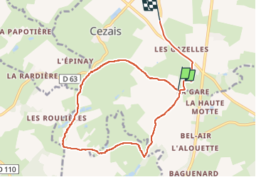
16,8 km | 21 km-effort
4h 40min
![](https://static1.geolcdn.com/siteimages/upload/files/16400158638029165_repeat_loop_refresh_sync_direction_icon.png)
Ja
![Tour Wandern Vouvant - Vouvant - Photo](https://media.geolcdn.com/t/375/260/1771e93e-e2ff-41f2-baad-f036a556c899.jpg&format=jpg&maxdim=2)
![Wandern Wandern](https://static1.geolcdn.com/sitytour/trail-icons/101.png)
![Tour Wandern Vouvant - pr vendee - Photo](https://media.geolcdn.com/t/375/260/ext.jpg?maxdim=2&url=https%3A%2F%2Fstatic1.geolcdn.com%2Fsiteimages%2Fupload%2Ffiles%2F1553511878bg_sport_marche.png)
![Wandern Wandern](https://static1.geolcdn.com/sitytour/trail-icons/101.png)
pr vendee
Wandern
Medium
(1)
Vouvant,
Pays de la Loire,
Vendée,
France
![](/images/other/stat-length.png)
16,9 km | 21 km-effort
3h 38min
![](https://static1.geolcdn.com/siteimages/upload/files/16400158638029165_repeat_loop_refresh_sync_direction_icon.png)
Ja
![Tour Wandern Vouvant - Vouvant_Cite_Medievale - Photo](https://media.geolcdn.com/t/375/260/3f2d808a-0d8b-41f6-bfd0-2bd32992224f.jpg&format=jpg&maxdim=2)
![Wandern Wandern](https://static1.geolcdn.com/sitytour/trail-icons/101.png)
Vouvant_Cite_Medievale
Wandern
Medium
Vouvant,
Pays de la Loire,
Vendée,
France
![](/images/other/stat-length.png)
15,9 km | 19,5 km-effort
4h 45min
![](https://static1.geolcdn.com/siteimages/upload/files/16400158638029165_repeat_loop_refresh_sync_direction_icon.png)
Ja
![Tour Mountainbike Antigny - La MCV des écoliers 2021 - Photo](https://media.geolcdn.com/t/375/260/1e3b5699-264a-4d5e-ba2c-7b493944d36d.jpg&format=jpg&maxdim=2)
![Mountainbike Mountainbike](https://static1.geolcdn.com/sitytour/trail-icons/202.png)
La MCV des écoliers 2021
Mountainbike
Sehr leicht
Antigny,
Pays de la Loire,
Vendée,
France
![](/images/other/stat-length.png)
36 km | 43 km-effort
3h 10min
![](https://static1.geolcdn.com/siteimages/upload/files/16400158638029165_repeat_loop_refresh_sync_direction_icon.png)
Ja
![Tour Mountainbike Cezais - boucle cezais vouvant - Photo](https://media.geolcdn.com/t/375/260/d193d496-d1fb-413f-a108-45aad5a24721.jpg&format=jpg&maxdim=2)
![Mountainbike Mountainbike](https://static1.geolcdn.com/sitytour/trail-icons/202.png)
boucle cezais vouvant
Mountainbike
Sehr leicht
Cezais,
Pays de la Loire,
Vendée,
France
![](/images/other/stat-length.png)
22 km | 26 km-effort
2h 55min
![](https://static1.geolcdn.com/siteimages/upload/files/16400158638029165_repeat_loop_refresh_sync_direction_icon.png)
Ja
![Tour Mountainbike Antigny - Antigny Mervent - Photo](https://media.geolcdn.com/t/375/260/ext.jpg?maxdim=2&url=https%3A%2F%2Fservices.sitytrail.com%2FGeolivesWS%2FDownloadMedia.ashx%3FTrailID%3D101021%26Media%3D518_1.jpg)
![Mountainbike Mountainbike](https://static1.geolcdn.com/sitytour/trail-icons/202.png)
Antigny Mervent
Mountainbike
Schwierig
Antigny,
Pays de la Loire,
Vendée,
France
![](/images/other/stat-length.png)
62 km | 74 km-effort
4h 10min
![](https://static1.geolcdn.com/siteimages/upload/files/16400158638029165_repeat_loop_refresh_sync_direction_icon.png)
Nein
![Tour Mountainbike Mervent - Boucle des Minières - Photo](https://media.geolcdn.com/t/375/260/ext.jpg?maxdim=2&url=https%3A%2F%2Fservices.sitytrail.com%2FGeolivesWS%2FDownloadMedia.ashx%3FTrailID%3D100755%26Media%3D267_2.jpg)
![Mountainbike Mountainbike](https://static1.geolcdn.com/sitytour/trail-icons/202.png)
Boucle des Minières
Mountainbike
Medium
Mervent,
Pays de la Loire,
Vendée,
France
![](/images/other/stat-length.png)
11,4 km | 13,1 km-effort
45min
![](https://static1.geolcdn.com/siteimages/upload/files/16400158638029165_repeat_loop_refresh_sync_direction_icon.png)
Ja
![Tour Mountainbike Mervent - Boucle de Pierre Brune - Photo](https://media.geolcdn.com/t/375/260/ext.jpg?maxdim=2&url=https%3A%2F%2Fservices.sitytrail.com%2FGeolivesWS%2FDownloadMedia.ashx%3FTrailID%3D100753%26Media%3D265_2.jpg)
![Mountainbike Mountainbike](https://static1.geolcdn.com/sitytour/trail-icons/202.png)
Boucle de Pierre Brune
Mountainbike
Sehr schwierig
Mervent,
Pays de la Loire,
Vendée,
France
![](/images/other/stat-length.png)
9,7 km | 13 km-effort
1h 10min
![](https://static1.geolcdn.com/siteimages/upload/files/16400158638029165_repeat_loop_refresh_sync_direction_icon.png)
Ja