![](/images/other/stat-length.png)
![Tour Wandern Valtournenche - de Pereres a Crepin - Photo](https://media.geolcdn.com/t/1900/400/ext.pjpeg?maxdim=2&url=https%3A%2F%2Fstatic1.geolcdn.com%2Fsiteimages%2Fupload%2Ffiles%2F1553511878bg_sport_marche.png)
de Pereres a Crepin
David Toussaint
Benutzer
![Länge](/images/other/stat-length.png)
![Maximale Höhe](https://static1.geolcdn.com/siteimages/upload/files/1508320355ic_sort_altitude_max_24dp.png)
![Positive Höhendifferenz](https://static1.geolcdn.com/siteimages/upload/files/1508320355ic_sort_den_pos_24dp.png)
![Km-Effort](/images/other/stat-length.png)
![Min. Höhe](https://static1.geolcdn.com/siteimages/upload/files/1508320355ic_sort_altitude_min_24dp.png)
![Negative Höhendifferenz](https://static1.geolcdn.com/siteimages/upload/files/1508320355ic_sort_den_neg_24dp.png)
![Boucle](https://static1.geolcdn.com/siteimages/upload/files/16400158638029165_repeat_loop_refresh_sync_direction_icon.png)
![Wandern](https://static1.geolcdn.com/sitytour/trail-icons/101.png)
6h40
Schwierigkeit : Medium
![Scannen Sie diesen QR-Code, um die Tour in der SityTrail-Anwendung zu öffnen](https://capi.geolives.com/qq0zvz2zws4bq2lad0pu/sitytour/trails/3327863/qr.png?size=200)
Kostenlosegpshiking-Anwendung
Über SityTrail
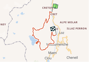
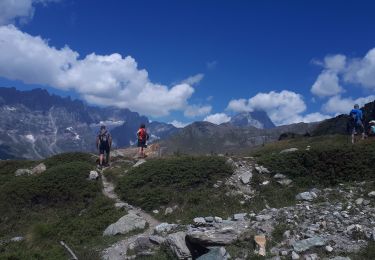
Tour Wandern von 13,6 km verfügbar auf Aostatal, Unbekannt, Valtournenche. Diese Tour wird von David Toussaint vorgeschlagen.
Beschreibung
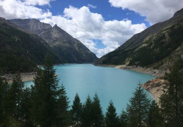
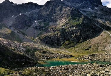
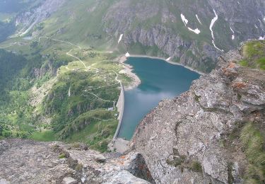
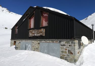
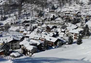
partant de Pererez au nord de Valtournenche, retour a Crepin par l'ascension avec vue imprenable sur le Cervin en arrière plan, puis passage au col et descente au lac artificiel de Cignana et refuge Barmasse, en redescente vers Cremin.
ballade pas difficile mais longue. a prendre en compte si marcheurs inexpérimentés.
Ort
Kommentare
Touren in der Umgebung
![Tour Zu Fuß Bionaz - Itinerario 11 Diga di Bionaz Alpeggio Bella Tsa - Photo](https://media.geolcdn.com/t/375/260/14365321-508a-40d1-8af3-3bc0fb3dd45d.jpeg&format=jpg&maxdim=2)
![Zu Fuß Zu Fuß](https://static1.geolcdn.com/sitytour/trail-icons/100.png)
Zu Fuß
![](/images/other/stat-length.png)
![](https://static1.geolcdn.com/siteimages/upload/files/16400158638029165_repeat_loop_refresh_sync_direction_icon.png)
![Tour Zu Fuß Valtournenche - Alta Via n. 1 della Valle d'Aosta - Tappa 10 - Photo](https://media.geolcdn.com/t/375/260/2d4a362f-5aa1-417e-8a6b-be0439474bd6.jpeg&format=jpg&maxdim=2)
![Zu Fuß Zu Fuß](https://static1.geolcdn.com/sitytour/trail-icons/100.png)
Zu Fuß
![](/images/other/stat-length.png)
![](https://static1.geolcdn.com/siteimages/upload/files/16400158638029165_repeat_loop_refresh_sync_direction_icon.png)
![Tour Zu Fuß Valtournenche - Alta Via n. 1 della Valle d'Aosta - Tappa 9 - Photo](https://media.geolcdn.com/t/375/260/224941b8-ec0f-4546-9f0d-eac73fc99d3b.jpeg&format=jpg&maxdim=2)
![Zu Fuß Zu Fuß](https://static1.geolcdn.com/sitytour/trail-icons/100.png)
Zu Fuß
![](/images/other/stat-length.png)
![](https://static1.geolcdn.com/siteimages/upload/files/16400158638029165_repeat_loop_refresh_sync_direction_icon.png)
![Tour Zu Fuß Valtournenche - (SI F17) Valtournenche - Rifugio Grand Tournalin - Photo](https://media.geolcdn.com/t/375/260/c89ae013-b1cb-419e-9d5e-2afa09d90d27.jpeg&format=jpg&maxdim=2)
![Zu Fuß Zu Fuß](https://static1.geolcdn.com/sitytour/trail-icons/100.png)
Zu Fuß
![](/images/other/stat-length.png)
![](https://static1.geolcdn.com/siteimages/upload/files/16400158638029165_repeat_loop_refresh_sync_direction_icon.png)
![Tour Zu Fuß Valtournenche - (SI F16) Rifugio Barmasse - Valtournenche - Photo](https://media.geolcdn.com/t/375/260/231fe912-1f0a-4aab-8b08-e45916d0a197.jpeg&format=jpg&maxdim=2)
![Zu Fuß Zu Fuß](https://static1.geolcdn.com/sitytour/trail-icons/100.png)
Zu Fuß
![](/images/other/stat-length.png)
![](https://static1.geolcdn.com/siteimages/upload/files/16400158638029165_repeat_loop_refresh_sync_direction_icon.png)
![Tour Zu Fuß Valtournenche - Itinerario 11 Rifugio Bobba Cervinia - Photo](https://media.geolcdn.com/t/375/260/741704ad-596e-428c-bb5e-e16e497d7baf.jpeg&format=jpg&maxdim=2)
![Zu Fuß Zu Fuß](https://static1.geolcdn.com/sitytour/trail-icons/100.png)
Zu Fuß
![](/images/other/stat-length.png)
![](https://static1.geolcdn.com/siteimages/upload/files/16400158638029165_repeat_loop_refresh_sync_direction_icon.png)
![Tour Zu Fuß Valtournenche - Itinerario 17 Breuil/Cervinia-Bec Pio Merlo - Photo](https://media.geolcdn.com/t/375/260/228c088b-20d2-4c98-bbe2-9649825d1741.jpeg&format=jpg&maxdim=2)
![Zu Fuß Zu Fuß](https://static1.geolcdn.com/sitytour/trail-icons/100.png)
Zu Fuß
![](/images/other/stat-length.png)
![](https://static1.geolcdn.com/siteimages/upload/files/16400158638029165_repeat_loop_refresh_sync_direction_icon.png)
![Tour Zu Fuß Valtournenche - Itinerario n. 2 Moulin Cortina - Photo](https://media.geolcdn.com/t/375/260/2c40cf55-6b92-499f-ad6c-4c7e582acd07.jpeg&format=jpg&maxdim=2)
![Zu Fuß Zu Fuß](https://static1.geolcdn.com/sitytour/trail-icons/100.png)
Zu Fuß
![](/images/other/stat-length.png)
![](https://static1.geolcdn.com/siteimages/upload/files/16400158638029165_repeat_loop_refresh_sync_direction_icon.png)
![Tour Wandern Valtournenche - Cheneil a Crepin via lago Doz - Photo](https://media.geolcdn.com/t/375/260/2cece5f6-4773-4805-a531-d87950980d99.jpg&format=jpg&maxdim=2)
![Wandern Wandern](https://static1.geolcdn.com/sitytour/trail-icons/101.png)
Wandern
![](/images/other/stat-length.png)
![](https://static1.geolcdn.com/siteimages/upload/files/16400158638029165_repeat_loop_refresh_sync_direction_icon.png)