![](/images/other/stat-length.png)
![Tour Wandern Bagnères-de-Bigorre - etg bleu-col de bareille-pic bizoutère-lac d'Ourec depuis le Chiroulet - Photo](https://media.geolcdn.com/t/1900/400/20e9c13b-1617-4d8b-b37e-de95ee0ebc15.jpg&format=pjpeg&maxdim=2)
etg bleu-col de bareille-pic bizoutère-lac d'Ourec depuis le Chiroulet
chrisgps
Benutzer
![Länge](/images/other/stat-length.png)
![Maximale Höhe](https://static1.geolcdn.com/siteimages/upload/files/1508320355ic_sort_altitude_max_24dp.png)
![Positive Höhendifferenz](https://static1.geolcdn.com/siteimages/upload/files/1508320355ic_sort_den_pos_24dp.png)
![Km-Effort](/images/other/stat-length.png)
![Min. Höhe](https://static1.geolcdn.com/siteimages/upload/files/1508320355ic_sort_altitude_min_24dp.png)
![Negative Höhendifferenz](https://static1.geolcdn.com/siteimages/upload/files/1508320355ic_sort_den_neg_24dp.png)
![Boucle](https://static1.geolcdn.com/siteimages/upload/files/16400158638029165_repeat_loop_refresh_sync_direction_icon.png)
![Wandern](https://static1.geolcdn.com/sitytour/trail-icons/101.png)
7h42
Schwierigkeit : Medium
![Scannen Sie diesen QR-Code, um die Tour in der SityTrail-Anwendung zu öffnen](https://capi.geolives.com/qq0zvz2zws4bq2lad0pu/sitytour/trails/3324755/qr.png?size=200)
Kostenlosegpshiking-Anwendung
Über SityTrail
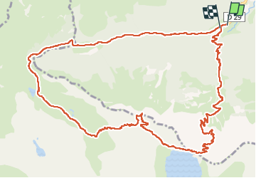
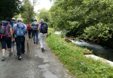
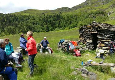
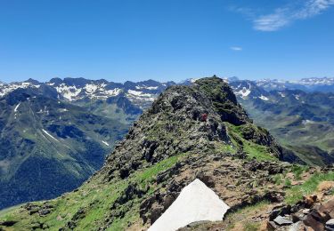
Tour Wandern von 16 km verfügbar auf Okzitanien, Hautes-Pyrénées, Bagnères-de-Bigorre. Diese Tour wird von chrisgps vorgeschlagen.
Beschreibung
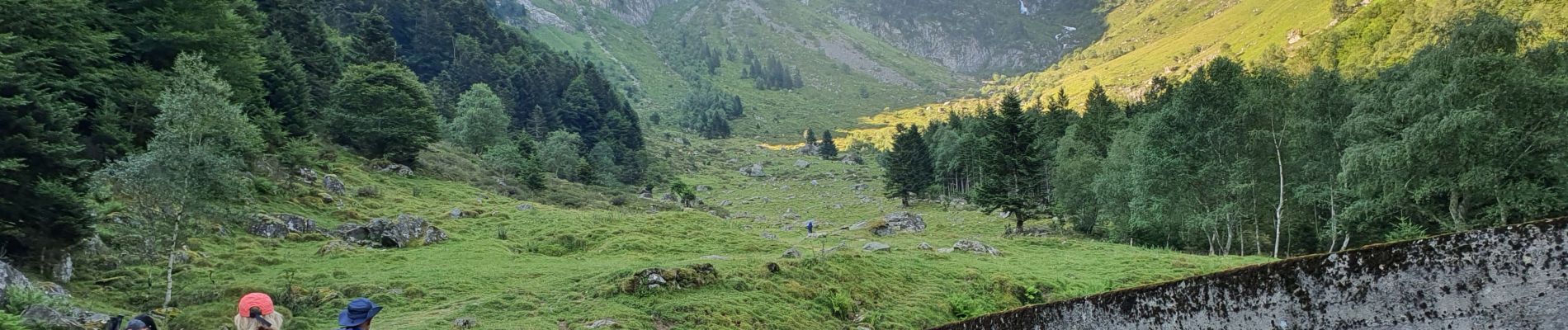
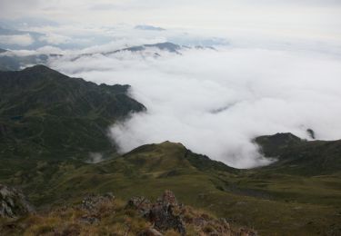
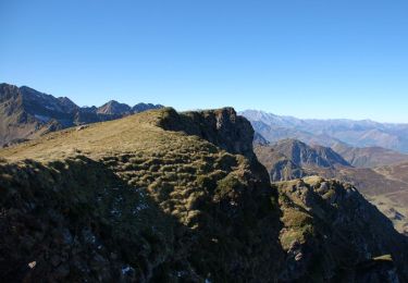
Beau circuit et beaux panoramas.
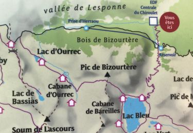
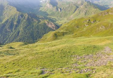
Sur le sentier vers le col de Bareille, on a bifurqué mais trop à droite... il faut "monter" en zigzagant jusqu'à la crête qui mène au Pic de Bizourtère. Et le Bizourtère, c'est le 2ème petit sommet marqué par un cairn à son nom !
Ort
Kommentare
Touren in der Umgebung
![Tour Wandern Bagnères-de-Bigorre - Le pic de Montaigu - Photo](https://media.geolcdn.com/t/375/260/ext.jpg?maxdim=2&url=https%3A%2F%2Fservices.sitytrail.com%2FGeolivesWS%2FDownloadMedia.ashx%3FTrailID%3D105593%26Media%3D9362_6.jpg)
![Wandern Wandern](https://static1.geolcdn.com/sitytour/trail-icons/101.png)
Wandern
![](/images/other/stat-length.png)
![](https://static1.geolcdn.com/siteimages/upload/files/16400158638029165_repeat_loop_refresh_sync_direction_icon.png)
![Tour Wandern Bagnères-de-Bigorre - Lac Bleu et pic de Bizourtère (2311m) - Photo](https://media.geolcdn.com/t/375/260/ext.jpg?maxdim=2&url=https%3A%2F%2Fservices.sitytrail.com%2FGeolivesWS%2FDownloadMedia.ashx%3FTrailID%3D109966%26Media%3D5045_1.jpg)
![Wandern Wandern](https://static1.geolcdn.com/sitytour/trail-icons/101.png)
Wandern
![](/images/other/stat-length.png)
![](https://static1.geolcdn.com/siteimages/upload/files/16400158638029165_repeat_loop_refresh_sync_direction_icon.png)
![Tour Wandern Beaudéan - LESPONNE entre torrents et cascades (G3) fait le 17 Juillet 2020](https://media.geolcdn.com/t/375/260/e61486eb-19e7-488b-bc78-39d6109d1c0c.jpg&format=jpg&maxdim=2)
![Wandern Wandern](https://static1.geolcdn.com/sitytour/trail-icons/101.png)
Wandern
![](/images/other/stat-length.png)
![](https://static1.geolcdn.com/siteimages/upload/files/16400158638029165_repeat_loop_refresh_sync_direction_icon.png)
![Tour Wandern Bagnères-de-Bigorre - LESPONNE courtaou de la lit G3 B fait le 12/06/2020 - Photo](https://media.geolcdn.com/t/375/260/4992e91a-d5e6-4bdf-b8d5-1942787e9e14.jpg&format=jpg&maxdim=2)
![Wandern Wandern](https://static1.geolcdn.com/sitytour/trail-icons/101.png)
Wandern
![](/images/other/stat-length.png)
![](https://static1.geolcdn.com/siteimages/upload/files/16400158638029165_repeat_loop_refresh_sync_direction_icon.png)
![Tour Wandern Bagnères-de-Bigorre - Le lac bleu et le lac outrec - Photo](https://media.geolcdn.com/t/375/260/9bb915d4-d98b-4d7b-8268-4bf841ab3648.jpg&format=jpg&maxdim=2)
![Wandern Wandern](https://static1.geolcdn.com/sitytour/trail-icons/101.png)
Wandern
![](/images/other/stat-length.png)
![](https://static1.geolcdn.com/siteimages/upload/files/16400158638029165_repeat_loop_refresh_sync_direction_icon.png)
![Tour Wandern Beaucens - Retour voiture 28 juin 2023 hautacam - Photo](https://media.geolcdn.com/t/375/260/7561a025-8206-4fa3-858a-efbfd31b3c91.jpg&format=jpg&maxdim=2)
![Wandern Wandern](https://static1.geolcdn.com/sitytour/trail-icons/101.png)
Wandern
![](/images/other/stat-length.png)
![](https://static1.geolcdn.com/siteimages/upload/files/16400158638029165_repeat_loop_refresh_sync_direction_icon.png)
![Tour Wandern Bagnères-de-Bigorre - Le montaigu - Photo](https://media.geolcdn.com/t/375/260/0d2a2a6a-e1bd-4469-8cd9-e542097178ef.jpg&format=jpg&maxdim=2)
![Wandern Wandern](https://static1.geolcdn.com/sitytour/trail-icons/101.png)
Wandern
![](/images/other/stat-length.png)
![](https://static1.geolcdn.com/siteimages/upload/files/16400158638029165_repeat_loop_refresh_sync_direction_icon.png)
![Tour Zu Fuß Bagnères-de-Bigorre - Le Lac de Peyrelade - Photo](https://media.geolcdn.com/t/375/260/10280883-3cab-4fda-b05f-7ebda7eb59e5.jpeg&format=jpg&maxdim=2)
![Zu Fuß Zu Fuß](https://static1.geolcdn.com/sitytour/trail-icons/100.png)
Zu Fuß
![](/images/other/stat-length.png)
![](https://static1.geolcdn.com/siteimages/upload/files/16400158638029165_repeat_loop_refresh_sync_direction_icon.png)
![Tour Wandern Bagnères-de-Bigorre - Le Cap de Labasset et le lac de Peyrelade - Photo](https://media.geolcdn.com/t/375/260/ext.jpg?maxdim=2&url=https%3A%2F%2Fservices.sitytrail.com%2FGeolivesWS%2FDownloadMedia.ashx%3FTrailID%3D316843%26Media%3D15908_6.jpg)
![Wandern Wandern](https://static1.geolcdn.com/sitytour/trail-icons/101.png)
Wandern
![](/images/other/stat-length.png)
![](https://static1.geolcdn.com/siteimages/upload/files/16400158638029165_repeat_loop_refresh_sync_direction_icon.png)