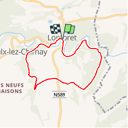
![](/images/other/stat-length.png)
Chimay (08) - Spaziergang am Eau Blanche
La Forêt du Pays de Chimay
Randonnées au coeur d'une nature préservée GUIDE+
![Länge](/images/other/stat-length.png)
![Maximale Höhe](https://static1.geolcdn.com/siteimages/upload/files/1508320355ic_sort_altitude_max_24dp.png)
![Positive Höhendifferenz](https://static1.geolcdn.com/siteimages/upload/files/1508320355ic_sort_den_pos_24dp.png)
![Km-Effort](/images/other/stat-length.png)
![Min. Höhe](https://static1.geolcdn.com/siteimages/upload/files/1508320355ic_sort_altitude_min_24dp.png)
![Negative Höhendifferenz](https://static1.geolcdn.com/siteimages/upload/files/1508320355ic_sort_den_neg_24dp.png)
![Boucle](https://static1.geolcdn.com/siteimages/upload/files/16400158638029165_repeat_loop_refresh_sync_direction_icon.png)
![Wandern](https://static1.geolcdn.com/sitytour/trail-icons/101.png)
1h40
Schwierigkeit : Unbekannt
![Scannen Sie diesen QR-Code, um die Tour in der SityTrail-Anwendung zu öffnen](https://capi.geolives.com/qq0zvz2zws4bq2lad0pu/sitytour/trails/331868/qr.png?size=200)
Kostenlosegpshiking-Anwendung
Über SityTrail
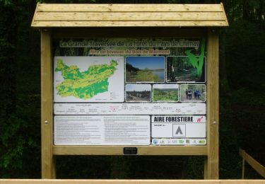
Tour Wandern von 6,3 km verfügbar auf Wallonien, Hennegau, Chimay. Diese Tour wird von La Forêt du Pays de Chimay vorgeschlagen.
Beschreibung
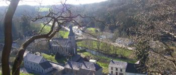
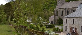
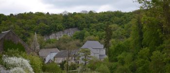
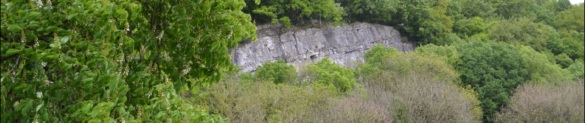
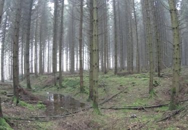
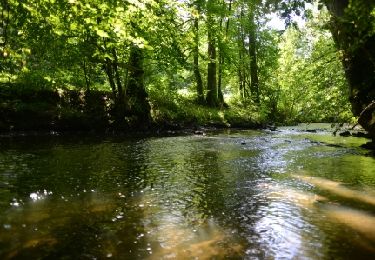
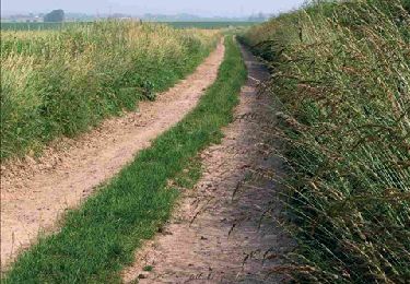
Tal der Flüsse ?Eau Blanche? und ?Eau Noire?: Das ?Pays?, das Sie durchwandern, besitzt eine Vielzahl an Quellen und Bächen, die gemeinsam die beiden Täler unserer Region speisen: das Vallée de l?Eau Blanche und das Vallée de l?Eau Noire. Die Merkmale beider Flüsse stammen aus dem Untergrund, in den sie sich jeweils ihr Bett gegraben haben. Der Fluss ?Eau Blanche? (Weißes Wasser) hat durch das Kalk im Boden ein weißliches Wasser. Der Fluss ?Eau Noire? (Schwarzes Wasser) hat durch den schieferhaltigen Boden eine dunklere Farbe. Beide Flüsse treffen sich in Nismes (Richtung Couvin) und vereinen sich zum Fluss Viroin, der in die Meuse in Frankreich fließt. Angler sollten daran denken, dass die Flüsse teilweise privatisierte Bereiche haben.
POIs
Ort
Kommentare
Touren in der Umgebung
![Tour Wandern Chimay - Chimay (06) - Spaziergang im Wald von Blaimont - Photo](https://media.geolcdn.com/t/375/260/ext.jpg?maxdim=2&url=https%3A%2F%2Fservices.sitytrail.com%2FGeolivesWS%2FDownloadMedia.ashx%3FTrailID%3D331824%26Media%3D01711463-3f95-4467-bc70-342d1207f062.jpg)
![Wandern Wandern](https://static1.geolcdn.com/sitytour/trail-icons/101.png)
Wandern
![](/images/other/stat-length.png)
![](https://static1.geolcdn.com/siteimages/upload/files/16400158638029165_repeat_loop_refresh_sync_direction_icon.png)
![Tour Wandern Chimay - RB-HA-11 - Aux portes du chef-lieu: un Borinage inattendu! - Photo](https://media.geolcdn.com/t/375/260/ext.jpg?maxdim=2&url=https%3A%2F%2Fservices.sitytrail.com%2FGeolivesWS%2FDownloadMedia.ashx%3FTrailID%3D179605%26Media%3Df9b6b0bc-2e2b-4d60-835d-c18f5a5aba68.jpg)
![Wandern Wandern](https://static1.geolcdn.com/sitytour/trail-icons/101.png)
Wandern
![](/images/other/stat-length.png)
![](https://static1.geolcdn.com/siteimages/upload/files/16400158638029165_repeat_loop_refresh_sync_direction_icon.png)
![Tour Wandern Chimay - Chimay (12) - La Spaziergang in den Großen Wäldern - Photo](https://media.geolcdn.com/t/375/260/ext.jpg?maxdim=2&url=https%3A%2F%2Fstatic1.geolcdn.com%2Fsiteimages%2Fupload%2Ffiles%2F1553511878bg_sport_marche.png)
![Wandern Wandern](https://static1.geolcdn.com/sitytour/trail-icons/101.png)
Wandern
![](/images/other/stat-length.png)
![](https://static1.geolcdn.com/siteimages/upload/files/16400158638029165_repeat_loop_refresh_sync_direction_icon.png)
![Tour Wandern Couvin - RB-Na-27_Entre Eau Blanche et Eau Noire - Photo](https://media.geolcdn.com/t/375/260/31d58e74-eca9-4391-a48f-1c05f2d409c1.jpg&format=jpg&maxdim=2)
![Wandern Wandern](https://static1.geolcdn.com/sitytour/trail-icons/101.png)
Wandern
![](/images/other/stat-length.png)
![](https://static1.geolcdn.com/siteimages/upload/files/16400158638029165_repeat_loop_refresh_sync_direction_icon.png)
![Tour Wandern Couvin - De Presgaux à Brûly-de-Pesche - Photo](https://media.geolcdn.com/t/375/260/ext.jpg?maxdim=2&url=https%3A%2F%2Fservices.sitytrail.com%2FGeolivesWS%2FDownloadMedia.ashx%3FTrailID%3D898028%26Media%3D6e8bfb5c-e225-4bdb-a6f3-69d09b53e823.jpg)
![Wandern Wandern](https://static1.geolcdn.com/sitytour/trail-icons/101.png)
Wandern
![](/images/other/stat-length.png)
![](https://static1.geolcdn.com/siteimages/upload/files/16400158638029165_repeat_loop_refresh_sync_direction_icon.png)
![Tour Wandern Chimay - Lompret - Circuit Natura 2000, des sites qui valent le détour - Ht 4 - Photo](https://media.geolcdn.com/t/375/260/ext.jpg?maxdim=2&url=https%3A%2F%2Fservices.sitytrail.com%2FGeolivesWS%2FDownloadMedia.ashx%3FTrailID%3D331899%26Media%3D133648ad-1082-4f11-ab13-40f57a8ba97a.jpg)
![Wandern Wandern](https://static1.geolcdn.com/sitytour/trail-icons/101.png)
Wandern
![](/images/other/stat-length.png)
![](https://static1.geolcdn.com/siteimages/upload/files/16400158638029165_repeat_loop_refresh_sync_direction_icon.png)
![Tour Wandern Chimay - Bois de Blaimont - Circuit Natura 2000, des sites qui valent le détour - Ht3 - Photo](https://media.geolcdn.com/t/375/260/ext.jpg?maxdim=2&url=https%3A%2F%2Fservices.sitytrail.com%2FGeolivesWS%2FDownloadMedia.ashx%3FTrailID%3D331895%26Media%3D91ae76a6-2864-4fd2-8fd1-01f400a8909a.JPG)
![Wandern Wandern](https://static1.geolcdn.com/sitytour/trail-icons/101.png)
Wandern
![](/images/other/stat-length.png)
![](https://static1.geolcdn.com/siteimages/upload/files/16400158638029165_repeat_loop_refresh_sync_direction_icon.png)
![Tour Wandern Chimay - Balade autour des étangs de Virelles - Photo](https://media.geolcdn.com/t/375/260/ext.jpg?maxdim=2&url=https%3A%2F%2Fservices.sitytrail.com%2FGeolivesWS%2FDownloadMedia.ashx%3FTrailID%3D302606%26Media%3Df18bc5a8-5ba3-468e-960e-1cb08ce97111.JPG)
![Wandern Wandern](https://static1.geolcdn.com/sitytour/trail-icons/101.png)
Wandern
![](/images/other/stat-length.png)
![](https://static1.geolcdn.com/siteimages/upload/files/16400158638029165_repeat_loop_refresh_sync_direction_icon.png)
![Tour Wandern Chimay - RB-HA-11 – Raccourci - Aux portes du chef-lieu: un Borinage inattendu! - Photo](https://media.geolcdn.com/t/375/260/ext.jpg?maxdim=2&url=https%3A%2F%2Fservices.sitytrail.com%2FGeolivesWS%2FDownloadMedia.ashx%3FTrailID%3D219266%26Media%3D37a28fa5-218d-46d3-9460-59ecc01edbfe.jpg)
![Wandern Wandern](https://static1.geolcdn.com/sitytour/trail-icons/101.png)
Wandern
![](/images/other/stat-length.png)
![](https://static1.geolcdn.com/siteimages/upload/files/16400158638029165_repeat_loop_refresh_sync_direction_icon.png)