![](/images/other/stat-length.png)
zarautz getaria
henribatut
Benutzer
![Länge](/images/other/stat-length.png)
Länge
14,4 km
![Maximale Höhe](https://static1.geolcdn.com/siteimages/upload/files/1508320355ic_sort_altitude_max_24dp.png)
Maximale Höhe
262 m
![Positive Höhendifferenz](https://static1.geolcdn.com/siteimages/upload/files/1508320355ic_sort_den_pos_24dp.png)
Positive Höhendifferenz
479 m
![Km-Effort](/images/other/stat-length.png)
Km-Effort
21 km
![Min. Höhe](https://static1.geolcdn.com/siteimages/upload/files/1508320355ic_sort_altitude_min_24dp.png)
Min. Höhe
11 m
![Negative Höhendifferenz](https://static1.geolcdn.com/siteimages/upload/files/1508320355ic_sort_den_neg_24dp.png)
Negative Höhendifferenz
478 m
![Boucle](https://static1.geolcdn.com/siteimages/upload/files/16400158638029165_repeat_loop_refresh_sync_direction_icon.png)
Boucle
Ja
Erstellungsdatum :
2022-07-07 08:45:43.635
Letzte Änderung :
2022-07-07 17:46:46.449
![Wandern](https://static1.geolcdn.com/sitytour/trail-icons/101.png)
4h00
Schwierigkeit : Einfach
![Scannen Sie diesen QR-Code, um die Tour in der SityTrail-Anwendung zu öffnen](https://capi.geolives.com/qq0zvz2zws4bq2lad0pu/sitytour/trails/3308102/qr.png?size=200)
Kostenlosegpshiking-Anwendung
Über SityTrail
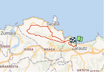
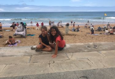
Tour Wandern von 14,4 km verfügbar auf Autonome Gemeinschaft Baskenland, Gipuzkoa, Zarautz. Diese Tour wird von henribatut vorgeschlagen.
Beschreibung
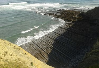
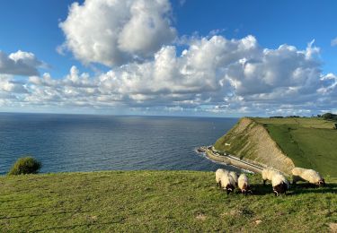
fait le 7 juillet 2022 rando très agréable en balcon sur l' ocean et Getaria. Sur bon Chemins 2 kms après Getaria sur petite route peux fréquentée. Possibilité à Getaria de revenir sur Zarautz par chemin le long de la route au dessus de la mer
Ort
Land:
Spain
Region :
Autonome Gemeinschaft Baskenland
Abteilung/Provinz :
Gipuzkoa
Kommune :
Zarautz
Standort:
Unknown
Gehen Sie:(Dec)
Gehen Sie:(UTM)
566794 ; 4792906 (30T) N.
Kommentare
Touren in der Umgebung
![Tour Zu Fuß Aia - SL-GI 4001 PAGOETA Agorregi: burnia eta ura - Photo](https://media.geolcdn.com/t/375/260/07f817b8-a8c4-417a-a39c-7c994ef7778f.jpeg&format=jpg&maxdim=2)
![Zu Fuß Zu Fuß](https://static1.geolcdn.com/sitytour/trail-icons/100.png)
SL-GI 4001 PAGOETA Agorregi: burnia eta ura
Zu Fuß
Einfach
Aia,
Autonome Gemeinschaft Baskenland,
Gipuzkoa,
Spain
![](/images/other/stat-length.png)
3,6 km | 5,4 km-effort
1h 14min
![](https://static1.geolcdn.com/siteimages/upload/files/16400158638029165_repeat_loop_refresh_sync_direction_icon.png)
Ja
![Tour Wandern Zarautz - G4 getaria - Photo](https://media.geolcdn.com/t/375/260/48db115b-22eb-4104-8f5f-3ebc9e40ba1c.jpg&format=jpg&maxdim=2)
![Wandern Wandern](https://static1.geolcdn.com/sitytour/trail-icons/101.png)
G4 getaria
Wandern
Medium
Zarautz,
Autonome Gemeinschaft Baskenland,
Gipuzkoa,
Spain
![](/images/other/stat-length.png)
5,9 km | 7,7 km-effort
3h 0min
![](https://static1.geolcdn.com/siteimages/upload/files/16400158638029165_repeat_loop_refresh_sync_direction_icon.png)
Nein
![Tour Zu Fuß Aia - SL-GI 4002 PAGOETA Faunaren ibilbidea - Photo](https://media.geolcdn.com/t/375/260/75c8baa6-c83c-40ba-87d1-b9980fb1f332.jpeg&format=jpg&maxdim=2)
![Zu Fuß Zu Fuß](https://static1.geolcdn.com/sitytour/trail-icons/100.png)
SL-GI 4002 PAGOETA Faunaren ibilbidea
Zu Fuß
Einfach
Aia,
Autonome Gemeinschaft Baskenland,
Gipuzkoa,
Spain
![](/images/other/stat-length.png)
6,2 km | 9,4 km-effort
2h 8min
![](https://static1.geolcdn.com/siteimages/upload/files/16400158638029165_repeat_loop_refresh_sync_direction_icon.png)
Ja
![Tour Wandern Zarautz - Txakoli - Photo](https://media.geolcdn.com/t/375/260/ext.jpg?maxdim=2&url=https%3A%2F%2Fservices.sitytrail.com%2FGeolivesWS%2FDownloadMedia.ashx%3FTrailID%3D646839%26Media%3D20161016110141.jpg)
![Wandern Wandern](https://static1.geolcdn.com/sitytour/trail-icons/101.png)
Txakoli
Wandern
Einfach
Zarautz,
Autonome Gemeinschaft Baskenland,
Gipuzkoa,
Spain
![](/images/other/stat-length.png)
18 km | 27 km-effort
3h 6min
![](https://static1.geolcdn.com/siteimages/upload/files/16400158638029165_repeat_loop_refresh_sync_direction_icon.png)
Ja
![Tour Wandern Getaria - JFT YB Étape 26 24-5-2014 - Photo](https://media.geolcdn.com/t/375/260/ext.jpg?maxdim=2&url=https%3A%2F%2Fservices.sitytrail.com%2FGeolivesWS%2FDownloadMedia.ashx%3FTrailID%3D304855%26Media%3Dfix__20140524104124.jpg)
![Wandern Wandern](https://static1.geolcdn.com/sitytour/trail-icons/101.png)
JFT YB Étape 26 24-5-2014
Wandern
Einfach
Getaria,
Autonome Gemeinschaft Baskenland,
Gipuzkoa,
Spain
![](/images/other/stat-length.png)
18 km | 28 km-effort
5h 7min
![](https://static1.geolcdn.com/siteimages/upload/files/16400158638029165_repeat_loop_refresh_sync_direction_icon.png)
Nein
![Tour Wandern Getaria - Zumaia - Photo](https://media.geolcdn.com/t/375/260/b8fda268-989f-4b28-a0e2-5b9b7a80af56.jpg&format=jpg&maxdim=2)
![Wandern Wandern](https://static1.geolcdn.com/sitytour/trail-icons/101.png)
Zumaia
Wandern
Schwierig
Getaria,
Autonome Gemeinschaft Baskenland,
Gipuzkoa,
Spain
![](/images/other/stat-length.png)
8,7 km | 12,1 km-effort
2h 22min
![](https://static1.geolcdn.com/siteimages/upload/files/16400158638029165_repeat_loop_refresh_sync_direction_icon.png)
Ja
![Tour Wandern Getaria - Getaria zaraost - Photo](https://media.geolcdn.com/t/375/260/adda4d22-c241-4bc8-8254-22dd46679f93.jpg&format=jpg&maxdim=2)
![Wandern Wandern](https://static1.geolcdn.com/sitytour/trail-icons/101.png)
Getaria zaraost
Wandern
Getaria,
Autonome Gemeinschaft Baskenland,
Gipuzkoa,
Spain
![](/images/other/stat-length.png)
11,4 km | 15 km-effort
6h 32min
![](https://static1.geolcdn.com/siteimages/upload/files/16400158638029165_repeat_loop_refresh_sync_direction_icon.png)
Ja
![Tour Wandern Orio - Orio-Deba - Photo](https://media.geolcdn.com/t/375/260/ext.jpg?maxdim=2&url=https%3A%2F%2Fstatic1.geolcdn.com%2Fsiteimages%2Fupload%2Ffiles%2F1553511878bg_sport_marche.png)
![Wandern Wandern](https://static1.geolcdn.com/sitytour/trail-icons/101.png)
Orio-Deba
Wandern
Schwierig
Orio,
Autonome Gemeinschaft Baskenland,
Gipuzkoa,
Spain
![](/images/other/stat-length.png)
30 km | 41 km-effort
8h 45min
![](https://static1.geolcdn.com/siteimages/upload/files/16400158638029165_repeat_loop_refresh_sync_direction_icon.png)
Nein
![Tour Wandern Getaria - 003 Getaria - Ibiri - Photo](https://media.geolcdn.com/t/375/260/ext.jpg?maxdim=2&url=https%3A%2F%2Fstatic1.geolcdn.com%2Fsiteimages%2Fupload%2Ffiles%2F1553511878bg_sport_marche.png)
![Wandern Wandern](https://static1.geolcdn.com/sitytour/trail-icons/101.png)
003 Getaria - Ibiri
Wandern
Sehr schwierig
Getaria,
Autonome Gemeinschaft Baskenland,
Gipuzkoa,
Spain
![](/images/other/stat-length.png)
19,2 km | 31 km-effort
6h 26min
![](https://static1.geolcdn.com/siteimages/upload/files/16400158638029165_repeat_loop_refresh_sync_direction_icon.png)
Nein