![](/images/other/stat-length.png)
![Tour Wandern Burscheid - Escapardenne Lee Trail: Moulin de Bourscheid - Hoscheid - Photo](https://media.geolcdn.com/t/1900/400/d49b1826-4b3a-4793-bf5a-6d813972bfaf.jpeg&format=pjpeg&maxdim=2)
Escapardenne Lee Trail: Moulin de Bourscheid - Hoscheid
dauzata
Benutzer
![Länge](/images/other/stat-length.png)
Länge
19,2 km
![Maximale Höhe](https://static1.geolcdn.com/siteimages/upload/files/1508320355ic_sort_altitude_max_24dp.png)
Maximale Höhe
504 m
![Positive Höhendifferenz](https://static1.geolcdn.com/siteimages/upload/files/1508320355ic_sort_den_pos_24dp.png)
Positive Höhendifferenz
889 m
![Km-Effort](/images/other/stat-length.png)
Km-Effort
30 km
![Min. Höhe](https://static1.geolcdn.com/siteimages/upload/files/1508320355ic_sort_altitude_min_24dp.png)
Min. Höhe
218 m
![Negative Höhendifferenz](https://static1.geolcdn.com/siteimages/upload/files/1508320355ic_sort_den_neg_24dp.png)
Negative Höhendifferenz
628 m
![Boucle](https://static1.geolcdn.com/siteimages/upload/files/16400158638029165_repeat_loop_refresh_sync_direction_icon.png)
Boucle
Nein
Erstellungsdatum :
2022-07-07 07:42:28.0
Letzte Änderung :
2022-07-25 14:39:17.333
![Wandern](https://static1.geolcdn.com/sitytour/trail-icons/101.png)
5h21
Schwierigkeit : Schwierig
![Scannen Sie diesen QR-Code, um die Tour in der SityTrail-Anwendung zu öffnen](https://capi.geolives.com/qq0zvz2zws4bq2lad0pu/sitytour/trails/3307900/qr.png?size=200)
Kostenlosegpshiking-Anwendung
Über SityTrail
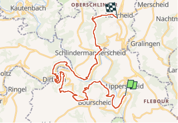
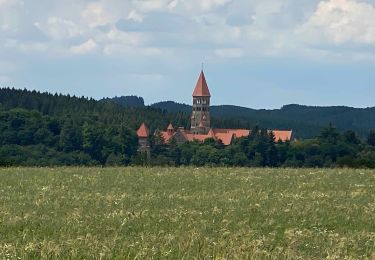
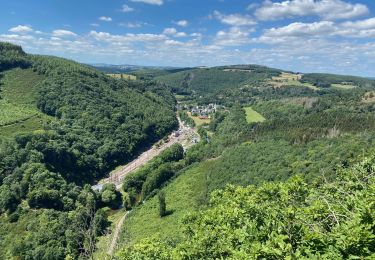
Tour Wandern von 19,2 km verfügbar auf Unbekannt, Kanton Diekirch, Burscheid. Diese Tour wird von dauzata vorgeschlagen.
Beschreibung
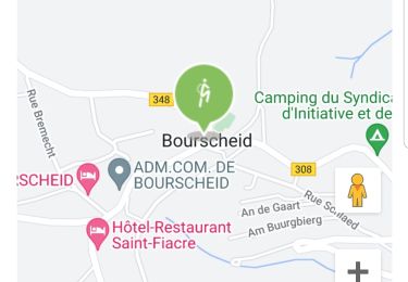
Départ: Moulin de Bourscheid.
Arrivée: Hoscheid, route principale (Haaptstross)
Possibilité de transfert vers Ettelbrück via bus 137 ou 170, arrêt "Hoscheid, Kreizgaass" ou "Hoscheid, Braaken" sur la rue principale.
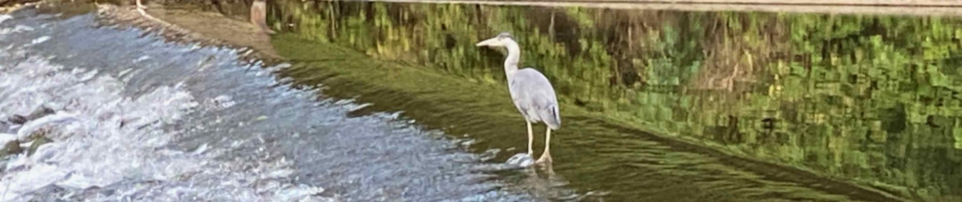
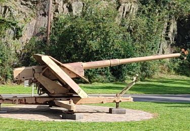
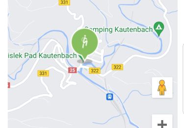
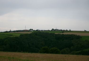
Ort
Land:
Luxembourg
Region :
Unbekannt
Abteilung/Provinz :
Kanton Diekirch
Kommune :
Burscheid
Standort:
Unknown
Gehen Sie:(Dec)
Gehen Sie:(UTM)
290767 ; 5533049 (32U) N.
Kommentare
Touren in der Umgebung
![Tour Wandern Burscheid - Autopedestres : Welscheid 1 - Photo](https://media.geolcdn.com/t/375/260/ext.jpg?maxdim=2&url=https%3A%2F%2Fstatic1.geolcdn.com%2Fsiteimages%2Fupload%2Ffiles%2F1553511878bg_sport_marche.png)
![Wandern Wandern](https://static1.geolcdn.com/sitytour/trail-icons/101.png)
Autopedestres : Welscheid 1
Wandern
Sehr leicht
(1)
Burscheid,
Unbekannt,
Kanton Diekirch,
Luxembourg
![](/images/other/stat-length.png)
6,8 km | 9,8 km-effort
Unbekannt
![](https://static1.geolcdn.com/siteimages/upload/files/16400158638029165_repeat_loop_refresh_sync_direction_icon.png)
Ja
![Tour Wandern Burscheid - Autopedestres : Bourscheid - Photo](https://media.geolcdn.com/t/375/260/ext.jpg?maxdim=2&url=https%3A%2F%2Fstatic1.geolcdn.com%2Fsiteimages%2Fupload%2Ffiles%2F1553511878bg_sport_marche.png)
![Wandern Wandern](https://static1.geolcdn.com/sitytour/trail-icons/101.png)
Autopedestres : Bourscheid
Wandern
Sehr leicht
(2)
Burscheid,
Unbekannt,
Kanton Diekirch,
Luxembourg
![](/images/other/stat-length.png)
10,5 km | 15,3 km-effort
Unbekannt
![](https://static1.geolcdn.com/siteimages/upload/files/16400158638029165_repeat_loop_refresh_sync_direction_icon.png)
Ja
![Tour Wandern Kiischpelt - eislek trail de Kautenbach à Troisvierges - Photo](https://media.geolcdn.com/t/375/260/fa22f2d8-d5f7-4d5a-bd3c-5a3522af9299.jpg&format=jpg&maxdim=2)
![Wandern Wandern](https://static1.geolcdn.com/sitytour/trail-icons/101.png)
eislek trail de Kautenbach à Troisvierges
Wandern
Schwierig
Kiischpelt,
Unbekannt,
Kanton Wiltz,
Luxembourg
![](/images/other/stat-length.png)
42 km | 61 km-effort
12h 30min
![](https://static1.geolcdn.com/siteimages/upload/files/16400158638029165_repeat_loop_refresh_sync_direction_icon.png)
Nein
![Tour Wandern Kiischpelt - 2022-09-22_13h29m24_t62885235_eislek pad kautenbach (1) - Photo](https://media.geolcdn.com/t/375/260/0c0135b5-3869-4e5e-9de6-2c826fdc4a40.jpg&format=jpg&maxdim=2)
![Wandern Wandern](https://static1.geolcdn.com/sitytour/trail-icons/101.png)
2022-09-22_13h29m24_t62885235_eislek pad kautenbach (1)
Wandern
Medium
Kiischpelt,
Unbekannt,
Kanton Wiltz,
Luxembourg
![](/images/other/stat-length.png)
14,4 km | 22 km-effort
4h 58min
![](https://static1.geolcdn.com/siteimages/upload/files/16400158638029165_repeat_loop_refresh_sync_direction_icon.png)
Ja
![Tour Wandern Burscheid - 2022-09-22_13h10m58_t62880921_eislek pad bourscheid - Photo](https://media.geolcdn.com/t/375/260/22286de4-94ea-4b92-acbb-a4fc138a2ba8.jpg&format=jpg&maxdim=2)
![Wandern Wandern](https://static1.geolcdn.com/sitytour/trail-icons/101.png)
2022-09-22_13h10m58_t62880921_eislek pad bourscheid
Wandern
Medium
Burscheid,
Unbekannt,
Kanton Diekirch,
Luxembourg
![](/images/other/stat-length.png)
14,8 km | 23 km-effort
5h 10min
![](https://static1.geolcdn.com/siteimages/upload/files/16400158638029165_repeat_loop_refresh_sync_direction_icon.png)
Ja
![Tour Wandern Kiischpelt - Escapardenne Eisleck Trail: Kautenbach - Clervaux - Photo](https://media.geolcdn.com/t/375/260/86b391f6-6800-4c48-b33b-03a021b1a218.jpeg&format=jpg&maxdim=2)
![Wandern Wandern](https://static1.geolcdn.com/sitytour/trail-icons/101.png)
Escapardenne Eisleck Trail: Kautenbach - Clervaux
Wandern
Schwierig
Kiischpelt,
Unbekannt,
Kanton Wiltz,
Luxembourg
![](/images/other/stat-length.png)
25 km | 38 km-effort
6h 21min
![](https://static1.geolcdn.com/siteimages/upload/files/16400158638029165_repeat_loop_refresh_sync_direction_icon.png)
Nein
![Tour Wandern Park Hosingen - Escapardenne Lee Trail: Hoscheid - Kautenbach - Photo](https://media.geolcdn.com/t/375/260/8bf23a72-7eca-4436-91e5-2141dda4e2a9.jpeg&format=jpg&maxdim=2)
![Wandern Wandern](https://static1.geolcdn.com/sitytour/trail-icons/101.png)
Escapardenne Lee Trail: Hoscheid - Kautenbach
Wandern
Medium
Park Hosingen,
Unbekannt,
Kanton Clerf,
Luxembourg
![](/images/other/stat-length.png)
15,5 km | 23 km-effort
4h 25min
![](https://static1.geolcdn.com/siteimages/upload/files/16400158638029165_repeat_loop_refresh_sync_direction_icon.png)
Nein
![Tour Zu Fuß Burscheid - Autopedestre Schlindermanderscheid - Photo](https://media.geolcdn.com/t/375/260/b96de446-0e31-4144-a1e8-49f30dc2459e.jpeg&format=jpg&maxdim=2)
![Zu Fuß Zu Fuß](https://static1.geolcdn.com/sitytour/trail-icons/100.png)
Autopedestre Schlindermanderscheid
Zu Fuß
Einfach
Burscheid,
Unbekannt,
Kanton Diekirch,
Luxembourg
![](/images/other/stat-length.png)
7,5 km | 12 km-effort
2h 43min
![](https://static1.geolcdn.com/siteimages/upload/files/16400158638029165_repeat_loop_refresh_sync_direction_icon.png)
Ja
![Tour Zu Fuß Tandel - Autopedestre Brandenbourg - Photo](https://media.geolcdn.com/t/375/260/f773c6ce-1e62-48fa-9c88-bf2c6a499187.jpeg&format=jpg&maxdim=2)
![Zu Fuß Zu Fuß](https://static1.geolcdn.com/sitytour/trail-icons/100.png)
Autopedestre Brandenbourg
Zu Fuß
Einfach
Tandel,
Unbekannt,
Kanton Vianden,
Luxembourg
![](/images/other/stat-length.png)
6,4 km | 9 km-effort
2h 2min
![](https://static1.geolcdn.com/siteimages/upload/files/16400158638029165_repeat_loop_refresh_sync_direction_icon.png)
Ja