![](/images/other/stat-length.png)
![Tour Wandern Le Boulou - Pic Estelle (377m) - Le Boulou - Pyrénées orientales (66) - Photo](https://media.geolcdn.com/t/1900/400/e232faca-0036-4399-b7af-e7d27b87588b.jpg&format=pjpeg&maxdim=2)
Pic Estelle (377m) - Le Boulou - Pyrénées orientales (66)
toutankhcarton
Benutzer GUIDE
![Länge](/images/other/stat-length.png)
Länge
10,9 km
![Maximale Höhe](https://static1.geolcdn.com/siteimages/upload/files/1508320355ic_sort_altitude_max_24dp.png)
Maximale Höhe
369 m
![Positive Höhendifferenz](https://static1.geolcdn.com/siteimages/upload/files/1508320355ic_sort_den_pos_24dp.png)
Positive Höhendifferenz
380 m
![Km-Effort](/images/other/stat-length.png)
Km-Effort
15,9 km
![Min. Höhe](https://static1.geolcdn.com/siteimages/upload/files/1508320355ic_sort_altitude_min_24dp.png)
Min. Höhe
71 m
![Negative Höhendifferenz](https://static1.geolcdn.com/siteimages/upload/files/1508320355ic_sort_den_neg_24dp.png)
Negative Höhendifferenz
381 m
![Boucle](https://static1.geolcdn.com/siteimages/upload/files/16400158638029165_repeat_loop_refresh_sync_direction_icon.png)
Boucle
Ja
Erstellungsdatum :
2022-07-07 05:48:44.611
Letzte Änderung :
2022-07-07 09:52:05.632
![Wandern](https://static1.geolcdn.com/sitytour/trail-icons/101.png)
2h19
Schwierigkeit : Sehr leicht
![Scannen Sie diesen QR-Code, um die Tour in der SityTrail-Anwendung zu öffnen](https://capi.geolives.com/qq0zvz2zws4bq2lad0pu/sitytour/trails/3307407/qr.png?size=200)
Kostenlosegpshiking-Anwendung
Über SityTrail
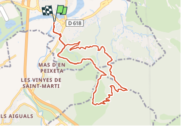
Tour Wandern von 10,9 km verfügbar auf Okzitanien, Ostpyrenäen, Le Boulou. Diese Tour wird von toutankhcarton vorgeschlagen.
Beschreibung
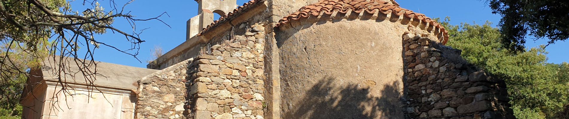
Montée au Pic Estelle depuis le casino Joa. Petit raidillon au départ puis passage par la chapelle romane St Pierre de Laner (XIIe).
Regagner la piste en contre bas de la chapelle pour revenir au Boulou.
Ort
Land:
France
Region :
Okzitanien
Abteilung/Provinz :
Ostpyrenäen
Kommune :
Le Boulou
Standort:
Unknown
Gehen Sie:(Dec)
Gehen Sie:(UTM)
485891 ; 4707256 (31T) N.
Kommentare
Touren in der Umgebung
![Tour Wandern Le Boulou - rando de la bataille du Boulou - Photo](https://media.geolcdn.com/t/375/260/aa2b3d38-bac5-4589-a4ac-8bd34f744e79.jpg&format=jpg&maxdim=2)
![Wandern Wandern](https://static1.geolcdn.com/sitytour/trail-icons/101.png)
rando de la bataille du Boulou
Wandern
Sehr schwierig
(1)
Le Boulou,
Okzitanien,
Ostpyrenäen,
France
![](/images/other/stat-length.png)
8,4 km | 10,5 km-effort
3h 27min
![](https://static1.geolcdn.com/siteimages/upload/files/16400158638029165_repeat_loop_refresh_sync_direction_icon.png)
Ja
![Tour Wandern Les Cluses - LES CLUSES 66 - Photo](https://media.geolcdn.com/t/375/260/ext.jpg?maxdim=2&url=https%3A%2F%2Fstatic1.geolcdn.com%2Fsiteimages%2Fupload%2Ffiles%2F1553511878bg_sport_marche.png)
![Wandern Wandern](https://static1.geolcdn.com/sitytour/trail-icons/101.png)
LES CLUSES 66
Wandern
Einfach
(10)
Les Cluses,
Okzitanien,
Ostpyrenäen,
France
![](/images/other/stat-length.png)
9,4 km | 12,8 km-effort
1h 50min
![](https://static1.geolcdn.com/siteimages/upload/files/16400158638029165_repeat_loop_refresh_sync_direction_icon.png)
Ja
![Tour Wandern Saint-Jean-Pla-de-Corts - 66 ST-JEAN-PLA-DE-CORTS, promenade autour du Tech, jusqu'au BOULOU - Photo](https://media.geolcdn.com/t/375/260/ext.jpg?maxdim=2&url=https%3A%2F%2Fservices.sitytrail.com%2FGeolivesWS%2FDownloadMedia.ashx%3FTrailID%3D519982%26Media%3D20160131140429.jpg)
![Wandern Wandern](https://static1.geolcdn.com/sitytour/trail-icons/101.png)
66 ST-JEAN-PLA-DE-CORTS, promenade autour du Tech, jusqu'au BOULOU
Wandern
Einfach
(1)
Saint-Jean-Pla-de-Corts,
Okzitanien,
Ostpyrenäen,
France
![](/images/other/stat-length.png)
7,9 km | 8,8 km-effort
1h 18min
![](https://static1.geolcdn.com/siteimages/upload/files/16400158638029165_repeat_loop_refresh_sync_direction_icon.png)
Ja
![Tour Wandern Montesquieu-des-Albères - MONTESQUIEU-DES-ALBERES 66 - Les Agouillous - les chemins de l'eau dans les Albères - Photo](https://media.geolcdn.com/t/375/260/ext.jpg?maxdim=2&url=https%3A%2F%2Fservices.sitytrail.com%2FGeolivesWS%2FDownloadMedia.ashx%3FTrailID%3D451257%26Media%3D20150728182708.jpg)
![Wandern Wandern](https://static1.geolcdn.com/sitytour/trail-icons/101.png)
MONTESQUIEU-DES-ALBERES 66 - Les Agouillous - les chemins de l'eau dans les A...
Wandern
Medium
(1)
Montesquieu-des-Albères,
Okzitanien,
Ostpyrenäen,
France
![](/images/other/stat-length.png)
12,7 km | 13,9 km-effort
2h 16min
![](https://static1.geolcdn.com/siteimages/upload/files/16400158638029165_repeat_loop_refresh_sync_direction_icon.png)
Ja
![Tour Wandern Le Boulou - LES THERMES DU BOULOU - 66 - Albera viva - PUIG de l'Estella - Photo](https://media.geolcdn.com/t/375/260/ext.jpg?maxdim=2&url=https%3A%2F%2Fservices.sitytrail.com%2FGeolivesWS%2FDownloadMedia.ashx%3FTrailID%3D443397%26Media%3D20150709200943.jpg)
![Wandern Wandern](https://static1.geolcdn.com/sitytour/trail-icons/101.png)
LES THERMES DU BOULOU - 66 - Albera viva - PUIG de l'Estella
Wandern
Medium
(2)
Le Boulou,
Okzitanien,
Ostpyrenäen,
France
![](/images/other/stat-length.png)
7,3 km | 11,4 km-effort
1h 32min
![](https://static1.geolcdn.com/siteimages/upload/files/16400158638029165_repeat_loop_refresh_sync_direction_icon.png)
Ja
![Tour Wandern Le Boulou - Bataille du Boulou (1793 - 1794) - Photo](https://media.geolcdn.com/t/375/260/e8fd6dc5-027d-40cc-9239-020c7f056093.jpg&format=jpg&maxdim=2)
![Wandern Wandern](https://static1.geolcdn.com/sitytour/trail-icons/101.png)
Bataille du Boulou (1793 - 1794)
Wandern
Sehr leicht
Le Boulou,
Okzitanien,
Ostpyrenäen,
France
![](/images/other/stat-length.png)
10,4 km | 13,2 km-effort
1h 57min
![](https://static1.geolcdn.com/siteimages/upload/files/16400158638029165_repeat_loop_refresh_sync_direction_icon.png)
Ja
![Tour Hybrid-Bike Le Boulou - Autour du Boulou (66) - Photo](https://media.geolcdn.com/t/375/260/1d105df1-7b05-435b-be16-23a1a2dd8321.jpg&format=jpg&maxdim=2)
![Hybrid-Bike Hybrid-Bike](https://static1.geolcdn.com/sitytour/trail-icons/203.png)
Autour du Boulou (66)
Hybrid-Bike
Einfach
Le Boulou,
Okzitanien,
Ostpyrenäen,
France
![](/images/other/stat-length.png)
17 km | 19,5 km-effort
1h 54min
![](https://static1.geolcdn.com/siteimages/upload/files/16400158638029165_repeat_loop_refresh_sync_direction_icon.png)
Nein
![Tour Wandern Montesquieu-des-Albères - montesquieu . puig sant cristau . prieuré Santa maria del villard . montesquieu - Photo](https://media.geolcdn.com/t/375/260/ext.jpg?maxdim=2&url=https%3A%2F%2Fservices.sitytrail.com%2FGeolivesWS%2FDownloadMedia.ashx%3FTrailID%3D940648%26Media%3Dfix__20180410173102.jpg)
![Wandern Wandern](https://static1.geolcdn.com/sitytour/trail-icons/101.png)
montesquieu . puig sant cristau . prieuré Santa maria del villard . montesquieu
Wandern
Schwierig
Montesquieu-des-Albères,
Okzitanien,
Ostpyrenäen,
France
![](/images/other/stat-length.png)
15,7 km | 31 km-effort
7h 51min
![](https://static1.geolcdn.com/siteimages/upload/files/16400158638029165_repeat_loop_refresh_sync_direction_icon.png)
Ja
![Tour Wandern Les Cluses - LES CLUSES 66 - LE PERTHUS - - Photo](https://media.geolcdn.com/t/375/260/ext.jpg?maxdim=2&url=https%3A%2F%2Fstatic1.geolcdn.com%2Fsiteimages%2Fupload%2Ffiles%2F1553511878bg_sport_marche.png)
![Wandern Wandern](https://static1.geolcdn.com/sitytour/trail-icons/101.png)
LES CLUSES 66 - LE PERTHUS -
Wandern
Medium
(2)
Les Cluses,
Okzitanien,
Ostpyrenäen,
France
![](/images/other/stat-length.png)
14,4 km | 20 km-effort
2h 57min
![](https://static1.geolcdn.com/siteimages/upload/files/16400158638029165_repeat_loop_refresh_sync_direction_icon.png)
Ja