![](/images/other/stat-length.png)
![Tour Mountainbike Cosne-d'Allier - Cosne d'Allier Forêt domaniale de Dreuille - Photo](https://media.geolcdn.com/t/1900/400/ext.pjpeg?maxdim=2&url=https%3A%2F%2Fstatic1.geolcdn.com%2Fsiteimages%2Fupload%2Ffiles%2F1524743154velo.jpg)
Cosne d'Allier Forêt domaniale de Dreuille
CamilleDusart
Benutzer
![Länge](/images/other/stat-length.png)
Länge
44 km
![Maximale Höhe](https://static1.geolcdn.com/siteimages/upload/files/1508320355ic_sort_altitude_max_24dp.png)
Maximale Höhe
324 m
![Positive Höhendifferenz](https://static1.geolcdn.com/siteimages/upload/files/1508320355ic_sort_den_pos_24dp.png)
Positive Höhendifferenz
422 m
![Km-Effort](/images/other/stat-length.png)
Km-Effort
49 km
![Min. Höhe](https://static1.geolcdn.com/siteimages/upload/files/1508320355ic_sort_altitude_min_24dp.png)
Min. Höhe
223 m
![Negative Höhendifferenz](https://static1.geolcdn.com/siteimages/upload/files/1508320355ic_sort_den_neg_24dp.png)
Negative Höhendifferenz
421 m
![Boucle](https://static1.geolcdn.com/siteimages/upload/files/16400158638029165_repeat_loop_refresh_sync_direction_icon.png)
Boucle
Ja
Erstellungsdatum :
2022-07-06 09:34:08.611
Letzte Änderung :
2022-07-06 09:52:00.563
![Mountainbike](https://static1.geolcdn.com/sitytour/trail-icons/202.png)
3h29
Schwierigkeit : Medium
![Scannen Sie diesen QR-Code, um die Tour in der SityTrail-Anwendung zu öffnen](https://capi.geolives.com/qq0zvz2zws4bq2lad0pu/sitytour/trails/3306276/qr.png?size=200)
Kostenlosegpshiking-Anwendung
Über SityTrail
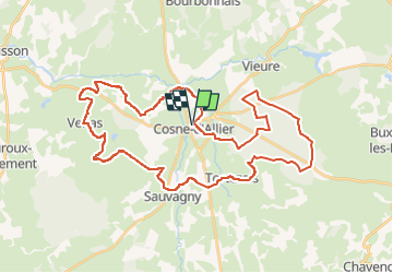
Tour Mountainbike von 44 km verfügbar auf Auvergne-Rhone-Alpen, Allier, Cosne-d'Allier. Diese Tour wird von CamilleDusart vorgeschlagen.
Beschreibung
bocage bourbonnais et forêt domaniale
chemin de lisière entre la Madeleine et la croix de Ferrières à confirmer
Ort
Land:
France
Region :
Auvergne-Rhone-Alpen
Abteilung/Provinz :
Allier
Kommune :
Cosne-d'Allier
Standort:
Unknown
Gehen Sie:(Dec)
Gehen Sie:(UTM)
487115 ; 5146933 (31T) N.
Kommentare
Touren in der Umgebung
![Tour Mountainbike Cosne-d'Allier - COSNE D'ALLIER Nord Nov 2024 - Photo](https://media.geolcdn.com/t/375/260/ext.jpg?maxdim=2&url=https%3A%2F%2Fstatic1.geolcdn.com%2Fsiteimages%2Fupload%2Ffiles%2F1524743154velo.jpg)
![Mountainbike Mountainbike](https://static1.geolcdn.com/sitytour/trail-icons/202.png)
COSNE D'ALLIER Nord Nov 2024
Mountainbike
Sehr schwierig
Cosne-d'Allier,
Auvergne-Rhone-Alpen,
Allier,
France
![](/images/other/stat-length.png)
47 km | 56 km-effort
3h 31min
![](https://static1.geolcdn.com/siteimages/upload/files/16400158638029165_repeat_loop_refresh_sync_direction_icon.png)
Ja
![Tour Rennrad Vieure - GRAVEL - Vieure/Tortezais/Neuville/Venas/COSNE/Mqrmenailles - Photo](https://media.geolcdn.com/t/375/260/ext.jpg?maxdim=2&url=https%3A%2F%2Fstatic1.geolcdn.com%2Fsiteimages%2Fupload%2Ffiles%2F1524743154velo.jpg)
![Rennrad Rennrad](https://static1.geolcdn.com/sitytour/trail-icons/201.png)
GRAVEL - Vieure/Tortezais/Neuville/Venas/COSNE/Mqrmenailles
Rennrad
Sehr leicht
Vieure,
Auvergne-Rhone-Alpen,
Allier,
France
![](/images/other/stat-length.png)
37 km | 42 km-effort
2h 30min
![](https://static1.geolcdn.com/siteimages/upload/files/16400158638029165_repeat_loop_refresh_sync_direction_icon.png)
Ja
![Tour Wandern Cosne-d'Allier - Les boules - Photo](https://media.geolcdn.com/t/375/260/ext.jpg?maxdim=2&url=https%3A%2F%2Fstatic1.geolcdn.com%2Fsiteimages%2Fupload%2Ffiles%2F1553511878bg_sport_marche.png)
![Wandern Wandern](https://static1.geolcdn.com/sitytour/trail-icons/101.png)
Les boules
Wandern
Cosne-d'Allier,
Auvergne-Rhone-Alpen,
Allier,
France
![](/images/other/stat-length.png)
6,1 km | 7,1 km-effort
1h 17min
![](https://static1.geolcdn.com/siteimages/upload/files/16400158638029165_repeat_loop_refresh_sync_direction_icon.png)
Nein
![Tour Mountainbike Tortezais - tortezais - Photo](https://media.geolcdn.com/t/375/260/ext.jpg?maxdim=2&url=https%3A%2F%2Fstatic1.geolcdn.com%2Fsiteimages%2Fupload%2Ffiles%2F1524743154velo.jpg)
![Mountainbike Mountainbike](https://static1.geolcdn.com/sitytour/trail-icons/202.png)
tortezais
Mountainbike
Medium
Tortezais,
Auvergne-Rhone-Alpen,
Allier,
France
![](/images/other/stat-length.png)
38 km | 44 km-effort
3h 54min
![](https://static1.geolcdn.com/siteimages/upload/files/16400158638029165_repeat_loop_refresh_sync_direction_icon.png)
Ja
![Tour Mountainbike Cosne-d'Allier - AUTOUR DE COSNE - Photo](https://media.geolcdn.com/t/375/260/ext.jpg?maxdim=2&url=https%3A%2F%2Fstatic1.geolcdn.com%2Fsiteimages%2Fupload%2Ffiles%2F1524743154velo.jpg)
![Mountainbike Mountainbike](https://static1.geolcdn.com/sitytour/trail-icons/202.png)
AUTOUR DE COSNE
Mountainbike
Sehr schwierig
Cosne-d'Allier,
Auvergne-Rhone-Alpen,
Allier,
France
![](/images/other/stat-length.png)
50 km | 59 km-effort
4h 3min
![](https://static1.geolcdn.com/siteimages/upload/files/16400158638029165_repeat_loop_refresh_sync_direction_icon.png)
Ja
![Tour Mountainbike Cosne-d'Allier - cosne Nord 2024 - Photo](https://media.geolcdn.com/t/375/260/ext.jpg?maxdim=2&url=https%3A%2F%2Fstatic1.geolcdn.com%2Fsiteimages%2Fupload%2Ffiles%2F1524743154velo.jpg)
![Mountainbike Mountainbike](https://static1.geolcdn.com/sitytour/trail-icons/202.png)
cosne Nord 2024
Mountainbike
Sehr schwierig
Cosne-d'Allier,
Auvergne-Rhone-Alpen,
Allier,
France
![](/images/other/stat-length.png)
47 km | 56 km-effort
3h 29min
![](https://static1.geolcdn.com/siteimages/upload/files/16400158638029165_repeat_loop_refresh_sync_direction_icon.png)
Nein
![Tour Wandern Vieure - parcelles 8 + 9 - Photo](https://media.geolcdn.com/t/375/260/ext.jpg?maxdim=2&url=https%3A%2F%2Fstatic1.geolcdn.com%2Fsiteimages%2Fupload%2Ffiles%2F1553511878bg_sport_marche.png)
![Wandern Wandern](https://static1.geolcdn.com/sitytour/trail-icons/101.png)
parcelles 8 + 9
Wandern
Medium
Vieure,
Auvergne-Rhone-Alpen,
Allier,
France
![](/images/other/stat-length.png)
7,1 km | 8,3 km-effort
2h 39min
![](https://static1.geolcdn.com/siteimages/upload/files/16400158638029165_repeat_loop_refresh_sync_direction_icon.png)
Ja
![Tour Jagen Vieure - Dreuille - Photo](https://media.geolcdn.com/t/375/260/ext.jpg?maxdim=2&url=https%3A%2F%2Fstatic1.geolcdn.com%2Fsiteimages%2Fupload%2Ffiles%2F1545311037marcheuse_200dpi.jpg)
![Jagen Jagen](https://static1.geolcdn.com/sitytour/trail-icons/905.png)
Dreuille
Jagen
Sehr leicht
Vieure,
Auvergne-Rhone-Alpen,
Allier,
France
![](/images/other/stat-length.png)
3,7 km | 4 km-effort
1h 54min
![](https://static1.geolcdn.com/siteimages/upload/files/16400158638029165_repeat_loop_refresh_sync_direction_icon.png)
Ja