![](/images/other/stat-length.png)
![Tour Wandern Etxalar - Rando Ibanteli - Photo](https://media.geolcdn.com/t/1900/400/ext.pjpeg?maxdim=2&url=https%3A%2F%2Fstatic1.geolcdn.com%2Fsiteimages%2Fupload%2Ffiles%2F1553511878bg_sport_marche.png)
Rando Ibanteli
Fab-Oz
Benutzer
![Länge](/images/other/stat-length.png)
Länge
7,7 km
![Maximale Höhe](https://static1.geolcdn.com/siteimages/upload/files/1508320355ic_sort_altitude_max_24dp.png)
Maximale Höhe
681 m
![Positive Höhendifferenz](https://static1.geolcdn.com/siteimages/upload/files/1508320355ic_sort_den_pos_24dp.png)
Positive Höhendifferenz
487 m
![Km-Effort](/images/other/stat-length.png)
Km-Effort
14,2 km
![Min. Höhe](https://static1.geolcdn.com/siteimages/upload/files/1508320355ic_sort_altitude_min_24dp.png)
Min. Höhe
220 m
![Negative Höhendifferenz](https://static1.geolcdn.com/siteimages/upload/files/1508320355ic_sort_den_neg_24dp.png)
Negative Höhendifferenz
489 m
![Boucle](https://static1.geolcdn.com/siteimages/upload/files/16400158638029165_repeat_loop_refresh_sync_direction_icon.png)
Boucle
Ja
Erstellungsdatum :
2022-07-05 14:00:42.898
Letzte Änderung :
2022-07-05 16:57:39.284
![Wandern](https://static1.geolcdn.com/sitytour/trail-icons/101.png)
2h55
Schwierigkeit : Schwierig
![Scannen Sie diesen QR-Code, um die Tour in der SityTrail-Anwendung zu öffnen](https://capi.geolives.com/qq0zvz2zws4bq2lad0pu/sitytour/trails/3305666/qr.png?size=200)
Kostenlosegpshiking-Anwendung
Über SityTrail
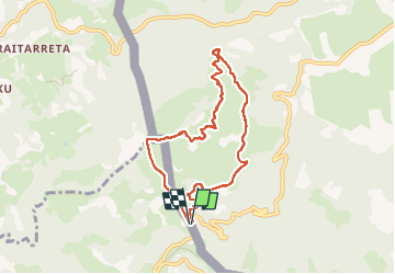
Tour Wandern von 7,7 km verfügbar auf Navarra, Unbekannt, Etxalar. Diese Tour wird von Fab-Oz vorgeschlagen.
Beschreibung
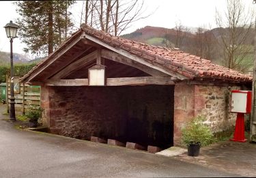
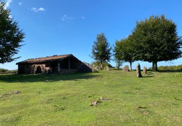
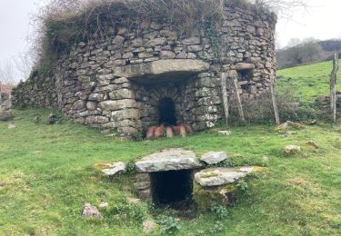
Au départ du col de Lizzareta
montée jusqu'au sommet d'Ibanteli
ATTENTION ne pas suivre ma trace pour le retour car hors sentier, avec descente à travers les fougères, ronces, et même franchissement de 2 barbelés lol pour retrouver un chemin. normal
Ort
Land:
Spain
Region :
Navarra
Abteilung/Provinz :
Unbekannt
Kommune :
Etxalar
Standort:
Unknown
Gehen Sie:(Dec)
Gehen Sie:(UTM)
612065 ; 4790718 (30T) N.
Kommentare
Touren in der Umgebung
![Tour Zu Fuß Etxalar - SL-NA 5 Argarata - Santa Krutz - Photo](https://media.geolcdn.com/t/375/260/94bbb8c0-a5b3-4c45-bc43-34bd6d9df6cd.jpeg&format=jpg&maxdim=2)
![Zu Fuß Zu Fuß](https://static1.geolcdn.com/sitytour/trail-icons/100.png)
SL-NA 5 Argarata - Santa Krutz
Zu Fuß
Einfach
Etxalar,
Navarra,
Unbekannt,
Spain
![](/images/other/stat-length.png)
4,5 km | 5,7 km-effort
1h 17min
![](https://static1.geolcdn.com/siteimages/upload/files/16400158638029165_repeat_loop_refresh_sync_direction_icon.png)
Ja
![Tour Wandern Sare - La rhune par la face EST - Photo](https://media.geolcdn.com/t/375/260/ext.jpg?maxdim=2&url=https%3A%2F%2Fstatic1.geolcdn.com%2Fsiteimages%2Fupload%2Ffiles%2F1553511878bg_sport_marche.png)
![Wandern Wandern](https://static1.geolcdn.com/sitytour/trail-icons/101.png)
La rhune par la face EST
Wandern
Medium
(1)
Sare,
Neu-Aquitanien,
Pyrenäen-Atlantik,
France
![](/images/other/stat-length.png)
13,8 km | 26 km-effort
5h 10min
![](https://static1.geolcdn.com/siteimages/upload/files/16400158638029165_repeat_loop_refresh_sync_direction_icon.png)
Ja
![Tour Wandern Sare - sare les palombieres - Photo](https://media.geolcdn.com/t/375/260/ext.jpg?maxdim=2&url=https%3A%2F%2Fservices.sitytrail.com%2FGeolivesWS%2FDownloadMedia.ashx%3FTrailID%3D226934%26Media%3D20131002143837.jpg)
![Wandern Wandern](https://static1.geolcdn.com/sitytour/trail-icons/101.png)
sare les palombieres
Wandern
Einfach
Sare,
Neu-Aquitanien,
Pyrenäen-Atlantik,
France
![](/images/other/stat-length.png)
15,8 km | 24 km-effort
4h 44min
![](https://static1.geolcdn.com/siteimages/upload/files/16400158638029165_repeat_loop_refresh_sync_direction_icon.png)
Ja
![Tour Wandern Sare - atxuria zugaramurdi - Photo](https://media.geolcdn.com/t/375/260/ext.jpg?maxdim=2&url=https%3A%2F%2Fstatic1.geolcdn.com%2Fsiteimages%2Fupload%2Ffiles%2F1553511878bg_sport_marche.png)
![Wandern Wandern](https://static1.geolcdn.com/sitytour/trail-icons/101.png)
atxuria zugaramurdi
Wandern
Sehr leicht
(3)
Sare,
Neu-Aquitanien,
Pyrenäen-Atlantik,
France
![](/images/other/stat-length.png)
10,3 km | 18,7 km-effort
3h 50min
![](https://static1.geolcdn.com/siteimages/upload/files/16400158638029165_repeat_loop_refresh_sync_direction_icon.png)
Ja
![Tour Wandern Sare - Lizarieta descente par palombieres - Photo](https://media.geolcdn.com/t/375/260/9d6ad3d3-a9ac-4160-b5e2-482251e1a583.jpg&format=jpg&maxdim=2)
![Wandern Wandern](https://static1.geolcdn.com/sitytour/trail-icons/101.png)
Lizarieta descente par palombieres
Wandern
Sehr leicht
Sare,
Neu-Aquitanien,
Pyrenäen-Atlantik,
France
![](/images/other/stat-length.png)
8,9 km | 11,9 km-effort
2h 49min
![](https://static1.geolcdn.com/siteimages/upload/files/16400158638029165_repeat_loop_refresh_sync_direction_icon.png)
Nein
![Tour Wandern Sare - col de lizarrieta et col des 3 bornes - Photo](https://media.geolcdn.com/t/375/260/4a8eca64-9908-469c-ac1f-6551c3878583.jpg&format=jpg&maxdim=2)
![Wandern Wandern](https://static1.geolcdn.com/sitytour/trail-icons/101.png)
col de lizarrieta et col des 3 bornes
Wandern
Schwierig
Sare,
Neu-Aquitanien,
Pyrenäen-Atlantik,
France
![](/images/other/stat-length.png)
13 km | 18,5 km-effort
3h 45min
![](https://static1.geolcdn.com/siteimages/upload/files/16400158638029165_repeat_loop_refresh_sync_direction_icon.png)
Ja
![Tour Wandern Sare - Lizarrieta, Zentinel, col des 3 bornes, 2024 03 04. - Photo](https://media.geolcdn.com/t/375/260/8ac35c6d-8e84-4286-9748-27c916c27140.jpg&format=jpg&maxdim=2)
![Wandern Wandern](https://static1.geolcdn.com/sitytour/trail-icons/101.png)
Lizarrieta, Zentinel, col des 3 bornes, 2024 03 04.
Wandern
Schwierig
Sare,
Neu-Aquitanien,
Pyrenäen-Atlantik,
France
![](/images/other/stat-length.png)
12,4 km | 17,8 km-effort
4h 3min
![](https://static1.geolcdn.com/siteimages/upload/files/16400158638029165_repeat_loop_refresh_sync_direction_icon.png)
Ja
![Tour Wandern Sare - Palombieres ibantelli - Photo](https://media.geolcdn.com/t/375/260/76acc27f-1655-4a4b-967e-18a83da8848a.jpg&format=jpg&maxdim=2)
![Wandern Wandern](https://static1.geolcdn.com/sitytour/trail-icons/101.png)
Palombieres ibantelli
Wandern
Einfach
Sare,
Neu-Aquitanien,
Pyrenäen-Atlantik,
France
![](/images/other/stat-length.png)
14,8 km | 0 m-effort
5h 6min
![](https://static1.geolcdn.com/siteimages/upload/files/16400158638029165_repeat_loop_refresh_sync_direction_icon.png)
Ja
![Tour Wandern Sare - Atxuria tour par zugaramurdi - Photo](https://media.geolcdn.com/t/375/260/3066bfa2-9b4e-4a27-8cc8-e3c2b1a385fe.jpg&format=jpg&maxdim=2)
![Wandern Wandern](https://static1.geolcdn.com/sitytour/trail-icons/101.png)
Atxuria tour par zugaramurdi
Wandern
Einfach
Sare,
Neu-Aquitanien,
Pyrenäen-Atlantik,
France
![](/images/other/stat-length.png)
14,7 km | 24 km-effort
4h 43min
![](https://static1.geolcdn.com/siteimages/upload/files/16400158638029165_repeat_loop_refresh_sync_direction_icon.png)
Ja