![](/images/other/stat-length.png)
![Tour Nordic Walking Bourg-Saint-Maurice - Du cabriolet au Bois de l'ours - Photo](https://media.geolcdn.com/t/1900/400/ext.pjpeg?maxdim=2&url=https%3A%2F%2Fstatic1.geolcdn.com%2Fsiteimages%2Fupload%2Ffiles%2F1545311037marcheuse_200dpi.jpg)
Du cabriolet au Bois de l'ours
gilsep
Benutzer
![Länge](/images/other/stat-length.png)
Länge
4,6 km
![Maximale Höhe](https://static1.geolcdn.com/siteimages/upload/files/1508320355ic_sort_altitude_max_24dp.png)
Maximale Höhe
2290 m
![Positive Höhendifferenz](https://static1.geolcdn.com/siteimages/upload/files/1508320355ic_sort_den_pos_24dp.png)
Positive Höhendifferenz
190 m
![Km-Effort](/images/other/stat-length.png)
Km-Effort
7,4 km
![Min. Höhe](https://static1.geolcdn.com/siteimages/upload/files/1508320355ic_sort_altitude_min_24dp.png)
Min. Höhe
2044 m
![Negative Höhendifferenz](https://static1.geolcdn.com/siteimages/upload/files/1508320355ic_sort_den_neg_24dp.png)
Negative Höhendifferenz
270 m
![Boucle](https://static1.geolcdn.com/siteimages/upload/files/16400158638029165_repeat_loop_refresh_sync_direction_icon.png)
Boucle
Nein
Erstellungsdatum :
2014-12-10 00:00:00.0
Letzte Änderung :
2014-12-10 00:00:00.0
![Nordic Walking](https://static1.geolcdn.com/sitytour/trail-icons/102.png)
1h30
Schwierigkeit : Einfach
![Scannen Sie diesen QR-Code, um die Tour in der SityTrail-Anwendung zu öffnen](https://capi.geolives.com/qq0zvz2zws4bq2lad0pu/sitytour/trails/329806/qr.png?size=200)
Kostenlosegpshiking-Anwendung
Über SityTrail
Tour Nordic Walking von 4,6 km verfügbar auf Auvergne-Rhone-Alpen, Savoyen, Bourg-Saint-Maurice. Diese Tour wird von gilsep vorgeschlagen.
Beschreibung
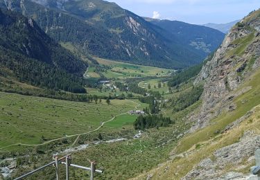
itinéraire de marche nordique variée et agréable. Départ des Arcs 1950, prendre le cabriolet (gratuit).
Ort
Land:
France
Region :
Auvergne-Rhone-Alpen
Abteilung/Provinz :
Savoyen
Kommune :
Bourg-Saint-Maurice
Standort:
Unknown
Gehen Sie:(Dec)
Gehen Sie:(UTM)
330746 ; 5048622 (32T) N.
Kommentare
Touren in der Umgebung
![Tour Skiwanderen Montvalezan - Pointe des couloureuses couloir ouest du passage du Retour - Photo](https://media.geolcdn.com/t/375/260/3e3eb199-e795-49ca-ade2-348294ef2b6d.jpg&format=jpg&maxdim=2)
![Skiwanderen Skiwanderen](https://static1.geolcdn.com/sitytour/trail-icons/503.png)
Pointe des couloureuses couloir ouest du passage du Retour
Skiwanderen
Medium
Montvalezan,
Auvergne-Rhone-Alpen,
Savoyen,
France
![](/images/other/stat-length.png)
12 km | 29 km-effort
5h 5min
![](https://static1.geolcdn.com/siteimages/upload/files/16400158638029165_repeat_loop_refresh_sync_direction_icon.png)
Ja
![Tour Skiwanderen Bourg-Saint-Maurice - col des roches vers le Pourri - Photo](https://media.geolcdn.com/t/375/260/1b6a1c42-133a-4e34-bc5c-807990c98faf.jpg&format=jpg&maxdim=2)
![Skiwanderen Skiwanderen](https://static1.geolcdn.com/sitytour/trail-icons/503.png)
col des roches vers le Pourri
Skiwanderen
Schwierig
Bourg-Saint-Maurice,
Auvergne-Rhone-Alpen,
Savoyen,
France
![](/images/other/stat-length.png)
13,2 km | 29 km-effort
6h 0min
![](https://static1.geolcdn.com/siteimages/upload/files/16400158638029165_repeat_loop_refresh_sync_direction_icon.png)
Ja
![Tour Wandern Bourg-Saint-Maurice - arc 1950 col des frettes arc 1800 station internationale - Photo](https://media.geolcdn.com/t/375/260/f895417e-d75f-415c-875d-31cc9f0b4878.jpg&format=jpg&maxdim=2)
![Wandern Wandern](https://static1.geolcdn.com/sitytour/trail-icons/101.png)
arc 1950 col des frettes arc 1800 station internationale
Wandern
Sehr leicht
(1)
Bourg-Saint-Maurice,
Auvergne-Rhone-Alpen,
Savoyen,
France
![](/images/other/stat-length.png)
6,2 km | 11,8 km-effort
2h 10min
![](https://static1.geolcdn.com/siteimages/upload/files/16400158638029165_repeat_loop_refresh_sync_direction_icon.png)
Nein
![Tour Wandern Peisey-Nancroix - Balade du Sanctuaire ND des Vernettes - Photo](https://media.geolcdn.com/t/375/260/ext.jpg?maxdim=2&url=https%3A%2F%2Fservices.sitytrail.com%2FGeolivesWS%2FDownloadMedia.ashx%3FTrailID%3D1033884%26Media%3D20180826152633.jpg)
![Wandern Wandern](https://static1.geolcdn.com/sitytour/trail-icons/101.png)
Balade du Sanctuaire ND des Vernettes
Wandern
Medium
(1)
Peisey-Nancroix,
Auvergne-Rhone-Alpen,
Savoyen,
France
![](/images/other/stat-length.png)
11,7 km | 21 km-effort
4h 11min
![](https://static1.geolcdn.com/siteimages/upload/files/16400158638029165_repeat_loop_refresh_sync_direction_icon.png)
Ja
![Tour Schneeschuhwandern Peisey-Nancroix - Autour de Rosuel - Photo](https://media.geolcdn.com/t/375/260/ext.jpg?maxdim=2&url=https%3A%2F%2Fservices.sitytrail.com%2FGeolivesWS%2FDownloadMedia.ashx%3FTrailID%3D913368%26Media%3Df405457e-81b0-40e6-865d-73d187d7b602.JPG)
![Schneeschuhwandern Schneeschuhwandern](https://static1.geolcdn.com/sitytour/trail-icons/504.png)
Autour de Rosuel
Schneeschuhwandern
Medium
Peisey-Nancroix,
Auvergne-Rhone-Alpen,
Savoyen,
France
![](/images/other/stat-length.png)
6,1 km | 7,5 km-effort
2h 0min
![](https://static1.geolcdn.com/siteimages/upload/files/16400158638029165_repeat_loop_refresh_sync_direction_icon.png)
Ja
![Tour Wandern Peisey-Nancroix - Cascades de Nant Putor et le Musée de la mine - Photo](https://media.geolcdn.com/t/375/260/f753e2f1-5225-42c2-adb9-332bc3fa30a8.jpg&format=jpg&maxdim=2)
![Wandern Wandern](https://static1.geolcdn.com/sitytour/trail-icons/101.png)
Cascades de Nant Putor et le Musée de la mine
Wandern
Einfach
Peisey-Nancroix,
Auvergne-Rhone-Alpen,
Savoyen,
France
![](/images/other/stat-length.png)
10,6 km | 15,8 km-effort
5h 24min
![](https://static1.geolcdn.com/siteimages/upload/files/16400158638029165_repeat_loop_refresh_sync_direction_icon.png)
Ja
![Tour Wandern Villaroger - 73 Tarentaise Villaroger Planey - Photo](https://media.geolcdn.com/t/375/260/ext.jpg?maxdim=2&url=https%3A%2F%2Fstatic1.geolcdn.com%2Fsiteimages%2Fupload%2Ffiles%2F1553511878bg_sport_marche.png)
![Wandern Wandern](https://static1.geolcdn.com/sitytour/trail-icons/101.png)
73 Tarentaise Villaroger Planey
Wandern
Medium
(1)
Villaroger,
Auvergne-Rhone-Alpen,
Savoyen,
France
![](/images/other/stat-length.png)
7,7 km | 16,9 km-effort
3h 50min
![](https://static1.geolcdn.com/siteimages/upload/files/16400158638029165_repeat_loop_refresh_sync_direction_icon.png)
Ja
![Tour Skiwanderen Bourg-Saint-Maurice - Arcs Le Chantel vers Peisy Vallandry (Boucle) - Photo](https://media.geolcdn.com/t/375/260/c2a820bf-ebb1-4eba-ae81-95ee246b8eab.jpg&format=jpg&maxdim=2)
![Skiwanderen Skiwanderen](https://static1.geolcdn.com/sitytour/trail-icons/503.png)
Arcs Le Chantel vers Peisy Vallandry (Boucle)
Skiwanderen
Medium
Bourg-Saint-Maurice,
Auvergne-Rhone-Alpen,
Savoyen,
France
![](/images/other/stat-length.png)
6,6 km | 10 km-effort
3h 28min
![](https://static1.geolcdn.com/siteimages/upload/files/16400158638029165_repeat_loop_refresh_sync_direction_icon.png)
Ja
![Tour Schneeschuhwandern Bourg-Saint-Maurice - Les Arcs Chantel vers l'Altiport en boucle - Photo](https://media.geolcdn.com/t/375/260/9f1b9e39-51a3-403f-a123-d70c9bc10076.jpg&format=jpg&maxdim=2)
![Schneeschuhwandern Schneeschuhwandern](https://static1.geolcdn.com/sitytour/trail-icons/504.png)
Les Arcs Chantel vers l'Altiport en boucle
Schneeschuhwandern
Einfach
Bourg-Saint-Maurice,
Auvergne-Rhone-Alpen,
Savoyen,
France
![](/images/other/stat-length.png)
4,9 km | 8,6 km-effort
2h 38min
![](https://static1.geolcdn.com/siteimages/upload/files/16400158638029165_repeat_loop_refresh_sync_direction_icon.png)
Ja