![](/images/other/stat-length.png)
![Tour Mountainbike Saint-Genès-Champanelle - Autour des Puys VTTAE - Photo](https://media.geolcdn.com/t/1900/400/4a8d3eb1-5786-46f9-841c-f94a24019b1c.jpg&format=pjpeg&maxdim=2)
Autour des Puys VTTAE
duchaine.nicolas
Benutzer
![Länge](/images/other/stat-length.png)
Länge
42 km
![Maximale Höhe](https://static1.geolcdn.com/siteimages/upload/files/1508320355ic_sort_altitude_max_24dp.png)
Maximale Höhe
1137 m
![Positive Höhendifferenz](https://static1.geolcdn.com/siteimages/upload/files/1508320355ic_sort_den_pos_24dp.png)
Positive Höhendifferenz
792 m
![Km-Effort](/images/other/stat-length.png)
Km-Effort
52 km
![Min. Höhe](https://static1.geolcdn.com/siteimages/upload/files/1508320355ic_sort_altitude_min_24dp.png)
Min. Höhe
818 m
![Negative Höhendifferenz](https://static1.geolcdn.com/siteimages/upload/files/1508320355ic_sort_den_neg_24dp.png)
Negative Höhendifferenz
792 m
![Boucle](https://static1.geolcdn.com/siteimages/upload/files/16400158638029165_repeat_loop_refresh_sync_direction_icon.png)
Boucle
Ja
Erstellungsdatum :
2022-06-22 09:52:33.487
Letzte Änderung :
2022-06-22 20:10:54.923
![Mountainbike](https://static1.geolcdn.com/sitytour/trail-icons/202.png)
3h31
Schwierigkeit : Einfach
![Elektrofahrrad](https://static1.geolcdn.com/sitytour/trail-icons/205.png)
3h31
Schwierigkeit : Einfach
![Scannen Sie diesen QR-Code, um die Tour in der SityTrail-Anwendung zu öffnen](https://capi.geolives.com/qq0zvz2zws4bq2lad0pu/sitytour/trails/3291193/qr.png?size=200)
Kostenlosegpshiking-Anwendung
Über SityTrail
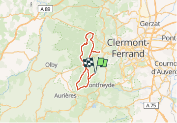
Tour Mountainbike von 42 km verfügbar auf Auvergne-Rhone-Alpen, Puy-de-Dôme, Saint-Genès-Champanelle. Diese Tour wird von duchaine.nicolas vorgeschlagen.
Beschreibung
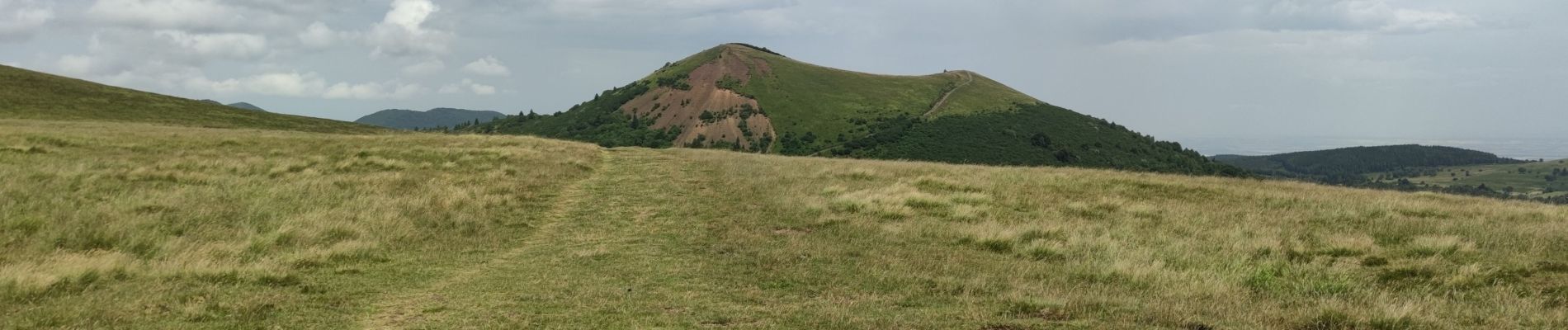
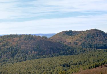
Belle balade entre les puys au départ de Beaune le Chaud en passant par le col de Ceyssat puis en tournant autour du Puy de Dome et du Puy Pariou. Le retour se fait par des puys plus au sud comme celui de Mercoeur ou de la Vache.
Ort
Land:
France
Region :
Auvergne-Rhone-Alpen
Abteilung/Provinz :
Puy-de-Dôme
Kommune :
Saint-Genès-Champanelle
Standort:
Unknown
Gehen Sie:(Dec)
Gehen Sie:(UTM)
499255 ; 5063707 (31T) N.
Kommentare
Touren in der Umgebung
![Tour Wandern Royat - Royat_Haut_Chamalieres - Photo](https://media.geolcdn.com/t/375/260/b2b61a3d-216c-41ca-b3c5-c12e3597cfee.jpg&format=jpg&maxdim=2)
![Wandern Wandern](https://static1.geolcdn.com/sitytour/trail-icons/101.png)
Royat_Haut_Chamalieres
Wandern
Medium
(2)
Royat,
Auvergne-Rhone-Alpen,
Puy-de-Dôme,
France
![](/images/other/stat-length.png)
10,8 km | 16,4 km-effort
3h 15min
![](https://static1.geolcdn.com/siteimages/upload/files/16400158638029165_repeat_loop_refresh_sync_direction_icon.png)
Ja
![Tour Wandern Royat - Royat_Paradis - Photo](https://media.geolcdn.com/t/375/260/40a920bf-98ae-44a7-8509-dbb3cd58b58b.jpg&format=jpg&maxdim=2)
![Wandern Wandern](https://static1.geolcdn.com/sitytour/trail-icons/101.png)
Royat_Paradis
Wandern
Einfach
(1)
Royat,
Auvergne-Rhone-Alpen,
Puy-de-Dôme,
France
![](/images/other/stat-length.png)
7,1 km | 10 km-effort
2h 15min
![](https://static1.geolcdn.com/siteimages/upload/files/16400158638029165_repeat_loop_refresh_sync_direction_icon.png)
Ja
![Tour Wandern Royat - Royat_Chemin_Ecoliers - Photo](https://media.geolcdn.com/t/375/260/45acbefc-a834-46ca-83ad-58408101e47d.jpg&format=jpg&maxdim=2)
![Wandern Wandern](https://static1.geolcdn.com/sitytour/trail-icons/101.png)
Royat_Chemin_Ecoliers
Wandern
Medium
(3)
Royat,
Auvergne-Rhone-Alpen,
Puy-de-Dôme,
France
![](/images/other/stat-length.png)
6,9 km | 11,2 km-effort
2h 0min
![](https://static1.geolcdn.com/siteimages/upload/files/16400158638029165_repeat_loop_refresh_sync_direction_icon.png)
Ja
![Tour Wandern Aydat - Lassolas-La Vache-Vichatel - Photo](https://media.geolcdn.com/t/375/260/ext.jpg?maxdim=2&url=https%3A%2F%2Fservices.sitytrail.com%2FGeolivesWS%2FDownloadMedia.ashx%3FTrailID%3D602562%26Media%3Dfix__20160723172634.jpg)
![Wandern Wandern](https://static1.geolcdn.com/sitytour/trail-icons/101.png)
Lassolas-La Vache-Vichatel
Wandern
Medium
(1)
Aydat,
Auvergne-Rhone-Alpen,
Puy-de-Dôme,
France
![](/images/other/stat-length.png)
13,2 km | 18,6 km-effort
4h 4min
![](https://static1.geolcdn.com/siteimages/upload/files/16400158638029165_repeat_loop_refresh_sync_direction_icon.png)
Ja
![Tour Wandern Orcines - Ceyssat_Puy_Dome - Photo](https://media.geolcdn.com/t/375/260/8756d4a5-24c7-4a55-b3cb-4d4af6c029f8.jpg&format=jpg&maxdim=2)
![Wandern Wandern](https://static1.geolcdn.com/sitytour/trail-icons/101.png)
Ceyssat_Puy_Dome
Wandern
Medium
(2)
Orcines,
Auvergne-Rhone-Alpen,
Puy-de-Dôme,
France
![](/images/other/stat-length.png)
7,3 km | 12,3 km-effort
2h 15min
![](https://static1.geolcdn.com/siteimages/upload/files/16400158638029165_repeat_loop_refresh_sync_direction_icon.png)
Ja
![Tour Wandern Aydat - Aydat_Montjuger_ST - Photo](https://media.geolcdn.com/t/375/260/c2caf5c0-1fa1-4013-81dc-2ab6f7f92569.jpg&format=jpg&maxdim=2)
![Wandern Wandern](https://static1.geolcdn.com/sitytour/trail-icons/101.png)
Aydat_Montjuger_ST
Wandern
Einfach
(1)
Aydat,
Auvergne-Rhone-Alpen,
Puy-de-Dôme,
France
![](/images/other/stat-length.png)
10,5 km | 12,7 km-effort
3h 0min
![](https://static1.geolcdn.com/siteimages/upload/files/16400158638029165_repeat_loop_refresh_sync_direction_icon.png)
Ja
![Wandern Wandern](https://static1.geolcdn.com/sitytour/trail-icons/101.png)
puy de Vichatel
Wandern
Sehr leicht
(1)
Aydat,
Auvergne-Rhone-Alpen,
Puy-de-Dôme,
France
![](/images/other/stat-length.png)
3,8 km | 5,8 km-effort
1h 13min
![](https://static1.geolcdn.com/siteimages/upload/files/16400158638029165_repeat_loop_refresh_sync_direction_icon.png)
Ja
![Tour Wandern Orcines - Le tour du Puy de Dôme - Photo](https://media.geolcdn.com/t/375/260/ext.jpg?maxdim=2&url=https%3A%2F%2Fservices.sitytrail.com%2FGeolivesWS%2FDownloadMedia.ashx%3FTrailID%3D102862%26Media%3D4049_1.jpg)
![Wandern Wandern](https://static1.geolcdn.com/sitytour/trail-icons/101.png)
Le tour du Puy de Dôme
Wandern
Schwierig
(1)
Orcines,
Auvergne-Rhone-Alpen,
Puy-de-Dôme,
France
![](/images/other/stat-length.png)
12,2 km | 17,3 km-effort
3h 0min
![](https://static1.geolcdn.com/siteimages/upload/files/16400158638029165_repeat_loop_refresh_sync_direction_icon.png)
Ja
![Tour Wandern Ceyssat - puy de dôme et périphérie - Photo](https://media.geolcdn.com/t/375/260/2d42b48f-ecf0-4816-ac26-6f6eefb103b2.jpg&format=jpg&maxdim=2)
![Wandern Wandern](https://static1.geolcdn.com/sitytour/trail-icons/101.png)
puy de dôme et périphérie
Wandern
Schwierig
Ceyssat,
Auvergne-Rhone-Alpen,
Puy-de-Dôme,
France
![](/images/other/stat-length.png)
11,1 km | 18 km-effort
6h 20min
![](https://static1.geolcdn.com/siteimages/upload/files/16400158638029165_repeat_loop_refresh_sync_direction_icon.png)
Nein