![](/images/other/stat-length.png)
![Tour Wandern Saint-Martin-Vésubie - Lac des Bresses et Nègre en boucle - Photo](https://media.geolcdn.com/t/1900/400/ext.pjpeg?maxdim=2&url=https%3A%2F%2Fstatic1.geolcdn.com%2Fsiteimages%2Fupload%2Ffiles%2F1553511878bg_sport_marche.png)
Lac des Bresses et Nègre en boucle
aris
Benutzer
![Länge](/images/other/stat-length.png)
![Maximale Höhe](https://static1.geolcdn.com/siteimages/upload/files/1508320355ic_sort_altitude_max_24dp.png)
![Positive Höhendifferenz](https://static1.geolcdn.com/siteimages/upload/files/1508320355ic_sort_den_pos_24dp.png)
![Km-Effort](/images/other/stat-length.png)
![Min. Höhe](https://static1.geolcdn.com/siteimages/upload/files/1508320355ic_sort_altitude_min_24dp.png)
![Negative Höhendifferenz](https://static1.geolcdn.com/siteimages/upload/files/1508320355ic_sort_den_neg_24dp.png)
![Boucle](https://static1.geolcdn.com/siteimages/upload/files/16400158638029165_repeat_loop_refresh_sync_direction_icon.png)
![Wandern](https://static1.geolcdn.com/sitytour/trail-icons/101.png)
5h57
Schwierigkeit : Medium
![Scannen Sie diesen QR-Code, um die Tour in der SityTrail-Anwendung zu öffnen](https://capi.geolives.com/qq0zvz2zws4bq2lad0pu/sitytour/trails/3286754/qr.png?size=200)
Kostenlosegpshiking-Anwendung
Über SityTrail
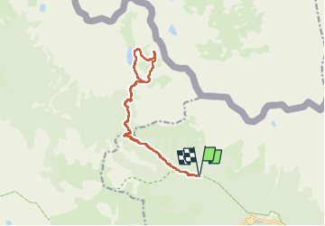
Tour Wandern von 15 km verfügbar auf Provence-Alpes-Côte d'Azur, Seealpen, Saint-Martin-Vésubie. Diese Tour wird von aris vorgeschlagen.
Beschreibung
Départ du sentier des lacs des Bresses indiqués par 2 cairns peu après Camp Soubran. L'itinéraire est peu marqué, quelques portions de sentiers et des cairns. Passages dans l'herbe, parfois raides.
Idem pour aller au second lac des Bresses, le cheminement est facile. Puis la baisse du lac Nègre, évidente, offre un joli panorama sur le lac inférieur des Bresses, et le pas de Préfouns. Un sentier (pas sur la carte) permet la descente (un peu raide) vers le lac Nègre.
Un joli tour, avec 3 lacs et de belles vues sur les crêtes environnantes.
Ort
Kommentare
Touren in der Umgebung
![Tour Wandern Saint-Martin-Vésubie - Lac de Trécolpas - Photo](https://media.geolcdn.com/t/375/260/ext.jpg?maxdim=2&url=https%3A%2F%2Fservices.sitytrail.com%2FGeolivesWS%2FDownloadMedia.ashx%3FTrailID%3D311062%26Media%3Dfix__20140607150849.jpg)
![Wandern Wandern](https://static1.geolcdn.com/sitytour/trail-icons/101.png)
Wandern
![](/images/other/stat-length.png)
![](https://static1.geolcdn.com/siteimages/upload/files/16400158638029165_repeat_loop_refresh_sync_direction_icon.png)
![Tour Wandern Saint-Martin-Vésubie - lacs bessons - Photo](https://media.geolcdn.com/t/375/260/a0e4b44d-1510-4e32-82be-e7e2ee548788.jpg&format=jpg&maxdim=2)
![Wandern Wandern](https://static1.geolcdn.com/sitytour/trail-icons/101.png)
Wandern
![](/images/other/stat-length.png)
![](https://static1.geolcdn.com/siteimages/upload/files/16400158638029165_repeat_loop_refresh_sync_direction_icon.png)
![Tour Wandern Saint-Martin-Vésubie - Lac Ne`gre bis - Photo](https://media.geolcdn.com/t/375/260/ext.jpg?maxdim=2&url=https%3A%2F%2Fservices.sitytrail.com%2FGeolivesWS%2FDownloadMedia.ashx%3FTrailID%3D733947%26Media%3D20170416133857.jpg)
![Wandern Wandern](https://static1.geolcdn.com/sitytour/trail-icons/101.png)
Wandern
![](/images/other/stat-length.png)
![](https://static1.geolcdn.com/siteimages/upload/files/16400158638029165_repeat_loop_refresh_sync_direction_icon.png)
![Tour Wandern Saint-Martin-Vésubie - Lac Trecolpas - Pas des Ladres - Col de Fenestre - Refuge Cougourde - Photo](https://media.geolcdn.com/t/375/260/541e5768-e182-4791-be6f-0df4a21d2a23.jpg&format=jpg&maxdim=2)
![Wandern Wandern](https://static1.geolcdn.com/sitytour/trail-icons/101.png)
Wandern
![](/images/other/stat-length.png)
![](https://static1.geolcdn.com/siteimages/upload/files/16400158638029165_repeat_loop_refresh_sync_direction_icon.png)
![Tour Zu Fuß Saint-Martin-Vésubie - Col de Cerise - Photo](https://media.geolcdn.com/t/375/260/90b1ce11-d155-4ca1-8f15-a1d1ec21efc7.jpeg&format=jpg&maxdim=2)
![Zu Fuß Zu Fuß](https://static1.geolcdn.com/sitytour/trail-icons/100.png)
Zu Fuß
![](/images/other/stat-length.png)
![](https://static1.geolcdn.com/siteimages/upload/files/16400158638029165_repeat_loop_refresh_sync_direction_icon.png)
![Tour Zu Fuß Saint-Martin-Vésubie - Circuit des Adus - Photo](https://media.geolcdn.com/t/375/260/1d6d9ad9-9540-40e2-b71d-1e8a26b80478.jpeg&format=jpg&maxdim=2)
![Zu Fuß Zu Fuß](https://static1.geolcdn.com/sitytour/trail-icons/100.png)
Zu Fuß
![](/images/other/stat-length.png)
![](https://static1.geolcdn.com/siteimages/upload/files/16400158638029165_repeat_loop_refresh_sync_direction_icon.png)
![Tour Zu Fuß Saint-Martin-Vésubie - Circuit de Trécolpas - Photo](https://media.geolcdn.com/t/375/260/f92e70c7-1f9c-4fa6-ae6b-2c614b3b921c.jpeg&format=jpg&maxdim=2)
![Zu Fuß Zu Fuß](https://static1.geolcdn.com/sitytour/trail-icons/100.png)
Zu Fuß
![](/images/other/stat-length.png)
![](https://static1.geolcdn.com/siteimages/upload/files/16400158638029165_repeat_loop_refresh_sync_direction_icon.png)
![Tour Zu Fuß Valdeblore - Lac Nègre - Photo](https://media.geolcdn.com/t/375/260/523722db-6e8e-40d3-b22f-f8992cf9694d.jpeg&format=jpg&maxdim=2)
![Zu Fuß Zu Fuß](https://static1.geolcdn.com/sitytour/trail-icons/100.png)
Zu Fuß
![](/images/other/stat-length.png)
![](https://static1.geolcdn.com/siteimages/upload/files/16400158638029165_repeat_loop_refresh_sync_direction_icon.png)
![Wandern Wandern](https://static1.geolcdn.com/sitytour/trail-icons/101.png)
Wandern
![](/images/other/stat-length.png)
![](https://static1.geolcdn.com/siteimages/upload/files/16400158638029165_repeat_loop_refresh_sync_direction_icon.png)