![](/images/other/stat-length.png)
20220609-Conches en Ouches
doudet
Benutzer
![Länge](/images/other/stat-length.png)
Länge
21 km
![Maximale Höhe](https://static1.geolcdn.com/siteimages/upload/files/1508320355ic_sort_altitude_max_24dp.png)
Maximale Höhe
160 m
![Positive Höhendifferenz](https://static1.geolcdn.com/siteimages/upload/files/1508320355ic_sort_den_pos_24dp.png)
Positive Höhendifferenz
269 m
![Km-Effort](/images/other/stat-length.png)
Km-Effort
24 km
![Min. Höhe](https://static1.geolcdn.com/siteimages/upload/files/1508320355ic_sort_altitude_min_24dp.png)
Min. Höhe
97 m
![Negative Höhendifferenz](https://static1.geolcdn.com/siteimages/upload/files/1508320355ic_sort_den_neg_24dp.png)
Negative Höhendifferenz
270 m
![Boucle](https://static1.geolcdn.com/siteimages/upload/files/16400158638029165_repeat_loop_refresh_sync_direction_icon.png)
Boucle
Ja
Erstellungsdatum :
2022-06-09 07:17:37.766
Letzte Änderung :
2022-06-11 14:47:22.056
![Wandern](https://static1.geolcdn.com/sitytour/trail-icons/101.png)
5h35
Schwierigkeit : Medium
![Scannen Sie diesen QR-Code, um die Tour in der SityTrail-Anwendung zu öffnen](https://capi.geolives.com/qq0zvz2zws4bq2lad0pu/sitytour/trails/3275854/qr.png?size=200)
Kostenlosegpshiking-Anwendung
Über SityTrail
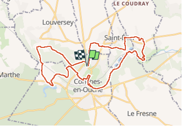
Tour Wandern von 21 km verfügbar auf Normandie, Eure, Conches-en-Ouche. Diese Tour wird von doudet vorgeschlagen.
Beschreibung
Boucle A-R au départ du cimetiere de Conches
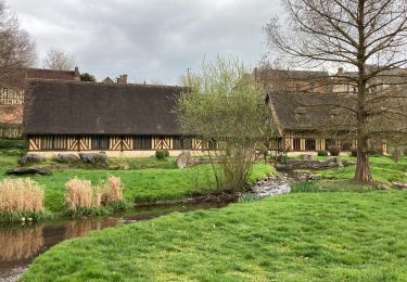
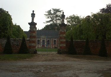
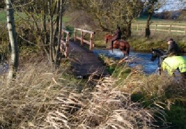
Ort
Land:
France
Region :
Normandie
Abteilung/Provinz :
Eure
Kommune :
Conches-en-Ouche
Standort:
Unknown
Gehen Sie:(Dec)
Gehen Sie:(UTM)
349293 ; 5426252 (31U) N.
Kommentare
Touren in der Umgebung
![Tour Wandern Conches-en-Ouche - conches - Photo](https://media.geolcdn.com/t/375/260/ext.jpg?maxdim=2&url=https%3A%2F%2Fstatic1.geolcdn.com%2Fsiteimages%2Fupload%2Ffiles%2F1553511878bg_sport_marche.png)
![Wandern Wandern](https://static1.geolcdn.com/sitytour/trail-icons/101.png)
conches
Wandern
Sehr leicht
(1)
Conches-en-Ouche,
Normandie,
Eure,
France
![](/images/other/stat-length.png)
13,9 km | 16,6 km-effort
Unbekannt
![](https://static1.geolcdn.com/siteimages/upload/files/16400158638029165_repeat_loop_refresh_sync_direction_icon.png)
Ja
![Tour Wandern Conches-en-Ouche - La vallée de rouloir - Photo](https://media.geolcdn.com/t/375/260/7422122c-1187-488a-911c-d4dca591b9d9.jpg&format=jpg&maxdim=2)
![Wandern Wandern](https://static1.geolcdn.com/sitytour/trail-icons/101.png)
La vallée de rouloir
Wandern
Einfach
Conches-en-Ouche,
Normandie,
Eure,
France
![](/images/other/stat-length.png)
11,6 km | 13,8 km-effort
3h 23min
![](https://static1.geolcdn.com/siteimages/upload/files/16400158638029165_repeat_loop_refresh_sync_direction_icon.png)
Ja
![Zu Fuß Zu Fuß](https://static1.geolcdn.com/sitytour/trail-icons/100.png)
Conches en Ouche
Zu Fuß
Einfach
Conches-en-Ouche,
Normandie,
Eure,
France
![](/images/other/stat-length.png)
21 km | 25 km-effort
Unbekannt
![](https://static1.geolcdn.com/siteimages/upload/files/16400158638029165_repeat_loop_refresh_sync_direction_icon.png)
Ja
![Tour Mountainbike Conches-en-Ouche - conches-ferrière sur risles - Photo](https://media.geolcdn.com/t/375/260/ext.jpg?maxdim=2&url=https%3A%2F%2Fservices.sitytrail.com%2FGeolivesWS%2FDownloadMedia.ashx%3FTrailID%3D448884%26Media%3Dfix__20140511115030.jpg)
![Mountainbike Mountainbike](https://static1.geolcdn.com/sitytour/trail-icons/202.png)
conches-ferrière sur risles
Mountainbike
Einfach
Conches-en-Ouche,
Normandie,
Eure,
France
![](/images/other/stat-length.png)
47 km | 53 km-effort
3h 26min
![](https://static1.geolcdn.com/siteimages/upload/files/16400158638029165_repeat_loop_refresh_sync_direction_icon.png)
Ja
![Tour Mountainbike Conches-en-Ouche - conches-ferrière sur risles - Photo](https://media.geolcdn.com/t/375/260/ext.jpg?maxdim=2&url=https%3A%2F%2Fservices.sitytrail.com%2FGeolivesWS%2FDownloadMedia.ashx%3FTrailID%3D285571%26Media%3Dfix__20140511115030.jpg)
![Mountainbike Mountainbike](https://static1.geolcdn.com/sitytour/trail-icons/202.png)
conches-ferrière sur risles
Mountainbike
Einfach
Conches-en-Ouche,
Normandie,
Eure,
France
![](/images/other/stat-length.png)
47 km | 53 km-effort
3h 26min
![](https://static1.geolcdn.com/siteimages/upload/files/16400158638029165_repeat_loop_refresh_sync_direction_icon.png)
Ja
![Tour Pferd La Croisille - les boscherons - Photo](https://media.geolcdn.com/t/375/260/ext.jpg?maxdim=2&url=https%3A%2F%2Fservices.sitytrail.com%2FGeolivesWS%2FDownloadMedia.ashx%3FTrailID%3D238492%26Media%3Dfix__20131222113833.jpg)
![Pferd Pferd](https://static1.geolcdn.com/sitytour/trail-icons/300.png)
![Tour Wandern Conches-en-Ouche - Conches en Ouche, Chanteloup, Collandres,vieux Conches 24 kms - Photo](https://media.geolcdn.com/t/375/260/ext.jpg?maxdim=2&url=https%3A%2F%2Fstatic1.geolcdn.com%2Fsiteimages%2Fupload%2Ffiles%2F1553511878bg_sport_marche.png)
![Wandern Wandern](https://static1.geolcdn.com/sitytour/trail-icons/101.png)
Conches en Ouche, Chanteloup, Collandres,vieux Conches 24 kms
Wandern
Sehr schwierig
Conches-en-Ouche,
Normandie,
Eure,
France
![](/images/other/stat-length.png)
24 km | 27 km-effort
6h 7min
![](https://static1.geolcdn.com/siteimages/upload/files/16400158638029165_repeat_loop_refresh_sync_direction_icon.png)
Ja
![Tour Wandern Conches-en-Ouche - Sur la route de Compostelle autour de Conches 11 kms - Photo](https://media.geolcdn.com/t/375/260/ext.jpg?maxdim=2&url=https%3A%2F%2Fstatic1.geolcdn.com%2Fsiteimages%2Fupload%2Ffiles%2F1553511878bg_sport_marche.png)
![Wandern Wandern](https://static1.geolcdn.com/sitytour/trail-icons/101.png)
Sur la route de Compostelle autour de Conches 11 kms
Wandern
Schwierig
Conches-en-Ouche,
Normandie,
Eure,
France
![](/images/other/stat-length.png)
10,7 km | 12,8 km-effort
2h 55min
![](https://static1.geolcdn.com/siteimages/upload/files/16400158638029165_repeat_loop_refresh_sync_direction_icon.png)
Ja
![Tour Wandern Conches-en-Ouche - Conches en Ouche, sur la route de compostelle - Photo](https://media.geolcdn.com/t/375/260/ext.jpg?maxdim=2&url=https%3A%2F%2Fstatic1.geolcdn.com%2Fsiteimages%2Fupload%2Ffiles%2F1553511878bg_sport_marche.png)
![Wandern Wandern](https://static1.geolcdn.com/sitytour/trail-icons/101.png)
Conches en Ouche, sur la route de compostelle
Wandern
Schwierig
Conches-en-Ouche,
Normandie,
Eure,
France
![](/images/other/stat-length.png)
15 km | 17,8 km-effort
4h 2min
![](https://static1.geolcdn.com/siteimages/upload/files/16400158638029165_repeat_loop_refresh_sync_direction_icon.png)
Ja