![](/images/other/stat-length.png)
![Tour Wandern Vignec - Cap de la Pede 10/05/22 - Photo](https://media.geolcdn.com/t/1900/400/ext.pjpeg?maxdim=2&url=https%3A%2F%2Fstatic1.geolcdn.com%2Fsiteimages%2Fupload%2Ffiles%2F1553511878bg_sport_marche.png)
Cap de la Pede 10/05/22
mitch1952
Benutzer
![Länge](/images/other/stat-length.png)
![Maximale Höhe](https://static1.geolcdn.com/siteimages/upload/files/1508320355ic_sort_altitude_max_24dp.png)
![Positive Höhendifferenz](https://static1.geolcdn.com/siteimages/upload/files/1508320355ic_sort_den_pos_24dp.png)
![Km-Effort](/images/other/stat-length.png)
![Min. Höhe](https://static1.geolcdn.com/siteimages/upload/files/1508320355ic_sort_altitude_min_24dp.png)
![Negative Höhendifferenz](https://static1.geolcdn.com/siteimages/upload/files/1508320355ic_sort_den_neg_24dp.png)
![Boucle](https://static1.geolcdn.com/siteimages/upload/files/16400158638029165_repeat_loop_refresh_sync_direction_icon.png)
![Wandern](https://static1.geolcdn.com/sitytour/trail-icons/101.png)
6h06
Schwierigkeit : Sehr schwierig
![Scannen Sie diesen QR-Code, um die Tour in der SityTrail-Anwendung zu öffnen](https://capi.geolives.com/qq0zvz2zws4bq2lad0pu/sitytour/trails/3272193/qr.png?size=200)
Kostenlosegpshiking-Anwendung
Über SityTrail
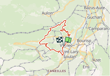
Tour Wandern von 14,1 km verfügbar auf Okzitanien, Hautes-Pyrénées, Vignec. Diese Tour wird von mitch1952 vorgeschlagen.
Beschreibung
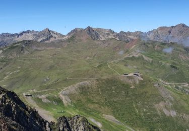
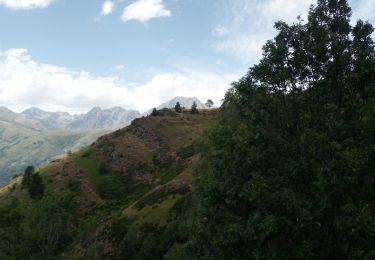
Magnifique journée pour aller au Cap de la Pede et poursuivre jusqu'aux granges du Grascouéou. La montée est assez soutenue, mais le visuel est au rendez-vous. L'Arbizon tout proche est encore pris par la neige. Panorama superbe .Arbizon , Petit Arbizon, Pic d'Aulon,Pic de Portarras, Pichaley,Montarrouyes,Soum de Mattes, Pic d'Arrouye, Pic d'Aret, Pic de Clarabide,Pic de Sarrouyes,Pic d'Espingo etc etc...et on ne peut pas tous les connaître !!! Super journée, et très chaude
Ort
Kommentare
Touren in der Umgebung
![Tour Wandern Saint-Lary-Soulan - 2011-08-03 15h51m06 - Photo](https://media.geolcdn.com/t/375/260/ext.jpg?maxdim=2&url=https%3A%2F%2Fservices.sitytrail.com%2FGeolivesWS%2FDownloadMedia.ashx%3FTrailID%3D70666%26Media%3D20110803154635.jpeg)
![Wandern Wandern](https://static1.geolcdn.com/sitytour/trail-icons/101.png)
Wandern
![](/images/other/stat-length.png)
![](https://static1.geolcdn.com/siteimages/upload/files/16400158638029165_repeat_loop_refresh_sync_direction_icon.png)
![Tour Wandern Ens - lacs de Consaterre - Photo](https://media.geolcdn.com/t/375/260/ext.jpg?maxdim=2&url=https%3A%2F%2Fstatic1.geolcdn.com%2Fsiteimages%2Fupload%2Ffiles%2F1553511878bg_sport_marche.png)
![Wandern Wandern](https://static1.geolcdn.com/sitytour/trail-icons/101.png)
Wandern
![](/images/other/stat-length.png)
![](https://static1.geolcdn.com/siteimages/upload/files/16400158638029165_repeat_loop_refresh_sync_direction_icon.png)
![Tour Wandern Saint-Lary-Soulan - Pène-Male par les crêtes de Heche-Barrade - Photo](https://media.geolcdn.com/t/375/260/de632eea-ef64-4a92-92e4-bd24316e8942.jpg&format=jpg&maxdim=2)
![Wandern Wandern](https://static1.geolcdn.com/sitytour/trail-icons/101.png)
Wandern
![](/images/other/stat-length.png)
![](https://static1.geolcdn.com/siteimages/upload/files/16400158638029165_repeat_loop_refresh_sync_direction_icon.png)
![Tour Wandern Azet - 2023-09-10 Azet-Col d'Azet crète de la Serre - Photo](https://media.geolcdn.com/t/375/260/a241488d-7806-4d31-8df1-c552ae8f09f7.jpg&format=jpg&maxdim=2)
![Wandern Wandern](https://static1.geolcdn.com/sitytour/trail-icons/101.png)
Wandern
![](/images/other/stat-length.png)
![](https://static1.geolcdn.com/siteimages/upload/files/16400158638029165_repeat_loop_refresh_sync_direction_icon.png)
![Tour sport Tramezaïgues - Au dessus de tramezaigues - Photo](https://media.geolcdn.com/t/375/260/6241ad0b-d07e-4c7e-b6a4-b04d00176721.jpg&format=jpg&maxdim=2)
sport
![](/images/other/stat-length.png)
![](https://static1.geolcdn.com/siteimages/upload/files/16400158638029165_repeat_loop_refresh_sync_direction_icon.png)
![Tour Wandern Saint-Lary-Soulan - AZET : Pla d’Ourtigué en boucle - Photo](https://media.geolcdn.com/t/375/260/61d95884-b483-4a11-b2a1-350e3c3e812e.jpg&format=jpg&maxdim=2)
![Wandern Wandern](https://static1.geolcdn.com/sitytour/trail-icons/101.png)
Wandern
![](/images/other/stat-length.png)
![](https://static1.geolcdn.com/siteimages/upload/files/16400158638029165_repeat_loop_refresh_sync_direction_icon.png)
![Tour Wandern Saint-Lary-Soulan - Vieille Aure-Trachère - Photo](https://media.geolcdn.com/t/375/260/939f9075-2a66-47f6-ada4-2a25ac95fa43.jpg&format=jpg&maxdim=2)
![Wandern Wandern](https://static1.geolcdn.com/sitytour/trail-icons/101.png)
Wandern
![](/images/other/stat-length.png)
![](https://static1.geolcdn.com/siteimages/upload/files/16400158638029165_repeat_loop_refresh_sync_direction_icon.png)
![Tour Zu Fuß Saint-Lary-Soulan - Boucle de Caneilles - Photo](https://media.geolcdn.com/t/375/260/0b78c8a6-531b-4e32-888c-f6bec383597c.jpeg&format=jpg&maxdim=2)
![Zu Fuß Zu Fuß](https://static1.geolcdn.com/sitytour/trail-icons/100.png)
Zu Fuß
![](/images/other/stat-length.png)
![](https://static1.geolcdn.com/siteimages/upload/files/16400158638029165_repeat_loop_refresh_sync_direction_icon.png)
![Tour Wandern Bourisp - GR 10 - 27ème étape : Vielle Aure - Bourisp - Azet - Col d’Azet - Loudenvielle Germ - Photo](https://media.geolcdn.com/t/375/260/9fd82e7e-8a4b-45f0-b25e-68a07f11d343.jpg&format=jpg&maxdim=2)
![Wandern Wandern](https://static1.geolcdn.com/sitytour/trail-icons/101.png)
Wandern
![](/images/other/stat-length.png)
![](https://static1.geolcdn.com/siteimages/upload/files/16400158638029165_repeat_loop_refresh_sync_direction_icon.png)