![](/images/other/stat-length.png)
![Tour Wandern Monêtier-Allemont - le pic de Crigne - Photo](https://media.geolcdn.com/t/1900/400/3216e3ac-fa23-434c-aac1-d06a9982e5b1.jpg&format=pjpeg&maxdim=2)
le pic de Crigne
amiral13
Benutzer GUIDE
![Länge](/images/other/stat-length.png)
![Maximale Höhe](https://static1.geolcdn.com/siteimages/upload/files/1508320355ic_sort_altitude_max_24dp.png)
![Positive Höhendifferenz](https://static1.geolcdn.com/siteimages/upload/files/1508320355ic_sort_den_pos_24dp.png)
![Km-Effort](/images/other/stat-length.png)
![Min. Höhe](https://static1.geolcdn.com/siteimages/upload/files/1508320355ic_sort_altitude_min_24dp.png)
![Negative Höhendifferenz](https://static1.geolcdn.com/siteimages/upload/files/1508320355ic_sort_den_neg_24dp.png)
![Boucle](https://static1.geolcdn.com/siteimages/upload/files/16400158638029165_repeat_loop_refresh_sync_direction_icon.png)
![Wandern](https://static1.geolcdn.com/sitytour/trail-icons/101.png)
3h27
Schwierigkeit : Schwierig
![Scannen Sie diesen QR-Code, um die Tour in der SityTrail-Anwendung zu öffnen](https://capi.geolives.com/qq0zvz2zws4bq2lad0pu/sitytour/trails/3269400/qr.png?size=200)
Kostenlosegpshiking-Anwendung
Über SityTrail
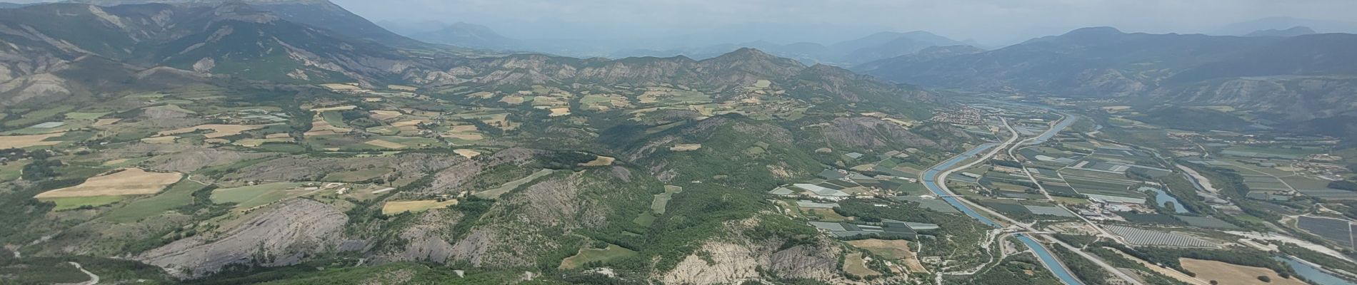
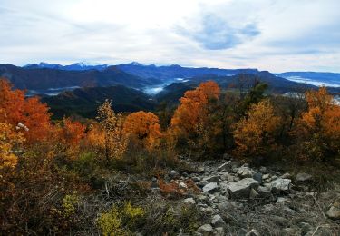
Tour Wandern von 5,6 km verfügbar auf Provence-Alpes-Côte d'Azur, Hochalpen, Monêtier-Allemont. Diese Tour wird von amiral13 vorgeschlagen.
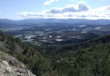
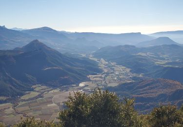
Beschreibung
un beau belvédère.
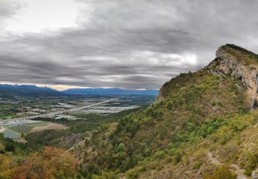
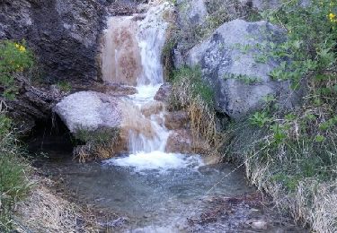
attention par forte chaleur, c'est un véritable four; à éviter en été.
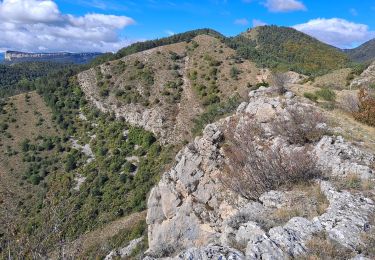
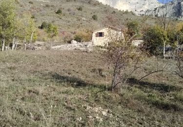
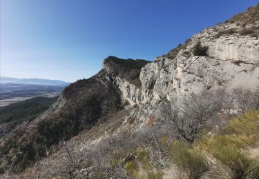
Au dessus de la bergerie il n'y a pas de sentier. arriver à la barre rocheuse quelques passages nécessitent l'utilisation des mains dont un exposé (emmener un bout de corde si vous avez des personnes inexpérimentées avec vous).
Ort
Kommentare
Touren in der Umgebung
![Tour Wandern Vitrolles - Pic de Crigne - Photo](https://media.geolcdn.com/t/375/260/8de24f96-abb9-4a59-92c3-86b70c658bb0.jpg&format=jpg&maxdim=2)
![Wandern Wandern](https://static1.geolcdn.com/sitytour/trail-icons/101.png)
Wandern
![](/images/other/stat-length.png)
![](https://static1.geolcdn.com/siteimages/upload/files/16400158638029165_repeat_loop_refresh_sync_direction_icon.png)
![Tour Wandern Ventavon - col des selles vers pic de crigne - Photo](https://media.geolcdn.com/t/375/260/e38de5f2-bcbf-465e-9709-6640d810ac1b.jpg&format=jpg&maxdim=2)
![Wandern Wandern](https://static1.geolcdn.com/sitytour/trail-icons/101.png)
Wandern
![](/images/other/stat-length.png)
![](https://static1.geolcdn.com/siteimages/upload/files/16400158638029165_repeat_loop_refresh_sync_direction_icon.png)
![Tour Wandern Monêtier-Allemont - pic de Crigne - Photo](https://media.geolcdn.com/t/375/260/4385029e-383e-41cf-87d5-306f1333b6ec.jpg&format=jpg&maxdim=2)
![Wandern Wandern](https://static1.geolcdn.com/sitytour/trail-icons/101.png)
Wandern
![](/images/other/stat-length.png)
![](https://static1.geolcdn.com/siteimages/upload/files/16400158638029165_repeat_loop_refresh_sync_direction_icon.png)
![Tour Wandern Melve - Melve Les Chanderettes 1014m 16kms - Photo](https://media.geolcdn.com/t/375/260/ccabf33a-e431-4ec0-8bfa-bcf63e55d70b.jpg&format=jpg&maxdim=2)
![Wandern Wandern](https://static1.geolcdn.com/sitytour/trail-icons/101.png)
Wandern
![](/images/other/stat-length.png)
![](https://static1.geolcdn.com/siteimages/upload/files/16400158638029165_repeat_loop_refresh_sync_direction_icon.png)
![Tour Wandern Vitrolles - Pic de Crigne - Photo](https://media.geolcdn.com/t/375/260/c57ec1d9-7b0a-459e-886f-cd7864baade1.jpg&format=jpg&maxdim=2)
![Wandern Wandern](https://static1.geolcdn.com/sitytour/trail-icons/101.png)
Wandern
![](/images/other/stat-length.png)
![](https://static1.geolcdn.com/siteimages/upload/files/16400158638029165_repeat_loop_refresh_sync_direction_icon.png)
![Tour Wandern Monêtier-Allemont - SityTrail - Pic de Crigne. - Photo](https://media.geolcdn.com/t/375/260/e57e7c6e-7b24-471d-a732-1162a0342581.jpg&format=jpg&maxdim=2)
![Wandern Wandern](https://static1.geolcdn.com/sitytour/trail-icons/101.png)
Wandern
![](/images/other/stat-length.png)
![](https://static1.geolcdn.com/siteimages/upload/files/16400158638029165_repeat_loop_refresh_sync_direction_icon.png)
![Tour Wandern Claret - Tete de Boursier depart Claret - Photo](https://media.geolcdn.com/t/375/260/c93a942b-9518-4b3c-80a9-c6f6ef8e8c48.jpg&format=jpg&maxdim=2)
![Wandern Wandern](https://static1.geolcdn.com/sitytour/trail-icons/101.png)
Wandern
![](/images/other/stat-length.png)
![](https://static1.geolcdn.com/siteimages/upload/files/16400158638029165_repeat_loop_refresh_sync_direction_icon.png)
![Tour Wandern Melve - 20191126_Melve Tête de Boursier - Photo](https://media.geolcdn.com/t/375/260/1d6a6e93-136f-4ae8-96da-7f5812d2bd56.jpg&format=jpg&maxdim=2)
![Wandern Wandern](https://static1.geolcdn.com/sitytour/trail-icons/101.png)
Wandern
![](/images/other/stat-length.png)
![](https://static1.geolcdn.com/siteimages/upload/files/16400158638029165_repeat_loop_refresh_sync_direction_icon.png)
![Tour Wandern Monêtier-Allemont - Pic de Crigne. - Photo](https://media.geolcdn.com/t/375/260/ext.jpg?maxdim=2&url=https%3A%2F%2Fservices.sitytrail.com%2FGeolivesWS%2FDownloadMedia.ashx%3FTrailID%3D748107%26Media%3Dfix__20170507181655.jpg)
![Wandern Wandern](https://static1.geolcdn.com/sitytour/trail-icons/101.png)
Wandern
![](/images/other/stat-length.png)
![](https://static1.geolcdn.com/siteimages/upload/files/16400158638029165_repeat_loop_refresh_sync_direction_icon.png)