![](/images/other/stat-length.png)
![Tour Wandern Beuil - Tête de Pommier Baisse de Clari les Cluots Giarons par Pinea - Photo](https://media.geolcdn.com/t/1900/400/ae4f7249-ce8f-4abc-b988-f565065cc5ff.jpg&format=pjpeg&maxdim=2)
Tête de Pommier Baisse de Clari les Cluots Giarons par Pinea
GrouGary
Benutzer
![Länge](/images/other/stat-length.png)
![Maximale Höhe](https://static1.geolcdn.com/siteimages/upload/files/1508320355ic_sort_altitude_max_24dp.png)
![Positive Höhendifferenz](https://static1.geolcdn.com/siteimages/upload/files/1508320355ic_sort_den_pos_24dp.png)
![Km-Effort](/images/other/stat-length.png)
![Min. Höhe](https://static1.geolcdn.com/siteimages/upload/files/1508320355ic_sort_altitude_min_24dp.png)
![Negative Höhendifferenz](https://static1.geolcdn.com/siteimages/upload/files/1508320355ic_sort_den_neg_24dp.png)
![Boucle](https://static1.geolcdn.com/siteimages/upload/files/16400158638029165_repeat_loop_refresh_sync_direction_icon.png)
![Wandern](https://static1.geolcdn.com/sitytour/trail-icons/101.png)
6h12
Schwierigkeit : Medium
![Scannen Sie diesen QR-Code, um die Tour in der SityTrail-Anwendung zu öffnen](https://capi.geolives.com/qq0zvz2zws4bq2lad0pu/sitytour/trails/3259522/qr.png?size=200)
Kostenlosegpshiking-Anwendung
Über SityTrail
Tour Wandern von 15,2 km verfügbar auf Provence-Alpes-Côte d'Azur, Seealpen, Beuil. Diese Tour wird von GrouGary vorgeschlagen.
Beschreibung
Boucle idéale pour les fleurs du printemps et la douce température des Cluots, comparée à la chaleur qui s'installe dans le Sud.
Du parking "pré de chaudi", monter par Pommier dans les sous bois. Continuer sur Tête de Pommier puis Baisse de Clari. Vue superbe sur Mt Mounier, Tête de Rigaut...
Sur les mamelons verts et florifères, se diriger vers les Cluots (bergerie et coral) ; Pic-nic au sommet. Contourner Giarons à la balise 76, direction les ruines de Giarons.
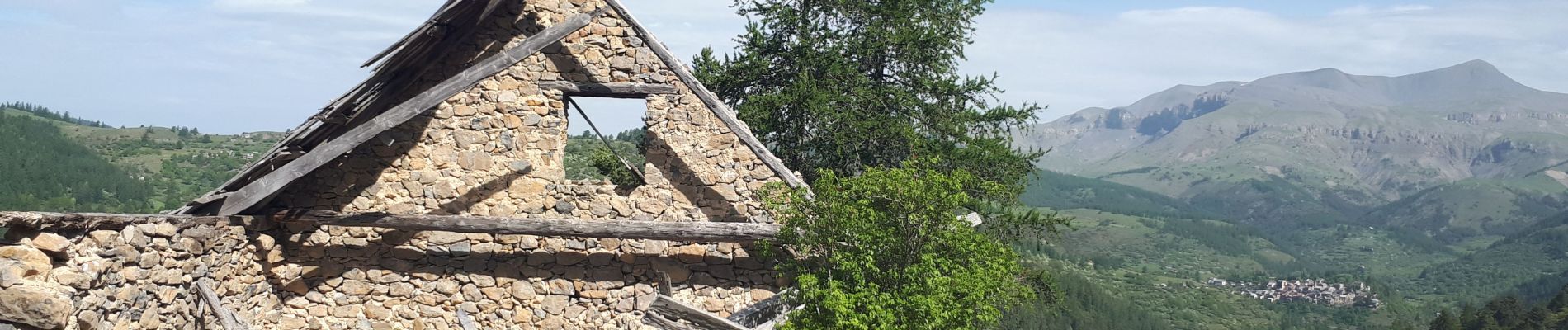
A l'oratoire de Giarons, se diriger vers la grosse maison en ruine et suivre les nouvelles balises jaunes de la descente de "Giarons par Pinea".
R : Le sentier qui passe en balcon au-dessus des barres de l'Ablé n'est plus balisé au-delà de la bergerie et source (sentiers bouchés par les genêts...)
Ort
Kommentare
Touren in der Umgebung
![Tour Schneeschuhwandern Beuil - Beuil :Rando raquettes (Aller) - Photo](https://media.geolcdn.com/t/375/260/ext.jpg?maxdim=2&url=https%3A%2F%2Fservices.sitytrail.com%2FGeolivesWS%2FDownloadMedia.ashx%3FTrailID%3D251398%26Media%3Dfix__20140221123121.jpg)
![Schneeschuhwandern Schneeschuhwandern](https://static1.geolcdn.com/sitytour/trail-icons/504.png)
Schneeschuhwandern
![](/images/other/stat-length.png)
![](https://static1.geolcdn.com/siteimages/upload/files/16400158638029165_repeat_loop_refresh_sync_direction_icon.png)
![Tour Zu Fuß Guillaumes - Sentier Planétaire - Photo](https://media.geolcdn.com/t/375/260/e96398fb-c06d-4a8f-b157-fc349cbf3cc7.jpeg&format=jpg&maxdim=2)
![Zu Fuß Zu Fuß](https://static1.geolcdn.com/sitytour/trail-icons/100.png)
Zu Fuß
![](/images/other/stat-length.png)
![](https://static1.geolcdn.com/siteimages/upload/files/16400158638029165_repeat_loop_refresh_sync_direction_icon.png)
![Tour Zu Fuß Beuil - Tête du Garnier - Photo](https://media.geolcdn.com/t/375/260/8afc2979-1909-4f36-ba82-f331af4dab5f.jpeg&format=jpg&maxdim=2)
![Zu Fuß Zu Fuß](https://static1.geolcdn.com/sitytour/trail-icons/100.png)
Zu Fuß
![](/images/other/stat-length.png)
![](https://static1.geolcdn.com/siteimages/upload/files/16400158638029165_repeat_loop_refresh_sync_direction_icon.png)
![Tour Zu Fuß Beuil - Corniches du Cians - Photo](https://media.geolcdn.com/t/375/260/df9224fd-ed5d-4e0e-98e6-95eb532acfaf.jpeg&format=jpg&maxdim=2)
![Zu Fuß Zu Fuß](https://static1.geolcdn.com/sitytour/trail-icons/100.png)
Zu Fuß
![](/images/other/stat-length.png)
![](https://static1.geolcdn.com/siteimages/upload/files/16400158638029165_repeat_loop_refresh_sync_direction_icon.png)
![Tour Zu Fuß Péone - Mont Mounier - Photo](https://media.geolcdn.com/t/375/260/0744a5ed-7dbe-4b82-ab9f-b5b91c9c9b14.jpeg&format=jpg&maxdim=2)
![Zu Fuß Zu Fuß](https://static1.geolcdn.com/sitytour/trail-icons/100.png)
Zu Fuß
![](/images/other/stat-length.png)
![](https://static1.geolcdn.com/siteimages/upload/files/16400158638029165_repeat_loop_refresh_sync_direction_icon.png)
![Tour Zu Fuß Pierlas - Tour du Mont de Lieuche - Photo](https://media.geolcdn.com/t/375/260/21b88e85-708c-4489-9ada-9348a7269087.jpeg&format=jpg&maxdim=2)
![Zu Fuß Zu Fuß](https://static1.geolcdn.com/sitytour/trail-icons/100.png)
Zu Fuß
![](/images/other/stat-length.png)
![](https://static1.geolcdn.com/siteimages/upload/files/16400158638029165_repeat_loop_refresh_sync_direction_icon.png)
![Tour Wandern Beuil - Gorges du Cians - AR sur les corniches - Photo](https://media.geolcdn.com/t/375/260/ext.jpg?maxdim=2&url=https%3A%2F%2Fservices.sitytrail.com%2FGeolivesWS%2FDownloadMedia.ashx%3FTrailID%3D348549%26Media%3Dfix__20140926113514.jpg)
![Wandern Wandern](https://static1.geolcdn.com/sitytour/trail-icons/101.png)
Wandern
![](/images/other/stat-length.png)
![](https://static1.geolcdn.com/siteimages/upload/files/16400158638029165_repeat_loop_refresh_sync_direction_icon.png)
![Tour Schneeschuhwandern Roubion - Couillole Mt Brussière - Photo](https://media.geolcdn.com/t/375/260/ext.jpg?maxdim=2&url=https%3A%2F%2Fstatic1.geolcdn.com%2Fsiteimages%2Fupload%2Ffiles%2F1524743153raquette.jpg)
![Schneeschuhwandern Schneeschuhwandern](https://static1.geolcdn.com/sitytour/trail-icons/504.png)
Schneeschuhwandern
![](/images/other/stat-length.png)
![](https://static1.geolcdn.com/siteimages/upload/files/16400158638029165_repeat_loop_refresh_sync_direction_icon.png)
![Tour Wandern Beuil - corniche du CIANS - Photo](https://media.geolcdn.com/t/375/260/ext.jpg?maxdim=2&url=https%3A%2F%2Fstatic1.geolcdn.com%2Fsiteimages%2Fupload%2Ffiles%2F1553511878bg_sport_marche.png)
![Wandern Wandern](https://static1.geolcdn.com/sitytour/trail-icons/101.png)
Wandern
![](/images/other/stat-length.png)
![](https://static1.geolcdn.com/siteimages/upload/files/16400158638029165_repeat_loop_refresh_sync_direction_icon.png)