![](/images/other/stat-length.png)
![Tour Wandern Laroquebrou - Montmiole- Laroquebrou-Puech Mezerie- Gresse- La Margide - Photo](https://media.geolcdn.com/t/1900/400/ext.pjpeg?maxdim=2&url=https%3A%2F%2Fstatic1.geolcdn.com%2Fsiteimages%2Fupload%2Ffiles%2F1553511878bg_sport_marche.png)
Montmiole- Laroquebrou-Puech Mezerie- Gresse- La Margide
delzonsgeraud
Benutzer
![Länge](/images/other/stat-length.png)
Länge
10,8 km
![Maximale Höhe](https://static1.geolcdn.com/siteimages/upload/files/1508320355ic_sort_altitude_max_24dp.png)
Maximale Höhe
593 m
![Positive Höhendifferenz](https://static1.geolcdn.com/siteimages/upload/files/1508320355ic_sort_den_pos_24dp.png)
Positive Höhendifferenz
265 m
![Km-Effort](/images/other/stat-length.png)
Km-Effort
14,4 km
![Min. Höhe](https://static1.geolcdn.com/siteimages/upload/files/1508320355ic_sort_altitude_min_24dp.png)
Min. Höhe
467 m
![Negative Höhendifferenz](https://static1.geolcdn.com/siteimages/upload/files/1508320355ic_sort_den_neg_24dp.png)
Negative Höhendifferenz
267 m
![Boucle](https://static1.geolcdn.com/siteimages/upload/files/16400158638029165_repeat_loop_refresh_sync_direction_icon.png)
Boucle
Ja
Erstellungsdatum :
2022-05-14 11:49:11.107
Letzte Änderung :
2022-05-14 15:48:10.971
![Wandern](https://static1.geolcdn.com/sitytour/trail-icons/101.png)
3h08
Schwierigkeit : Schwierig
![Scannen Sie diesen QR-Code, um die Tour in der SityTrail-Anwendung zu öffnen](https://capi.geolives.com/qq0zvz2zws4bq2lad0pu/sitytour/trails/3241973/qr.png?size=200)
Kostenlosegpshiking-Anwendung
Über SityTrail
Tour Wandern von 10,8 km verfügbar auf Auvergne-Rhone-Alpen, Cantal, Laroquebrou. Diese Tour wird von delzonsgeraud vorgeschlagen.
Beschreibung
Départ au carrefour des routes de La Margide et de Montmiole. A faire plutôt quand le ciel est couvert car il y a beaucoup de trajet non couvert par la végétation.
Ort
Land:
France
Region :
Auvergne-Rhone-Alpen
Abteilung/Provinz :
Cantal
Kommune :
Laroquebrou
Standort:
Unknown
Gehen Sie:(Dec)
Gehen Sie:(UTM)
438981 ; 4979505 (31T) N.
Kommentare
Touren in der Umgebung
![Tour Rennrad Laroquebrou - Laroquebrou circuit autour du lac - Photo](https://media.geolcdn.com/t/375/260/47b459ad-488f-4622-9aec-eab65f4f4266.jpg&format=jpg&maxdim=2)
![Rennrad Rennrad](https://static1.geolcdn.com/sitytour/trail-icons/201.png)
Laroquebrou circuit autour du lac
Rennrad
Medium
Laroquebrou,
Auvergne-Rhone-Alpen,
Cantal,
France
![](/images/other/stat-length.png)
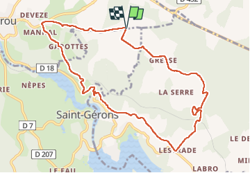
39 km | 50 km-effort
2h 15min
![](https://static1.geolcdn.com/siteimages/upload/files/16400158638029165_repeat_loop_refresh_sync_direction_icon.png)
Ja
![Tour Wandern Lacapelle-Viescamp - Boucle du Marais Cassan Calvanhac - Photo](https://media.geolcdn.com/t/375/260/604c97cb-4f46-44e4-9231-717e385b787a.jpg&format=jpg&maxdim=2)
![Wandern Wandern](https://static1.geolcdn.com/sitytour/trail-icons/101.png)
Boucle du Marais Cassan Calvanhac
Wandern
Einfach
Lacapelle-Viescamp,
Auvergne-Rhone-Alpen,
Cantal,
France
![](/images/other/stat-length.png)
15,2 km | 18,1 km-effort
3h 23min
![](https://static1.geolcdn.com/siteimages/upload/files/16400158638029165_repeat_loop_refresh_sync_direction_icon.png)
Ja
![Tour Wandern Laroquebrou - La Via Arverna (Laroquebrou - Camps-Saint-Mathurin) - Photo](https://media.geolcdn.com/t/375/260/ext.jpg?maxdim=2&url=https%3A%2F%2Fservices.sitytrail.com%2FGeolivesWS%2FDownloadMedia.ashx%3FTrailID%3D173260%26Media%3D14876_6.jpg)
![Wandern Wandern](https://static1.geolcdn.com/sitytour/trail-icons/101.png)
La Via Arverna (Laroquebrou - Camps-Saint-Mathurin)
Wandern
Schwierig
Laroquebrou,
Auvergne-Rhone-Alpen,
Cantal,
France
![](/images/other/stat-length.png)
24 km | 34 km-effort
7h 30min
![](https://static1.geolcdn.com/siteimages/upload/files/16400158638029165_repeat_loop_refresh_sync_direction_icon.png)
Nein
![Tour Wandern Nieudan - Cas 11 bis - Photo](https://media.geolcdn.com/t/375/260/ext.jpg?maxdim=2&url=https%3A%2F%2Fstatic1.geolcdn.com%2Fsiteimages%2Fupload%2Ffiles%2F1553511878bg_sport_marche.png)
![Wandern Wandern](https://static1.geolcdn.com/sitytour/trail-icons/101.png)
Cas 11 bis
Wandern
Medium
Nieudan,
Auvergne-Rhone-Alpen,
Cantal,
France
![](/images/other/stat-length.png)
7,1 km | 9,3 km-effort
3h 6min
![](https://static1.geolcdn.com/siteimages/upload/files/16400158638029165_repeat_loop_refresh_sync_direction_icon.png)
Ja
![Tour Wandern Nieudan - Le Meyrou - Photo](https://media.geolcdn.com/t/375/260/ext.jpg?maxdim=2&url=https%3A%2F%2Fstatic1.geolcdn.com%2Fsiteimages%2Fupload%2Ffiles%2F1553511878bg_sport_marche.png)
![Wandern Wandern](https://static1.geolcdn.com/sitytour/trail-icons/101.png)
Le Meyrou
Wandern
Medium
Nieudan,
Auvergne-Rhone-Alpen,
Cantal,
France
![](/images/other/stat-length.png)
6,9 km | 8,7 km-effort
3h 8min
![](https://static1.geolcdn.com/siteimages/upload/files/16400158638029165_repeat_loop_refresh_sync_direction_icon.png)
Nein
![Tour Wandern Nieudan - Les Garrigues Laveissiere Le Meyniel - Photo](https://media.geolcdn.com/t/375/260/ext.jpg?maxdim=2&url=https%3A%2F%2Fstatic1.geolcdn.com%2Fsiteimages%2Fupload%2Ffiles%2F1553511878bg_sport_marche.png)
![Wandern Wandern](https://static1.geolcdn.com/sitytour/trail-icons/101.png)
Les Garrigues Laveissiere Le Meyniel
Wandern
Medium
Nieudan,
Auvergne-Rhone-Alpen,
Cantal,
France
![](/images/other/stat-length.png)
5,7 km | 7,8 km-effort
1h 42min
![](https://static1.geolcdn.com/siteimages/upload/files/16400158638029165_repeat_loop_refresh_sync_direction_icon.png)
Ja
![Tour Wandern Nieudan - La Gourgue Cas2 - Photo](https://media.geolcdn.com/t/375/260/ext.jpg?maxdim=2&url=https%3A%2F%2Fstatic1.geolcdn.com%2Fsiteimages%2Fupload%2Ffiles%2F1553511878bg_sport_marche.png)
![Wandern Wandern](https://static1.geolcdn.com/sitytour/trail-icons/101.png)
La Gourgue Cas2
Wandern
Medium
Nieudan,
Auvergne-Rhone-Alpen,
Cantal,
France
![](/images/other/stat-length.png)
6,6 km | 9,2 km-effort
2h 56min
![](https://static1.geolcdn.com/siteimages/upload/files/16400158638029165_repeat_loop_refresh_sync_direction_icon.png)
Ja
![Tour Wandern Nieudan - Grand Laveissieres Le Meyniel - Photo](https://media.geolcdn.com/t/375/260/ext.jpg?maxdim=2&url=https%3A%2F%2Fstatic1.geolcdn.com%2Fsiteimages%2Fupload%2Ffiles%2F1553511878bg_sport_marche.png)
![Wandern Wandern](https://static1.geolcdn.com/sitytour/trail-icons/101.png)
Grand Laveissieres Le Meyniel
Wandern
Medium
Nieudan,
Auvergne-Rhone-Alpen,
Cantal,
France
![](/images/other/stat-length.png)
5,2 km | 7 km-effort
2h 17min
![](https://static1.geolcdn.com/siteimages/upload/files/16400158638029165_repeat_loop_refresh_sync_direction_icon.png)
Ja
![Tour Wandern Nieudan - Le Pont d'Orgon-Peyrelevade-La Siveyrie - Photo](https://media.geolcdn.com/t/375/260/ext.jpg?maxdim=2&url=https%3A%2F%2Fstatic1.geolcdn.com%2Fsiteimages%2Fupload%2Ffiles%2F1553511878bg_sport_marche.png)
![Wandern Wandern](https://static1.geolcdn.com/sitytour/trail-icons/101.png)
Le Pont d'Orgon-Peyrelevade-La Siveyrie
Wandern
Medium
Nieudan,
Auvergne-Rhone-Alpen,
Cantal,
France
![](/images/other/stat-length.png)
6,2 km | 8 km-effort
1h 44min
![](https://static1.geolcdn.com/siteimages/upload/files/16400158638029165_repeat_loop_refresh_sync_direction_icon.png)
Ja