![](/images/other/stat-length.png)
![Tour Radtourismus Morlaix - De Morlaix à l'île Callot - Photo](https://media.geolcdn.com/t/1900/400/00ea734e-a83f-40a6-b40b-c0c762ef8e6f.jpg&format=pjpeg&maxdim=2)
De Morlaix à l'île Callot
ilur56
Benutzer
![Länge](/images/other/stat-length.png)
Länge
41 km
![Maximale Höhe](https://static1.geolcdn.com/siteimages/upload/files/1508320355ic_sort_altitude_max_24dp.png)
Maximale Höhe
63 m
![Positive Höhendifferenz](https://static1.geolcdn.com/siteimages/upload/files/1508320355ic_sort_den_pos_24dp.png)
Positive Höhendifferenz
568 m
![Km-Effort](/images/other/stat-length.png)
Km-Effort
48 km
![Min. Höhe](https://static1.geolcdn.com/siteimages/upload/files/1508320355ic_sort_altitude_min_24dp.png)
Min. Höhe
0 m
![Negative Höhendifferenz](https://static1.geolcdn.com/siteimages/upload/files/1508320355ic_sort_den_neg_24dp.png)
Negative Höhendifferenz
543 m
![Boucle](https://static1.geolcdn.com/siteimages/upload/files/16400158638029165_repeat_loop_refresh_sync_direction_icon.png)
Boucle
Nein
Erstellungsdatum :
2022-05-13 07:39:02.827
Letzte Änderung :
2022-05-17 12:23:33.266
![Radtourismus](https://static1.geolcdn.com/sitytour/trail-icons/204.png)
5h36
Schwierigkeit : Medium
![Scannen Sie diesen QR-Code, um die Tour in der SityTrail-Anwendung zu öffnen](https://capi.geolives.com/qq0zvz2zws4bq2lad0pu/sitytour/trails/3241909/qr.png?size=200)
Kostenlosegpshiking-Anwendung
Über SityTrail
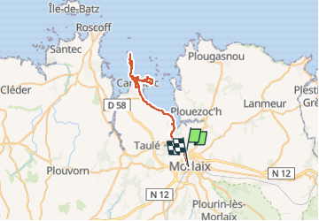
Tour Radtourismus von 41 km verfügbar auf Bretagne, Finistère, Morlaix. Diese Tour wird von ilur56 vorgeschlagen.
Beschreibung
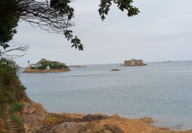
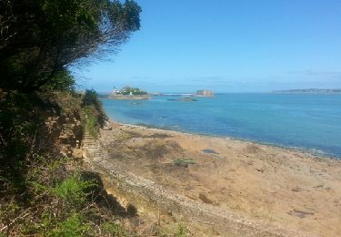
A vélo de Morlaix à Carantec puis à pied sur l'île Callot et de la Chaise du curé à l'arboretum puis à la chaise du curé et retour en vélo à Morlaix
Ort
Land:
France
Region :
Bretagne
Abteilung/Provinz :
Finistère
Kommune :
Morlaix
Standort:
Unknown
Gehen Sie:(Dec)
Gehen Sie:(UTM)
438047 ; 5382454 (30U) N.
Kommentare
Touren in der Umgebung
![Tour Wandern Saint-Martin-des-Champs - 29.08.23 Morlaix -- Carantec - Photo](https://media.geolcdn.com/t/375/260/5e95973a-bb61-48e1-be26-0d4b7c63c8a3.jpg&format=jpg&maxdim=2)
![Wandern Wandern](https://static1.geolcdn.com/sitytour/trail-icons/101.png)
29.08.23 Morlaix -- Carantec
Wandern
Sehr schwierig
Saint-Martin-des-Champs,
Bretagne,
Finistère,
France
![](/images/other/stat-length.png)
22 km | 28 km-effort
6h 16min
![](https://static1.geolcdn.com/siteimages/upload/files/16400158638029165_repeat_loop_refresh_sync_direction_icon.png)
Nein
![Tour Wandern Saint-Martin-des-Champs - Bretagne Nord J4 De Morlaix à Plougasnou - Photo](https://media.geolcdn.com/t/375/260/bdefe06e-9a70-47b4-b168-78b835207a1c.jpg&format=jpg&maxdim=2)
![Wandern Wandern](https://static1.geolcdn.com/sitytour/trail-icons/101.png)
Bretagne Nord J4 De Morlaix à Plougasnou
Wandern
Medium
Saint-Martin-des-Champs,
Bretagne,
Finistère,
France
![](/images/other/stat-length.png)
25 km | 30 km-effort
5h 51min
![](https://static1.geolcdn.com/siteimages/upload/files/16400158638029165_repeat_loop_refresh_sync_direction_icon.png)
Nein
![Tour Wandern Morlaix - Bretagne nord J3 pm Visite de Morlaix - Photo](https://media.geolcdn.com/t/375/260/a5fc4049-6301-4d21-b592-65eec0e48eef.jpg&format=jpg&maxdim=2)
![Wandern Wandern](https://static1.geolcdn.com/sitytour/trail-icons/101.png)
Bretagne nord J3 pm Visite de Morlaix
Wandern
Sehr leicht
Morlaix,
Bretagne,
Finistère,
France
![](/images/other/stat-length.png)
6 km | 7,5 km-effort
2h 0min
![](https://static1.geolcdn.com/siteimages/upload/files/16400158638029165_repeat_loop_refresh_sync_direction_icon.png)
Nein
![Tour Zu Fuß Saint-Martin-des-Champs - Vallée de la Pennélé - Photo](https://media.geolcdn.com/t/375/260/2f6b944a-859b-4f33-ad39-6ae6504e269d.jpeg&format=jpg&maxdim=2)
![Zu Fuß Zu Fuß](https://static1.geolcdn.com/sitytour/trail-icons/100.png)
Vallée de la Pennélé
Zu Fuß
Einfach
Saint-Martin-des-Champs,
Bretagne,
Finistère,
France
![](/images/other/stat-length.png)
6,5 km | 7,9 km-effort
1h 48min
![](https://static1.geolcdn.com/siteimages/upload/files/16400158638029165_repeat_loop_refresh_sync_direction_icon.png)
Nein
![Tour Zu Fuß Locquénolé - Circuit du Phare de la Lande - Photo](https://media.geolcdn.com/t/375/260/f1f4f500-15ba-42ad-a100-c3242f454aa5.jpeg&format=jpg&maxdim=2)
![Zu Fuß Zu Fuß](https://static1.geolcdn.com/sitytour/trail-icons/100.png)
Circuit du Phare de la Lande
Zu Fuß
Einfach
Locquénolé,
Bretagne,
Finistère,
France
![](/images/other/stat-length.png)
7,9 km | 10,1 km-effort
2h 17min
![](https://static1.geolcdn.com/siteimages/upload/files/16400158638029165_repeat_loop_refresh_sync_direction_icon.png)
Ja
![Tour Zu Fuß Taulé - Circuit du Bois de Lannigou - Photo](https://media.geolcdn.com/t/375/260/f561f4b9-9280-45ba-ac9b-6ff7481177a4.jpeg&format=jpg&maxdim=2)
![Zu Fuß Zu Fuß](https://static1.geolcdn.com/sitytour/trail-icons/100.png)
Circuit du Bois de Lannigou
Zu Fuß
Einfach
Taulé,
Bretagne,
Finistère,
France
![](/images/other/stat-length.png)
3,1 km | 4,1 km-effort
55min
![](https://static1.geolcdn.com/siteimages/upload/files/16400158638029165_repeat_loop_refresh_sync_direction_icon.png)
Ja
![Tour Wandern Saint-Martin-des-Champs - GR 34 étape 24 - Photo](https://media.geolcdn.com/t/375/260/ext.jpg?maxdim=2&url=https%3A%2F%2Fservices.sitytrail.com%2FGeolivesWS%2FDownloadMedia.ashx%3FTrailID%3D318891%26Media%3Dfix__20140514144043.jpg)
![Wandern Wandern](https://static1.geolcdn.com/sitytour/trail-icons/101.png)
GR 34 étape 24
Wandern
Einfach
Saint-Martin-des-Champs,
Bretagne,
Finistère,
France
![](/images/other/stat-length.png)
28 km | 36 km-effort
8h 32min
![](https://static1.geolcdn.com/siteimages/upload/files/16400158638029165_repeat_loop_refresh_sync_direction_icon.png)
Nein
![Tour Wandern Locquénolé - Autour de Locquénolé - Photo](https://media.geolcdn.com/t/375/260/ext.jpg?maxdim=2&url=https%3A%2F%2Fservices.sitytrail.com%2FGeolivesWS%2FDownloadMedia.ashx%3FTrailID%3D317648%26Media%3D16922_5.jpg)
![Wandern Wandern](https://static1.geolcdn.com/sitytour/trail-icons/101.png)
Autour de Locquénolé
Wandern
Einfach
Locquénolé,
Bretagne,
Finistère,
France
![](/images/other/stat-length.png)
8,5 km | 10,8 km-effort
2h 45min
![](https://static1.geolcdn.com/siteimages/upload/files/16400158638029165_repeat_loop_refresh_sync_direction_icon.png)
Ja
![Tour Wandern Morlaix - morlaix art urbain et venelles - Photo](https://media.geolcdn.com/t/375/260/1a694ed8-5d0d-45d6-8d7b-c7ebb83cb535.jpg&format=jpg&maxdim=2)
![Wandern Wandern](https://static1.geolcdn.com/sitytour/trail-icons/101.png)
morlaix art urbain et venelles
Wandern
Medium
Morlaix,
Bretagne,
Finistère,
France
![](/images/other/stat-length.png)
6,9 km | 8,4 km-effort
2h 21min
![](https://static1.geolcdn.com/siteimages/upload/files/16400158638029165_repeat_loop_refresh_sync_direction_icon.png)
Ja