![](/images/other/stat-length.png)
![Tour Versailles - parcours-versailles-mantes-edition-2019 (1) - Photo](https://media.geolcdn.com/t/1900/400/ext.pjpeg?maxdim=2&url=https%3A%2F%2Fsecurestorage.geolives.com%2Fsitytour%2Ftrail-bg%2Fdefault.jpg)
parcours-versailles-mantes-edition-2019 (1)
chessyca
Benutzer GUIDE
![Länge](/images/other/stat-length.png)
Länge
53 km
![Maximale Höhe](https://static1.geolcdn.com/siteimages/upload/files/1508320355ic_sort_altitude_max_24dp.png)
Maximale Höhe
192 m
![Positive Höhendifferenz](https://static1.geolcdn.com/siteimages/upload/files/1508320355ic_sort_den_pos_24dp.png)
Positive Höhendifferenz
538 m
![Km-Effort](/images/other/stat-length.png)
Km-Effort
60 km
![Min. Höhe](https://static1.geolcdn.com/siteimages/upload/files/1508320355ic_sort_altitude_min_24dp.png)
Min. Höhe
16 m
![Negative Höhendifferenz](https://static1.geolcdn.com/siteimages/upload/files/1508320355ic_sort_den_neg_24dp.png)
Negative Höhendifferenz
631 m
![Boucle](https://static1.geolcdn.com/siteimages/upload/files/16400158638029165_repeat_loop_refresh_sync_direction_icon.png)
Boucle
Nein
Erstellungsdatum :
2022-05-06 07:01:59.497
Letzte Änderung :
2022-05-06 07:01:59.497
![Scannen Sie diesen QR-Code, um die Tour in der SityTrail-Anwendung zu öffnen](https://capi.geolives.com/qq0zvz2zws4bq2lad0pu/sitytour/trails/3231423/qr.png?size=200)
Kostenlosegpshiking-Anwendung
Über SityTrail
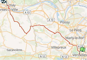
Tour von 53 km verfügbar auf Île-de-France, Yvelines, Versailles. Diese Tour wird von chessyca vorgeschlagen.
Beschreibung
Parcours de la 84ème édition de la mytique course du Versailles- Mante la Jolie
8 Participants Yerrois ( 5 en groupe / 3 en individuels)
Relive [url]https://youtu.be/NfVJ7y97HlI[/url]
Ort
Land:
France
Region :
Île-de-France
Abteilung/Provinz :
Yvelines
Kommune :
Versailles
Standort:
Unknown
Gehen Sie:(Dec)
Gehen Sie:(UTM)
435781 ; 5406021 (31U) N.
Kommentare
Touren in der Umgebung
![Tour Wandern Jouy-en-Josas - GRP CV-IDF 2023 - Photo](https://media.geolcdn.com/t/375/260/0b37f40c-1685-409c-9ec1-27f69abf4580.jpg&format=jpg&maxdim=2)
![Wandern Wandern](https://static1.geolcdn.com/sitytour/trail-icons/101.png)
GRP CV-IDF 2023
Wandern
Schwierig
(1)
Jouy-en-Josas,
Île-de-France,
Yvelines,
France
![](/images/other/stat-length.png)
11,2 km | 14,5 km-effort
3h 17min
![](https://static1.geolcdn.com/siteimages/upload/files/16400158638029165_repeat_loop_refresh_sync_direction_icon.png)
Nein
![Tour Wandern Viroflay - Les 3 Forêts; Meudon, Fausses Reposes et Versailles - Photo](https://media.geolcdn.com/t/375/260/ext.jpg?maxdim=2&url=https%3A%2F%2Fservices.sitytrail.com%2FGeolivesWS%2FDownloadMedia.ashx%3FTrailID%3D110157%26Media%3D5357_1.jpg)
![Wandern Wandern](https://static1.geolcdn.com/sitytour/trail-icons/101.png)
Les 3 Forêts; Meudon, Fausses Reposes et Versailles
Wandern
Schwierig
(2)
Viroflay,
Île-de-France,
Yvelines,
France
![](/images/other/stat-length.png)
25 km | 32 km-effort
5h 19min
![](https://static1.geolcdn.com/siteimages/upload/files/16400158638029165_repeat_loop_refresh_sync_direction_icon.png)
Ja
![Tour Wandern Buc - Le Tour de Satory - Photo](https://media.geolcdn.com/t/375/260/ext.jpg?maxdim=2&url=https%3A%2F%2Fservices.sitytrail.com%2FGeolivesWS%2FDownloadMedia.ashx%3FTrailID%3D110070%26Media%3D5206_1.jpg)
![Wandern Wandern](https://static1.geolcdn.com/sitytour/trail-icons/101.png)
Le Tour de Satory
Wandern
Schwierig
(2)
Buc,
Île-de-France,
Yvelines,
France
![](/images/other/stat-length.png)
23 km | 28 km-effort
4h 49min
![](https://static1.geolcdn.com/siteimages/upload/files/16400158638029165_repeat_loop_refresh_sync_direction_icon.png)
Ja
![Tour Wandern Versailles - 20240828_100557 - Photo](https://media.geolcdn.com/t/375/260/0408d080-39aa-4237-87eb-b73399a86f56.jpg&format=jpg&maxdim=2)
![Wandern Wandern](https://static1.geolcdn.com/sitytour/trail-icons/101.png)
20240828_100557
Wandern
Sehr schwierig
Versailles,
Île-de-France,
Yvelines,
France
![](/images/other/stat-length.png)
19,7 km | 25 km-effort
5h 34min
![](https://static1.geolcdn.com/siteimages/upload/files/16400158638029165_repeat_loop_refresh_sync_direction_icon.png)
Ja
![Tour Zu Fuß Versailles - Boucle 28 km autour de Versailles - Photo](https://media.geolcdn.com/t/375/260/94e41505-1074-4e90-9565-89ecf7d9db7c.jpg&format=jpg&maxdim=2)
![Zu Fuß Zu Fuß](https://static1.geolcdn.com/sitytour/trail-icons/100.png)
Boucle 28 km autour de Versailles
Zu Fuß
Medium
Versailles,
Île-de-France,
Yvelines,
France
![](/images/other/stat-length.png)
28 km | 33 km-effort
7h 25min
![](https://static1.geolcdn.com/siteimages/upload/files/16400158638029165_repeat_loop_refresh_sync_direction_icon.png)
Ja
![Tour Zu Fuß Versailles - Boucle autour de Versailles - Photo](https://media.geolcdn.com/t/375/260/6e4f8acc-fcc0-4dbb-b81f-7def4b7ae38d.jpg&format=jpg&maxdim=2)
![Zu Fuß Zu Fuß](https://static1.geolcdn.com/sitytour/trail-icons/100.png)
Boucle autour de Versailles
Zu Fuß
Sehr leicht
Versailles,
Île-de-France,
Yvelines,
France
![](/images/other/stat-length.png)
22 km | 26 km-effort
5h 49min
![](https://static1.geolcdn.com/siteimages/upload/files/16400158638029165_repeat_loop_refresh_sync_direction_icon.png)
Ja
![Tour Wandern Guyancourt - ALBG Etang val d'or, minière - Photo](https://media.geolcdn.com/t/375/260/ext.jpg?maxdim=2&url=https%3A%2F%2Fstatic1.geolcdn.com%2Fsiteimages%2Fupload%2Ffiles%2F1553511878bg_sport_marche.png)
![Wandern Wandern](https://static1.geolcdn.com/sitytour/trail-icons/101.png)
ALBG Etang val d'or, minière
Wandern
Einfach
(1)
Guyancourt,
Île-de-France,
Yvelines,
France
![](/images/other/stat-length.png)
13,1 km | 16,1 km-effort
3h 41min
![](https://static1.geolcdn.com/siteimages/upload/files/16400158638029165_repeat_loop_refresh_sync_direction_icon.png)
Ja
![Tour Andere Aktivitäten Versailles - Parc de Versailles - Photo](https://media.geolcdn.com/t/375/260/ext.jpg?maxdim=2&url=https%3A%2F%2Fstatic1.geolcdn.com%2Fsiteimages%2Fupload%2Ffiles%2F1545311037marcheuse_200dpi.jpg)
![Andere Aktivitäten Andere Aktivitäten](https://static1.geolcdn.com/sitytour/trail-icons/900.png)
Parc de Versailles
Andere Aktivitäten
Sehr leicht
(1)
Versailles,
Île-de-France,
Yvelines,
France
![](/images/other/stat-length.png)
8,9 km | 9,7 km-effort
1h 49min
![](https://static1.geolcdn.com/siteimages/upload/files/16400158638029165_repeat_loop_refresh_sync_direction_icon.png)
Ja
![Tour Mountainbike Saint-Cyr-l'École - 14102013 - Photo](https://media.geolcdn.com/t/375/260/ext.jpg?maxdim=2&url=https%3A%2F%2Fstatic1.geolcdn.com%2Fsiteimages%2Fupload%2Ffiles%2F1524743154velo.jpg)
![Mountainbike Mountainbike](https://static1.geolcdn.com/sitytour/trail-icons/202.png)
14102013
Mountainbike
Medium
(1)
Saint-Cyr-l'École,
Île-de-France,
Yvelines,
France
![](/images/other/stat-length.png)
42 km | 50 km-effort
3h 11min
![](https://static1.geolcdn.com/siteimages/upload/files/16400158638029165_repeat_loop_refresh_sync_direction_icon.png)
Ja