![](/images/other/stat-length.png)
![Tour Wandern Allègre-les-Fumades - Les Aiguières - Photo](https://media.geolcdn.com/t/1900/400/ext.pjpeg?maxdim=2&url=https%3A%2F%2Fstatic1.geolcdn.com%2Fsiteimages%2Fupload%2Ffiles%2F1553511878bg_sport_marche.png)
Les Aiguières
JMJ42
Benutzer
![Länge](/images/other/stat-length.png)
Länge
12,4 km
![Maximale Höhe](https://static1.geolcdn.com/siteimages/upload/files/1508320355ic_sort_altitude_max_24dp.png)
Maximale Höhe
314 m
![Positive Höhendifferenz](https://static1.geolcdn.com/siteimages/upload/files/1508320355ic_sort_den_pos_24dp.png)
Positive Höhendifferenz
262 m
![Km-Effort](/images/other/stat-length.png)
Km-Effort
15,9 km
![Min. Höhe](https://static1.geolcdn.com/siteimages/upload/files/1508320355ic_sort_altitude_min_24dp.png)
Min. Höhe
126 m
![Negative Höhendifferenz](https://static1.geolcdn.com/siteimages/upload/files/1508320355ic_sort_den_neg_24dp.png)
Negative Höhendifferenz
262 m
![Boucle](https://static1.geolcdn.com/siteimages/upload/files/16400158638029165_repeat_loop_refresh_sync_direction_icon.png)
Boucle
Ja
Erstellungsdatum :
2022-05-03 16:29:54.658
Letzte Änderung :
2022-05-03 16:34:02.626
![Wandern](https://static1.geolcdn.com/sitytour/trail-icons/101.png)
3h37
Schwierigkeit : Schwierig
![Scannen Sie diesen QR-Code, um die Tour in der SityTrail-Anwendung zu öffnen](https://capi.geolives.com/qq0zvz2zws4bq2lad0pu/sitytour/trails/3228330/qr.png?size=200)
Kostenlosegpshiking-Anwendung
Über SityTrail
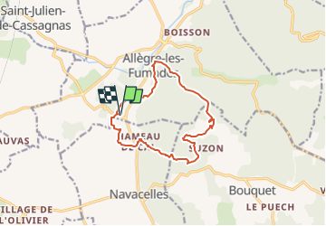
Tour Wandern von 12,4 km verfügbar auf Okzitanien, Gard, Allègre-les-Fumades. Diese Tour wird von JMJ42 vorgeschlagen.
Beschreibung
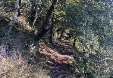
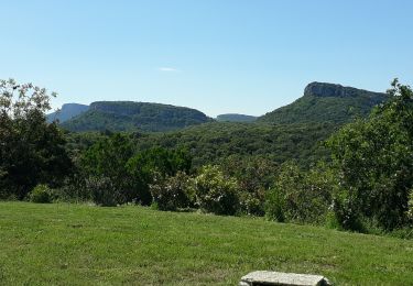
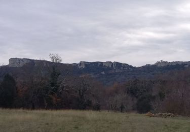
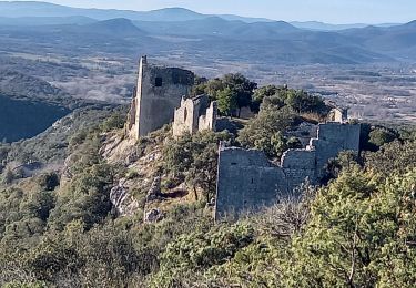
Très beau points de vue, un peu de DFCI et de goudron mais largement compensés par les Aiguières.
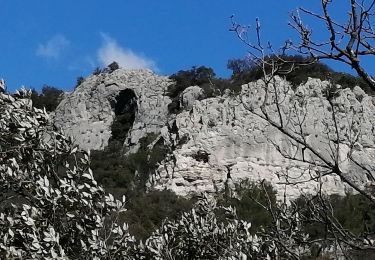
Descente dans le valat de Séguissous un peu difficile.
Ort
Land:
France
Region :
Okzitanien
Abteilung/Provinz :
Gard
Kommune :
Allègre-les-Fumades
Standort:
Unknown
Gehen Sie:(Dec)
Gehen Sie:(UTM)
598494 ; 4893151 (31T) N.
Kommentare
Touren in der Umgebung
![Tour Wandern Navacelles - Les Aiguiéres au départ de Call - Photo](https://media.geolcdn.com/t/375/260/ceda67ec-d101-468c-8a83-e91809d135cb.jpg&format=jpg&maxdim=2)
![Wandern Wandern](https://static1.geolcdn.com/sitytour/trail-icons/101.png)
Les Aiguiéres au départ de Call
Wandern
Schwierig
(1)
Navacelles,
Okzitanien,
Gard,
France
![](/images/other/stat-length.png)
10,4 km | 14,9 km-effort
4h 39min
![](https://static1.geolcdn.com/siteimages/upload/files/16400158638029165_repeat_loop_refresh_sync_direction_icon.png)
Ja
![Tour Wandern Allègre-les-Fumades - château d allègre aiguieres - Photo](https://media.geolcdn.com/t/375/260/c7f87895-b1c3-467b-937c-ecf963f10da2.jpg&format=jpg&maxdim=2)
![Wandern Wandern](https://static1.geolcdn.com/sitytour/trail-icons/101.png)
château d allègre aiguieres
Wandern
Medium
(1)
Allègre-les-Fumades,
Okzitanien,
Gard,
France
![](/images/other/stat-length.png)
16,9 km | 25 km-effort
6h 10min
![](https://static1.geolcdn.com/siteimages/upload/files/16400158638029165_repeat_loop_refresh_sync_direction_icon.png)
Ja
![Tour Wandern Navacelles - Aiguieres par Cal - Photo](https://media.geolcdn.com/t/375/260/ext.jpg?maxdim=2&url=https%3A%2F%2Fservices.sitytrail.com%2FGeolivesWS%2FDownloadMedia.ashx%3FTrailID%3D406963%26Media%3Dfix__20150412123451.jpg)
![Wandern Wandern](https://static1.geolcdn.com/sitytour/trail-icons/101.png)
Aiguieres par Cal
Wandern
Medium
(2)
Navacelles,
Okzitanien,
Gard,
France
![](/images/other/stat-length.png)
8,9 km | 12,6 km-effort
2h 20min
![](https://static1.geolcdn.com/siteimages/upload/files/16400158638029165_repeat_loop_refresh_sync_direction_icon.png)
Ja
![Tour Wandern Navacelles - Château d'Allegre / Aiguières - Photo](https://media.geolcdn.com/t/375/260/3f553ed7-1a33-4856-a98a-164e5181c4df.jpg&format=jpg&maxdim=2)
![Wandern Wandern](https://static1.geolcdn.com/sitytour/trail-icons/101.png)
Château d'Allegre / Aiguières
Wandern
Schwierig
Navacelles,
Okzitanien,
Gard,
France
![](/images/other/stat-length.png)
20 km | 29 km-effort
7h 18min
![](https://static1.geolcdn.com/siteimages/upload/files/16400158638029165_repeat_loop_refresh_sync_direction_icon.png)
Ja
![Tour Wandern Rivières - 231203_Rivières - Photo](https://media.geolcdn.com/t/375/260/90c703ff-22cb-4a53-ba01-e199fc09b073.jpg&format=jpg&maxdim=2)
![Wandern Wandern](https://static1.geolcdn.com/sitytour/trail-icons/101.png)
231203_Rivières
Wandern
Schwierig
Rivières,
Okzitanien,
Gard,
France
![](/images/other/stat-length.png)
15,4 km | 18,9 km-effort
5h 43min
![](https://static1.geolcdn.com/siteimages/upload/files/16400158638029165_repeat_loop_refresh_sync_direction_icon.png)
Ja
![Tour Elektrofahrrad Rousson - Tour du Mont-Bouquet - Photo](https://media.geolcdn.com/t/375/260/6cb0bff4-b846-4486-8ff2-e6201a86b912.jpeg&format=jpg&maxdim=2)
![Elektrofahrrad Elektrofahrrad](https://static1.geolcdn.com/sitytour/trail-icons/205.png)
Tour du Mont-Bouquet
Elektrofahrrad
Medium
Rousson,
Okzitanien,
Gard,
France
![](/images/other/stat-length.png)
28 km | 34 km-effort
1h 25min
![](https://static1.geolcdn.com/siteimages/upload/files/16400158638029165_repeat_loop_refresh_sync_direction_icon.png)
Ja
![Tour Wandern Bouquet - Mont Bouquet au départ de Bouquet - Photo](https://media.geolcdn.com/t/375/260/a613b6df-45f0-4c8c-a8d8-8341a508f2f6.jpg&format=jpg&maxdim=2)
![Wandern Wandern](https://static1.geolcdn.com/sitytour/trail-icons/101.png)
Mont Bouquet au départ de Bouquet
Wandern
Schwierig
Bouquet,
Okzitanien,
Gard,
France
![](/images/other/stat-length.png)
17 km | 26 km-effort
5h 11min
![](https://static1.geolcdn.com/siteimages/upload/files/16400158638029165_repeat_loop_refresh_sync_direction_icon.png)
Ja
![Wandern Wandern](https://static1.geolcdn.com/sitytour/trail-icons/101.png)
Argensol, chapelle St Saturnin, Château d'Alègre
Wandern
Schwierig
Allègre-les-Fumades,
Okzitanien,
Gard,
France
![](/images/other/stat-length.png)
8,7 km | 12,1 km-effort
2h 44min
![](https://static1.geolcdn.com/siteimages/upload/files/16400158638029165_repeat_loop_refresh_sync_direction_icon.png)
Ja
![Tour Wandern Allègre-les-Fumades - Chateau d'Allegre par les crêtes et défilé d'Argensol - Photo](https://media.geolcdn.com/t/375/260/cf4de307-4e0a-401c-8a29-7a796fd485c8.jpg&format=jpg&maxdim=2)
![Wandern Wandern](https://static1.geolcdn.com/sitytour/trail-icons/101.png)
Chateau d'Allegre par les crêtes et défilé d'Argensol
Wandern
Medium
Allègre-les-Fumades,
Okzitanien,
Gard,
France
![](/images/other/stat-length.png)
9,5 km | 13 km-effort
3h 42min
![](https://static1.geolcdn.com/siteimages/upload/files/16400158638029165_repeat_loop_refresh_sync_direction_icon.png)
Ja
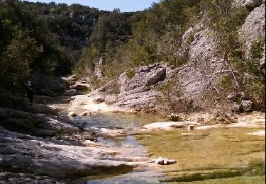
La randonnée est plutôt sympa. Un peu difficile avant d'arrivés aux Aiguières puisque que le chemins est escarpé avec des cailloux, mais une fois en bas le spot est très jolie, même si la rivière manquée un peu d'eau.