![](/images/other/stat-length.png)
![Tour Wandern Durbuy - Rideux-Erezée-Rideux - Photo](https://media.geolcdn.com/t/1900/400/ext.pjpeg?maxdim=2&url=https%3A%2F%2Fstatic1.geolcdn.com%2Fsiteimages%2Fupload%2Ffiles%2F1553511878bg_sport_marche.png)
Rideux-Erezée-Rideux
mordant.ben@gmail.com
Benutzer
![Länge](/images/other/stat-length.png)
Länge
20 km
![Maximale Höhe](https://static1.geolcdn.com/siteimages/upload/files/1508320355ic_sort_altitude_max_24dp.png)
Maximale Höhe
401 m
![Positive Höhendifferenz](https://static1.geolcdn.com/siteimages/upload/files/1508320355ic_sort_den_pos_24dp.png)
Positive Höhendifferenz
534 m
![Km-Effort](/images/other/stat-length.png)
Km-Effort
27 km
![Min. Höhe](https://static1.geolcdn.com/siteimages/upload/files/1508320355ic_sort_altitude_min_24dp.png)
Min. Höhe
213 m
![Negative Höhendifferenz](https://static1.geolcdn.com/siteimages/upload/files/1508320355ic_sort_den_neg_24dp.png)
Negative Höhendifferenz
534 m
![Boucle](https://static1.geolcdn.com/siteimages/upload/files/16400158638029165_repeat_loop_refresh_sync_direction_icon.png)
Boucle
Ja
Erstellungsdatum :
2014-12-10 00:00:00.0
Letzte Änderung :
2020-09-19 14:17:16.296
![Wandern](https://static1.geolcdn.com/sitytour/trail-icons/101.png)
5h45
Schwierigkeit : Sehr schwierig
![Scannen Sie diesen QR-Code, um die Tour in der SityTrail-Anwendung zu öffnen](https://capi.geolives.com/qq0zvz2zws4bq2lad0pu/sitytour/trails/322344/qr.png?size=200)
Kostenlosegpshiking-Anwendung
Über SityTrail
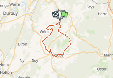
Tour Wandern von 20 km verfügbar auf Wallonien, Luxemburg, Durbuy. Diese Tour wird von mordant.ben@gmail.com vorgeschlagen.
Beschreibung
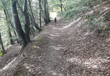
Voilà une randonnée avec un minimum de macadam et la possibilité de faire une halte dans un café d'Erezée....
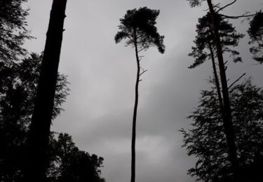
Ce n'est pas plat, on n'est pas à la mer.
20kms pile
Ort
Land:
Belgium
Region :
Wallonien
Abteilung/Provinz :
Luxemburg
Kommune :
Durbuy
Standort:
Heyd
Gehen Sie:(Dec)
Gehen Sie:(UTM)
682524 ; 5579652 (31U) N.
Kommentare
Touren in der Umgebung
![Tour Wandern Érezée - Hoursinne. Natura 2000, des sites qui valent le détour. Lx 1 - Photo](https://media.geolcdn.com/t/375/260/ext.jpg?maxdim=2&url=https%3A%2F%2Fservices.sitytrail.com%2FGeolivesWS%2FDownloadMedia.ashx%3FTrailID%3D142589%26Media%3Df0338fc2-a78f-45f3-92a6-ccf3ccce12cc.JPG)
![Wandern Wandern](https://static1.geolcdn.com/sitytour/trail-icons/101.png)
Hoursinne. Natura 2000, des sites qui valent le détour. Lx 1
Wandern
Schwierig
(9)
Érezée,
Wallonien,
Luxemburg,
Belgium
![](/images/other/stat-length.png)
8,1 km | 10,8 km-effort
2h 19min
![](https://static1.geolcdn.com/siteimages/upload/files/16400158638029165_repeat_loop_refresh_sync_direction_icon.png)
Ja
![Tour Wandern Durbuy - RF-Lu-01 - De dolmens en menhirs autour de Wéris - Photo](https://media.geolcdn.com/t/375/260/ext.jpg?maxdim=2&url=https%3A%2F%2Fstatic1.geolcdn.com%2Fsiteimages%2Fupload%2Ffiles%2F1553511878bg_sport_marche.png)
![Wandern Wandern](https://static1.geolcdn.com/sitytour/trail-icons/101.png)
RF-Lu-01 - De dolmens en menhirs autour de Wéris
Wandern
Sehr leicht
(7)
Durbuy,
Wallonien,
Luxemburg,
Belgium
![](/images/other/stat-length.png)
12,7 km | 16,5 km-effort
3h 32min
![](https://static1.geolcdn.com/siteimages/upload/files/16400158638029165_repeat_loop_refresh_sync_direction_icon.png)
Ja
![Tour Wandern Érezée - 2024-10-14_11h35m13_IntincheraEreze - Photo](https://media.geolcdn.com/t/375/260/cc06b86b-a86f-40a6-b741-b1d0842ad353.jpg&format=jpg&maxdim=2)
![Wandern Wandern](https://static1.geolcdn.com/sitytour/trail-icons/101.png)
2024-10-14_11h35m13_IntincheraEreze
Wandern
Medium
(1)
Érezée,
Wallonien,
Luxemburg,
Belgium
![](/images/other/stat-length.png)
10,6 km | 14,5 km-effort
3h 18min
![](https://static1.geolcdn.com/siteimages/upload/files/16400158638029165_repeat_loop_refresh_sync_direction_icon.png)
Ja
![Tour Wandern Durbuy - Balade à Bomal sur Ourthe - Photo](https://media.geolcdn.com/t/375/260/5741dd62-7ff1-40d2-b9aa-0e0aed97da9a.jpg&format=jpg&maxdim=2)
![Wandern Wandern](https://static1.geolcdn.com/sitytour/trail-icons/101.png)
Balade à Bomal sur Ourthe
Wandern
Einfach
(4)
Durbuy,
Wallonien,
Luxemburg,
Belgium
![](/images/other/stat-length.png)
4,4 km | 5,9 km-effort
1h 20min
![](https://static1.geolcdn.com/siteimages/upload/files/16400158638029165_repeat_loop_refresh_sync_direction_icon.png)
Ja
![Tour Wandern Manhay - 2021-06-30_10h29m50_Cirkwi-BOIS_DE_HARRE_(Commune_de_MANHAY) - Photo](https://media.geolcdn.com/t/375/260/c09deda8-fc97-4a3a-abcd-a27b1902d3a9.jpg&format=jpg&maxdim=2)
![Wandern Wandern](https://static1.geolcdn.com/sitytour/trail-icons/101.png)
2021-06-30_10h29m50_Cirkwi-BOIS_DE_HARRE_(Commune_de_MANHAY)
Wandern
Medium
(1)
Manhay,
Wallonien,
Luxemburg,
Belgium
![](/images/other/stat-length.png)
13,5 km | 18,9 km-effort
4h 17min
![](https://static1.geolcdn.com/siteimages/upload/files/16400158638029165_repeat_loop_refresh_sync_direction_icon.png)
Ja
![Wandern Wandern](https://static1.geolcdn.com/sitytour/trail-icons/101.png)
GG2-Lu-36_Bomal-Marloie (2021-11-04)
Wandern
Medium
(2)
Durbuy,
Wallonien,
Luxemburg,
Belgium
![](/images/other/stat-length.png)
43 km | 52 km-effort
11h 51min
![](https://static1.geolcdn.com/siteimages/upload/files/16400158638029165_repeat_loop_refresh_sync_direction_icon.png)
Nein
![Tour Wandern Durbuy - entre le menhir Pire Hena et le dolmen de Weris ... wouai... - Photo](https://media.geolcdn.com/t/375/260/55715ad5-9df7-48ff-88d3-eb1d3370cd88.jpg&format=jpg&maxdim=2)
![Wandern Wandern](https://static1.geolcdn.com/sitytour/trail-icons/101.png)
entre le menhir Pire Hena et le dolmen de Weris ... wouai...
Wandern
Sehr leicht
(1)
Durbuy,
Wallonien,
Luxemburg,
Belgium
![](/images/other/stat-length.png)
6 km | 7,9 km-effort
2h 0min
![](https://static1.geolcdn.com/siteimages/upload/files/16400158638029165_repeat_loop_refresh_sync_direction_icon.png)
Ja
![Tour Wandern Durbuy - Deux boucles du Rideux-20kms - Photo](https://media.geolcdn.com/t/375/260/0f5f5c48-cbf4-49e1-bd2e-2bdc08093db1.jpg&format=jpg&maxdim=2)
![Wandern Wandern](https://static1.geolcdn.com/sitytour/trail-icons/101.png)
Deux boucles du Rideux-20kms
Wandern
Sehr schwierig
(1)
Durbuy,
Wallonien,
Luxemburg,
Belgium
![](/images/other/stat-length.png)
21 km | 28 km-effort
5h 54min
![](https://static1.geolcdn.com/siteimages/upload/files/16400158638029165_repeat_loop_refresh_sync_direction_icon.png)
Ja
![Tour Wandern Érezée - Papillon de Fanzel-12 - Photo](https://media.geolcdn.com/t/375/260/f829c3de-70a8-4bc7-954f-0855257a9e97.jpg&format=jpg&maxdim=2)
![Wandern Wandern](https://static1.geolcdn.com/sitytour/trail-icons/101.png)
Papillon de Fanzel-12
Wandern
Schwierig
(1)
Érezée,
Wallonien,
Luxemburg,
Belgium
![](/images/other/stat-length.png)
11,9 km | 17,5 km-effort
3h 39min
![](https://static1.geolcdn.com/siteimages/upload/files/16400158638029165_repeat_loop_refresh_sync_direction_icon.png)
Ja