![](/images/other/stat-length.png)
![Tour Wandern Ramonchamp - Ramonchamp 06.07.14 - Photo](https://media.geolcdn.com/t/1900/400/ext.pjpeg?maxdim=2&url=https%3A%2F%2Fstatic1.geolcdn.com%2Fsiteimages%2Fupload%2Ffiles%2F1553511878bg_sport_marche.png)
Ramonchamp 06.07.14
joelclaudel
Benutzer
![Länge](/images/other/stat-length.png)
Länge
10,3 km
![Maximale Höhe](https://static1.geolcdn.com/siteimages/upload/files/1508320355ic_sort_altitude_max_24dp.png)
Maximale Höhe
623 m
![Positive Höhendifferenz](https://static1.geolcdn.com/siteimages/upload/files/1508320355ic_sort_den_pos_24dp.png)
Positive Höhendifferenz
283 m
![Km-Effort](/images/other/stat-length.png)
Km-Effort
14,1 km
![Min. Höhe](https://static1.geolcdn.com/siteimages/upload/files/1508320355ic_sort_altitude_min_24dp.png)
Min. Höhe
463 m
![Negative Höhendifferenz](https://static1.geolcdn.com/siteimages/upload/files/1508320355ic_sort_den_neg_24dp.png)
Negative Höhendifferenz
283 m
![Boucle](https://static1.geolcdn.com/siteimages/upload/files/16400158638029165_repeat_loop_refresh_sync_direction_icon.png)
Boucle
Ja
Erstellungsdatum :
2014-12-10 00:00:00.0
Letzte Änderung :
2014-12-10 00:00:00.0
![Wandern](https://static1.geolcdn.com/sitytour/trail-icons/101.png)
3h03
Schwierigkeit : Einfach
![Scannen Sie diesen QR-Code, um die Tour in der SityTrail-Anwendung zu öffnen](https://capi.geolives.com/qq0zvz2zws4bq2lad0pu/sitytour/trails/321726/qr.png?size=200)
Kostenlosegpshiking-Anwendung
Über SityTrail
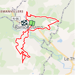
Tour Wandern von 10,3 km verfügbar auf Großer Osten, Vogesen, Ramonchamp. Diese Tour wird von joelclaudel vorgeschlagen.
Beschreibung
Circuit en "huit" au départ du parking de la salle des Fêtes de Ramonchamp.
La filature, la Ravanne, Grammont,retour centre du village, l'Etraye, la Roche Joly, sentier botanique et retour parking.
Ort
Land:
France
Region :
Großer Osten
Abteilung/Provinz :
Vogesen
Kommune :
Ramonchamp
Standort:
Unknown
Gehen Sie:(Dec)
Gehen Sie:(UTM)
330998 ; 5306809 (32T) N.
Kommentare
Touren in der Umgebung
![Tour Wandern Le Ménil - Boucle au départ des chalets de la](https://media.geolcdn.com/t/375/260/a828a9f3-0482-4d5b-86c2-c919e4b59d9f.jpg&format=jpg&maxdim=2)
![Wandern Wandern](https://static1.geolcdn.com/sitytour/trail-icons/101.png)
Boucle au départ des chalets de la "Vosges Attitude"
Wandern
Einfach
(3)
Le Ménil,
Großer Osten,
Vogesen,
France
![](/images/other/stat-length.png)
10 km | 14,1 km-effort
3h 0min
![](https://static1.geolcdn.com/siteimages/upload/files/16400158638029165_repeat_loop_refresh_sync_direction_icon.png)
Ja
![Tour Wandern Beulotte-Saint-Laurent - Randonnée des étangs - Beulotte Saint Laurent - Photo](https://media.geolcdn.com/t/375/260/ext.jpg?maxdim=2&url=https%3A%2F%2Fservices.sitytrail.com%2FGeolivesWS%2FDownloadMedia.ashx%3FTrailID%3D107231%26Media%3D12098_5.jpg)
![Wandern Wandern](https://static1.geolcdn.com/sitytour/trail-icons/101.png)
Randonnée des étangs - Beulotte Saint Laurent
Wandern
Medium
(4)
Beulotte-Saint-Laurent,
Burgund und Freigrafschaft,
Haute-Saône,
France
![](/images/other/stat-length.png)
10,7 km | 13,9 km-effort
2h 30min
![](https://static1.geolcdn.com/siteimages/upload/files/16400158638029165_repeat_loop_refresh_sync_direction_icon.png)
Ja
![Tour Zu Fuß Fresse-sur-Moselle - Les ballons à l’horizon - Photo](https://media.geolcdn.com/t/375/260/30df9189-1183-47e3-a585-be073639a450.jpeg&format=jpg&maxdim=2)
![Zu Fuß Zu Fuß](https://static1.geolcdn.com/sitytour/trail-icons/100.png)
Les ballons à l’horizon
Zu Fuß
Einfach
Fresse-sur-Moselle,
Großer Osten,
Vogesen,
France
![](/images/other/stat-length.png)
7,7 km | 12,6 km-effort
2h 51min
![](https://static1.geolcdn.com/siteimages/upload/files/16400158638029165_repeat_loop_refresh_sync_direction_icon.png)
Ja
![Tour Wandern Beulotte-Saint-Laurent - Beulotte-Saint-Laurent 13 700m + 317m - Photo](https://media.geolcdn.com/t/375/260/ext.jpg?maxdim=2&url=https%3A%2F%2Fstatic1.geolcdn.com%2Fsiteimages%2Fupload%2Ffiles%2F1553511878bg_sport_marche.png)
![Wandern Wandern](https://static1.geolcdn.com/sitytour/trail-icons/101.png)
Beulotte-Saint-Laurent 13 700m + 317m
Wandern
Einfach
(1)
Beulotte-Saint-Laurent,
Burgund und Freigrafschaft,
Haute-Saône,
France
![](/images/other/stat-length.png)
13,7 km | 17,9 km-effort
3h 50min
![](https://static1.geolcdn.com/siteimages/upload/files/16400158638029165_repeat_loop_refresh_sync_direction_icon.png)
Ja
![Tour Wandern Haut-du-Them-Château-Lambert - Chateau-Lambert mines de cuivre et source de l'Oignon - Photo](https://media.geolcdn.com/t/375/260/ext.jpg?maxdim=2&url=https%3A%2F%2Fstatic1.geolcdn.com%2Fsiteimages%2Fupload%2Ffiles%2F1553511878bg_sport_marche.png)
![Wandern Wandern](https://static1.geolcdn.com/sitytour/trail-icons/101.png)
Chateau-Lambert mines de cuivre et source de l'Oignon
Wandern
Einfach
(1)
Haut-du-Them-Château-Lambert,
Burgund und Freigrafschaft,
Haute-Saône,
France
![](/images/other/stat-length.png)
9,6 km | 14,6 km-effort
2h 30min
![](https://static1.geolcdn.com/siteimages/upload/files/16400158638029165_repeat_loop_refresh_sync_direction_icon.png)
Ja
![Tour Wandern Ramonchamp - Tournée de 3 chalets - Photo](https://media.geolcdn.com/t/375/260/9772d619-fbbf-4858-9b6a-d813a318e1c1.jpeg&format=jpg&maxdim=2)
![Wandern Wandern](https://static1.geolcdn.com/sitytour/trail-icons/101.png)
Tournée de 3 chalets
Wandern
Medium
Ramonchamp,
Großer Osten,
Vogesen,
France
![](/images/other/stat-length.png)
6,2 km | 9 km-effort
2h 3min
![](https://static1.geolcdn.com/siteimages/upload/files/16400158638029165_repeat_loop_refresh_sync_direction_icon.png)
Ja
![Tour Wandern Fresse-sur-Moselle - Croix de Fresse - Vosges - France - Photo](https://media.geolcdn.com/t/375/260/1bf27e15-8257-4a1e-ac29-4caf5b1917b2.jpg&format=jpg&maxdim=2)
![Wandern Wandern](https://static1.geolcdn.com/sitytour/trail-icons/101.png)
Croix de Fresse - Vosges - France
Wandern
Medium
(1)
Fresse-sur-Moselle,
Großer Osten,
Vogesen,
France
![](/images/other/stat-length.png)
13,4 km | 19,6 km-effort
3h 10min
![](https://static1.geolcdn.com/siteimages/upload/files/16400158638029165_repeat_loop_refresh_sync_direction_icon.png)
Ja
![Tour Wandern Beulotte-Saint-Laurent - Beulotte St Laurent - le plateau des Mille Etangs - Photo](https://media.geolcdn.com/t/375/260/e526a3c8-361b-4678-a970-15d98b11e7c3.jpg&format=jpg&maxdim=2)
![Wandern Wandern](https://static1.geolcdn.com/sitytour/trail-icons/101.png)
Beulotte St Laurent - le plateau des Mille Etangs
Wandern
Schwierig
Beulotte-Saint-Laurent,
Burgund und Freigrafschaft,
Haute-Saône,
France
![](/images/other/stat-length.png)
22 km | 28 km-effort
4h 45min
![](https://static1.geolcdn.com/siteimages/upload/files/16400158638029165_repeat_loop_refresh_sync_direction_icon.png)
Ja
![Tour Wandern Le Thillot - Col des Croix - Vierge des Neiges - Hautes Mines - Tête des Noirs Étangs - Château Lambert - Photo](https://media.geolcdn.com/t/375/260/dd7bdea5-b733-4b98-94f9-1f87ee811abf.jpg&format=jpg&maxdim=2)
![Wandern Wandern](https://static1.geolcdn.com/sitytour/trail-icons/101.png)
Col des Croix - Vierge des Neiges - Hautes Mines - Tête des Noirs Étangs - Ch...
Wandern
Einfach
Le Thillot,
Großer Osten,
Vogesen,
France
![](/images/other/stat-length.png)
10,5 km | 16 km-effort
2h 23min
![](https://static1.geolcdn.com/siteimages/upload/files/16400158638029165_repeat_loop_refresh_sync_direction_icon.png)
Ja