![](/images/other/stat-length.png)
![Tour Wandern Aywaille - Balade de ninglinspo - Photo](https://media.geolcdn.com/t/1900/400/ext.pjpeg?maxdim=2&url=https%3A%2F%2Fstatic1.geolcdn.com%2Fsiteimages%2Fupload%2Ffiles%2F1553511878bg_sport_marche.png)
Balade de ninglinspo
Axelle Chevigné
Benutzer
![Länge](/images/other/stat-length.png)
Länge
6,3 km
![Maximale Höhe](https://static1.geolcdn.com/siteimages/upload/files/1508320355ic_sort_altitude_max_24dp.png)
Maximale Höhe
389 m
![Positive Höhendifferenz](https://static1.geolcdn.com/siteimages/upload/files/1508320355ic_sort_den_pos_24dp.png)
Positive Höhendifferenz
227 m
![Km-Effort](/images/other/stat-length.png)
Km-Effort
9,4 km
![Min. Höhe](https://static1.geolcdn.com/siteimages/upload/files/1508320355ic_sort_altitude_min_24dp.png)
Min. Höhe
161 m
![Negative Höhendifferenz](https://static1.geolcdn.com/siteimages/upload/files/1508320355ic_sort_den_neg_24dp.png)
Negative Höhendifferenz
226 m
![Boucle](https://static1.geolcdn.com/siteimages/upload/files/16400158638029165_repeat_loop_refresh_sync_direction_icon.png)
Boucle
Ja
Erstellungsdatum :
2022-04-24 12:48:44.0
Letzte Änderung :
2022-04-24 15:09:25.255
![Wandern](https://static1.geolcdn.com/sitytour/trail-icons/101.png)
1h54
Schwierigkeit : Medium
![Scannen Sie diesen QR-Code, um die Tour in der SityTrail-Anwendung zu öffnen](https://capi.geolives.com/qq0zvz2zws4bq2lad0pu/sitytour/trails/3216556/qr.png?size=200)
Kostenlosegpshiking-Anwendung
Über SityTrail
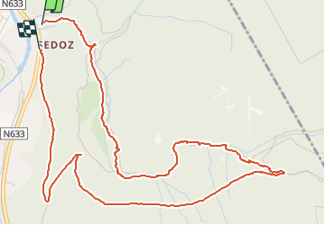
Tour Wandern von 6,3 km verfügbar auf Wallonien, Lüttich, Aywaille. Diese Tour wird von Axelle Chevigné vorgeschlagen.
Beschreibung
Chouette balade, nous avons commencé par la fin, beaucoup de montée assez sportif mais très cool a faire et la fin tout en descente (du coup c’est le début de la randonnée normalement)
Ort
Land:
Belgium
Region :
Wallonien
Abteilung/Provinz :
Lüttich
Kommune :
Aywaille
Standort:
Unknown
Gehen Sie:(Dec)
Gehen Sie:(UTM)
694728 ; 5594344 (31U) N.
Kommentare
Touren in der Umgebung
![Tour Wandern Theux - RB-Lg-24_La-Reid_via-racc-1 - Photo](https://media.geolcdn.com/t/375/260/ext.jpg?maxdim=2&url=https%3A%2F%2Fservices.sitytrail.com%2FGeolivesWS%2FDownloadMedia.ashx%3FTrailID%3D400924%26Media%3De46f0d15-4872-47d2-9c6f-9e812d51cefb.jpg)
![Wandern Wandern](https://static1.geolcdn.com/sitytour/trail-icons/101.png)
RB-Lg-24_La-Reid_via-racc-1
Wandern
(11)
Theux,
Wallonien,
Lüttich,
Belgium
![](/images/other/stat-length.png)
15,9 km | 21 km-effort
4h 50min
![](https://static1.geolcdn.com/siteimages/upload/files/16400158638029165_repeat_loop_refresh_sync_direction_icon.png)
Ja
![Tour Wandern Theux - RB-Lg-24_La-Reid - Photo](https://media.geolcdn.com/t/375/260/ext.jpg?maxdim=2&url=https%3A%2F%2Fservices.sitytrail.com%2FGeolivesWS%2FDownloadMedia.ashx%3FTrailID%3D400922%26Media%3De46f0d15-4872-47d2-9c6f-9e812d51cefb.jpg)
![Wandern Wandern](https://static1.geolcdn.com/sitytour/trail-icons/101.png)
![Tour Wandern Aywaille - RB-Lg-12 - De Sougné-Remouchamps à Deigné et retour - Photo](https://media.geolcdn.com/t/375/260/ext.jpg?maxdim=2&url=https%3A%2F%2Fservices.sitytrail.com%2FGeolivesWS%2FDownloadMedia.ashx%3FTrailID%3D179570%26Media%3D1074d230-2da3-49cf-8210-a5f6b46fd870.jpg)
![Wandern Wandern](https://static1.geolcdn.com/sitytour/trail-icons/101.png)
RB-Lg-12 - De Sougné-Remouchamps à Deigné et retour
Wandern
Schwierig
(9)
Aywaille,
Wallonien,
Lüttich,
Belgium
![](/images/other/stat-length.png)
24 km | 34 km-effort
7h 39min
![](https://static1.geolcdn.com/siteimages/upload/files/16400158638029165_repeat_loop_refresh_sync_direction_icon.png)
Ja
![Tour Wandern Aywaille - aywaille . florzé . martinrive . septroux . aywaille - Photo](https://media.geolcdn.com/t/375/260/8275975a-b8e8-47c1-9fb9-0580e1d080c9.jpg&format=jpg&maxdim=2)
![Wandern Wandern](https://static1.geolcdn.com/sitytour/trail-icons/101.png)
aywaille . florzé . martinrive . septroux . aywaille
Wandern
Einfach
(6)
Aywaille,
Wallonien,
Lüttich,
Belgium
![](/images/other/stat-length.png)
11,1 km | 15,4 km-effort
2h 48min
![](https://static1.geolcdn.com/siteimages/upload/files/16400158638029165_repeat_loop_refresh_sync_direction_icon.png)
Ja
![Tour Wandern Aywaille - Petite remontée du Ninglispo - Photo](https://media.geolcdn.com/t/375/260/ext.jpg?maxdim=2&url=https%3A%2F%2Fservices.sitytrail.com%2FGeolivesWS%2FDownloadMedia.ashx%3FTrailID%3D536482%26Media%3D20160311161707.jpg)
![Wandern Wandern](https://static1.geolcdn.com/sitytour/trail-icons/101.png)
Petite remontée du Ninglispo
Wandern
Medium
(9)
Aywaille,
Wallonien,
Lüttich,
Belgium
![](/images/other/stat-length.png)
6,7 km | 9,7 km-effort
2h 11min
![](https://static1.geolcdn.com/siteimages/upload/files/16400158638029165_repeat_loop_refresh_sync_direction_icon.png)
Ja
![Tour Wandern Aywaille - RB-LG-12 - Raccourci 2 - Photo](https://media.geolcdn.com/t/375/260/ext.jpg?maxdim=2&url=https%3A%2F%2Fservices.sitytrail.com%2FGeolivesWS%2FDownloadMedia.ashx%3FTrailID%3D209433%26Media%3D1f1ef83d-c0c7-4521-b15a-02c5e9e7c1f1.jpg)
![Wandern Wandern](https://static1.geolcdn.com/sitytour/trail-icons/101.png)
RB-LG-12 - Raccourci 2
Wandern
Schwierig
(6)
Aywaille,
Wallonien,
Lüttich,
Belgium
![](/images/other/stat-length.png)
17 km | 25 km-effort
5h 46min
![](https://static1.geolcdn.com/siteimages/upload/files/16400158638029165_repeat_loop_refresh_sync_direction_icon.png)
Ja
![Wandern Wandern](https://static1.geolcdn.com/sitytour/trail-icons/101.png)
20220717 - HUWAO La Reid - 7 Km
Wandern
Medium
(2)
Theux,
Wallonien,
Lüttich,
Belgium
![](/images/other/stat-length.png)
7 km | 9,5 km-effort
2h 34min
![](https://static1.geolcdn.com/siteimages/upload/files/16400158638029165_repeat_loop_refresh_sync_direction_icon.png)
Ja
![Tour Wandern Aywaille - 2021-04-23_12h03m48_1081 - Photo](https://media.geolcdn.com/t/375/260/fc604b5e-e950-4941-952b-ecd138cbf420.jpg&format=jpg&maxdim=2)
![Wandern Wandern](https://static1.geolcdn.com/sitytour/trail-icons/101.png)
2021-04-23_12h03m48_1081
Wandern
Medium
(1)
Aywaille,
Wallonien,
Lüttich,
Belgium
![](/images/other/stat-length.png)
17,3 km | 24 km-effort
5h 25min
![](https://static1.geolcdn.com/siteimages/upload/files/16400158638029165_repeat_loop_refresh_sync_direction_icon.png)
Ja
![Tour Wandern Aywaille - 2021-02-21_16h28m36_1382 - Photo](https://media.geolcdn.com/t/375/260/73151627-72a6-4506-ac77-59fc8213a179.jpg&format=jpg&maxdim=2)
![Wandern Wandern](https://static1.geolcdn.com/sitytour/trail-icons/101.png)
2021-02-21_16h28m36_1382
Wandern
Medium
(1)
Aywaille,
Wallonien,
Lüttich,
Belgium
![](/images/other/stat-length.png)
15,7 km | 22 km-effort
4h 53min
![](https://static1.geolcdn.com/siteimages/upload/files/16400158638029165_repeat_loop_refresh_sync_direction_icon.png)
Ja