![](/images/other/stat-length.png)
![Tour Wandern Nivelles - #220422 - Nivelles, Dodaine, GR121 et Ravel 141 - Photo](https://media.geolcdn.com/t/1900/400/ext.pjpeg?maxdim=2&url=https%3A%2F%2Fstatic1.geolcdn.com%2Fsiteimages%2Fupload%2Ffiles%2F1553511878bg_sport_marche.png)
#220422 - Nivelles, Dodaine, GR121 et Ravel 141
Randos Ouvertes
Benutzer
![Länge](/images/other/stat-length.png)
Länge
7,8 km
![Maximale Höhe](https://static1.geolcdn.com/siteimages/upload/files/1508320355ic_sort_altitude_max_24dp.png)
Maximale Höhe
142 m
![Positive Höhendifferenz](https://static1.geolcdn.com/siteimages/upload/files/1508320355ic_sort_den_pos_24dp.png)
Positive Höhendifferenz
99 m
![Km-Effort](/images/other/stat-length.png)
Km-Effort
9,1 km
![Min. Höhe](https://static1.geolcdn.com/siteimages/upload/files/1508320355ic_sort_altitude_min_24dp.png)
Min. Höhe
95 m
![Negative Höhendifferenz](https://static1.geolcdn.com/siteimages/upload/files/1508320355ic_sort_den_neg_24dp.png)
Negative Höhendifferenz
99 m
![Boucle](https://static1.geolcdn.com/siteimages/upload/files/16400158638029165_repeat_loop_refresh_sync_direction_icon.png)
Boucle
Ja
Erstellungsdatum :
2022-04-19 19:32:14.07
Letzte Änderung :
2022-04-19 19:33:34.037
![Wandern](https://static1.geolcdn.com/sitytour/trail-icons/101.png)
2h03
Schwierigkeit : Medium
![Scannen Sie diesen QR-Code, um die Tour in der SityTrail-Anwendung zu öffnen](https://capi.geolives.com/qq0zvz2zws4bq2lad0pu/sitytour/trails/3211292/qr.png?size=200)
Kostenlosegpshiking-Anwendung
Über SityTrail
Tour Wandern von 7,8 km verfügbar auf Wallonien, Wallonisch-Brabant, Nivelles. Diese Tour wird von Randos Ouvertes vorgeschlagen.
Beschreibung
Circuit en ville et alentours, peu de sentiers et de nature, emprunte le GR121 sur environ 3,4 km
inédit non reconnu.
POIs
Ort
Land:
Belgium
Region :
Wallonien
Abteilung/Provinz :
Wallonisch-Brabant
Kommune :
Nivelles
Standort:
Nivelles
Gehen Sie:(Dec)
Gehen Sie:(UTM)
593690 ; 5605970 (31U) N.
Kommentare
Touren in der Umgebung
![Tour Wandern Nivelles - RB-Bw-16_Monstreux_via-racc-1 - Photo](https://media.geolcdn.com/t/375/260/ext.jpg?maxdim=2&url=https%3A%2F%2Fservices.sitytrail.com%2FGeolivesWS%2FDownloadMedia.ashx%3FTrailID%3D354126%26Media%3Ddaedf7ee-f25e-4941-815b-dbbb8c629e47.jpg)
![Wandern Wandern](https://static1.geolcdn.com/sitytour/trail-icons/101.png)
RB-Bw-16_Monstreux_via-racc-1
Wandern
Schwierig
(11)
Nivelles,
Wallonien,
Wallonisch-Brabant,
Belgium
![](/images/other/stat-length.png)
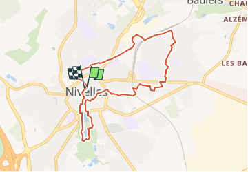
12,8 km | 15 km-effort
3h 24min
![](https://static1.geolcdn.com/siteimages/upload/files/16400158638029165_repeat_loop_refresh_sync_direction_icon.png)
Ja
![Tour Wandern Nivelles - RB-BW-16 - Raccourci 1 - Par monts et canaux, de part et d’autre de la Thines - Photo](https://media.geolcdn.com/t/375/260/ext.jpg?maxdim=2&url=https%3A%2F%2Fservices.sitytrail.com%2FGeolivesWS%2FDownloadMedia.ashx%3FTrailID%3D221718%26Media%3Ddaedf7ee-f25e-4941-815b-dbbb8c629e47.jpg)
![Wandern Wandern](https://static1.geolcdn.com/sitytour/trail-icons/101.png)
RB-BW-16 - Raccourci 1 - Par monts et canaux, de part et d’autre de la Thines
Wandern
Schwierig
(9)
Nivelles,
Wallonien,
Wallonisch-Brabant,
Belgium
![](/images/other/stat-length.png)
16 km | 18,9 km-effort
4h 17min
![](https://static1.geolcdn.com/siteimages/upload/files/16400158638029165_repeat_loop_refresh_sync_direction_icon.png)
Ja
![Tour Wandern Nivelles - RB-Bw-16_Monstreux - Photo](https://media.geolcdn.com/t/375/260/ext.jpg?maxdim=2&url=https%3A%2F%2Fservices.sitytrail.com%2FGeolivesWS%2FDownloadMedia.ashx%3FTrailID%3D179591%26Media%3D606a627b-9c11-4c95-a0ed-8415395e822e.jpg)
![Wandern Wandern](https://static1.geolcdn.com/sitytour/trail-icons/101.png)
RB-Bw-16_Monstreux
Wandern
Sehr schwierig
(10)
Nivelles,
Wallonien,
Wallonisch-Brabant,
Belgium
![](/images/other/stat-length.png)
20 km | 24 km-effort
5h 24min
![](https://static1.geolcdn.com/siteimages/upload/files/16400158638029165_repeat_loop_refresh_sync_direction_icon.png)
Ja
![Tour Wandern Seneffe - De Arquennes à Monstreux par les vallées de la Thines et de la Samme - Photo](https://media.geolcdn.com/t/375/260/ext.jpg?maxdim=2&url=https%3A%2F%2Fservices.sitytrail.com%2FGeolivesWS%2FDownloadMedia.ashx%3FTrailID%3D127787%26Media%3D79b12576-f9f5-4657-a448-2793aa9c7eb2.JPG)
![Wandern Wandern](https://static1.geolcdn.com/sitytour/trail-icons/101.png)
De Arquennes à Monstreux par les vallées de la Thines et de la Samme
Wandern
Einfach
(6)
Seneffe,
Wallonien,
Hennegau,
Belgium
![](/images/other/stat-length.png)
13,7 km | 15,4 km-effort
3h 30min
![](https://static1.geolcdn.com/siteimages/upload/files/16400158638029165_repeat_loop_refresh_sync_direction_icon.png)
Ja
![Tour Wandern Nivelles - Rando Bornival - Photo](https://media.geolcdn.com/t/375/260/ext.jpg?maxdim=2&url=https%3A%2F%2Fstatic1.geolcdn.com%2Fsiteimages%2Fupload%2Ffiles%2F1553511878bg_sport_marche.png)
![Wandern Wandern](https://static1.geolcdn.com/sitytour/trail-icons/101.png)
Rando Bornival
Wandern
Einfach
(5)
Nivelles,
Wallonien,
Wallonisch-Brabant,
Belgium
![](/images/other/stat-length.png)
13,2 km | 15,9 km-effort
3h 27min
![](https://static1.geolcdn.com/siteimages/upload/files/16400158638029165_repeat_loop_refresh_sync_direction_icon.png)
Ja
![Tour Nordic Walking Seneffe - De Arquennes à Nivelles par le RAVEl et l'ancien canal - Photo](https://media.geolcdn.com/t/375/260/ext.jpg?maxdim=2&url=https%3A%2F%2Fservices.sitytrail.com%2FGeolivesWS%2FDownloadMedia.ashx%3FTrailID%3D268082%26Media%3Dea1a030b-8c73-4fe5-a6f0-117246010a21.jpg)
![Nordic Walking Nordic Walking](https://static1.geolcdn.com/sitytour/trail-icons/102.png)
De Arquennes à Nivelles par le RAVEl et l'ancien canal
Nordic Walking
Medium
(2)
Seneffe,
Wallonien,
Hennegau,
Belgium
![](/images/other/stat-length.png)
9,8 km | 11,1 km-effort
2h 16min
![](https://static1.geolcdn.com/siteimages/upload/files/16400158638029165_repeat_loop_refresh_sync_direction_icon.png)
Ja
![Tour Wandern Seneffe - Rando des 4 villages - Photo](https://media.geolcdn.com/t/375/260/abf679c5-ebe6-4969-9ace-2ef084e6b7fc.jpg&format=jpg&maxdim=2)
![Wandern Wandern](https://static1.geolcdn.com/sitytour/trail-icons/101.png)
Rando des 4 villages
Wandern
Einfach
(2)
Seneffe,
Wallonien,
Hennegau,
Belgium
![](/images/other/stat-length.png)
10,8 km | 12,4 km-effort
2h 57min
![](https://static1.geolcdn.com/siteimages/upload/files/16400158638029165_repeat_loop_refresh_sync_direction_icon.png)
Ja
![Tour Wandern Seneffe - BE-Seneffe - Arquennes - Hameau Les Bois et l'ancien canal - Photo](https://media.geolcdn.com/t/375/260/eb61f70b-cfa0-40f0-88f8-9754f883475d.jpg&format=jpg&maxdim=2)
![Wandern Wandern](https://static1.geolcdn.com/sitytour/trail-icons/101.png)
BE-Seneffe - Arquennes - Hameau Les Bois et l'ancien canal
Wandern
Medium
(4)
Seneffe,
Wallonien,
Hennegau,
Belgium
![](/images/other/stat-length.png)
8,4 km | 9,5 km-effort
1h 52min
![](https://static1.geolcdn.com/siteimages/upload/files/16400158638029165_repeat_loop_refresh_sync_direction_icon.png)
Ja
![Tour Wandern Nivelles - Bornival 1119 - Photo](https://media.geolcdn.com/t/375/260/786746a7-db37-4cff-abae-9c5a1c7421c4.jpg&format=jpg&maxdim=2)
![Wandern Wandern](https://static1.geolcdn.com/sitytour/trail-icons/101.png)
Bornival 1119
Wandern
Einfach
(2)
Nivelles,
Wallonien,
Wallonisch-Brabant,
Belgium
![](/images/other/stat-length.png)
9 km | 10,5 km-effort
2h 7min
![](https://static1.geolcdn.com/siteimages/upload/files/16400158638029165_repeat_loop_refresh_sync_direction_icon.png)
Ja