![](/images/other/stat-length.png)
![Tour Fahrrad Saint-Cyprien - Pyrénées Orientales 7 - Photo](https://media.geolcdn.com/t/1900/400/ext.pjpeg?maxdim=2&url=https%3A%2F%2Fstatic1.geolcdn.com%2Fsiteimages%2Fupload%2Ffiles%2F1524743154velo.jpg)
Pyrénées Orientales 7
bosses21
Benutzer
![Länge](/images/other/stat-length.png)
Länge
86 km
![Maximale Höhe](https://static1.geolcdn.com/siteimages/upload/files/1508320355ic_sort_altitude_max_24dp.png)
Maximale Höhe
617 m
![Positive Höhendifferenz](https://static1.geolcdn.com/siteimages/upload/files/1508320355ic_sort_den_pos_24dp.png)
Positive Höhendifferenz
1152 m
![Km-Effort](/images/other/stat-length.png)
Km-Effort
102 km
![Min. Höhe](https://static1.geolcdn.com/siteimages/upload/files/1508320355ic_sort_altitude_min_24dp.png)
Min. Höhe
3 m
![Negative Höhendifferenz](https://static1.geolcdn.com/siteimages/upload/files/1508320355ic_sort_den_neg_24dp.png)
Negative Höhendifferenz
1152 m
![Boucle](https://static1.geolcdn.com/siteimages/upload/files/16400158638029165_repeat_loop_refresh_sync_direction_icon.png)
Boucle
Ja
Erstellungsdatum :
2014-12-10 00:00:00.0
Letzte Änderung :
2014-12-10 00:00:00.0
![Fahrrad](https://static1.geolcdn.com/sitytour/trail-icons/200.png)
5h49
Schwierigkeit : Medium
![Scannen Sie diesen QR-Code, um die Tour in der SityTrail-Anwendung zu öffnen](https://capi.geolives.com/qq0zvz2zws4bq2lad0pu/sitytour/trails/320486/qr.png?size=200)
Kostenlosegpshiking-Anwendung
Über SityTrail
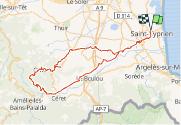
Tour Fahrrad von 86 km verfügbar auf Okzitanien, Ostpyrenäen, Saint-Cyprien. Diese Tour wird von bosses21 vorgeschlagen.
Beschreibung
1. Coll de las Baques - 280m
2. Col dels Francesos - 290m
3. Col de Llauro - 380m
4. Coll de les Pedres Blanques - 485m
5. Collade de Rimbault - 481m
6. La Couillade - 511m
7. Col del Payrou - 603m
Ort
Land:
France
Region :
Okzitanien
Abteilung/Provinz :
Ostpyrenäen
Kommune :
Saint-Cyprien
Standort:
Unknown
Gehen Sie:(Dec)
Gehen Sie:(UTM)
500103 ; 4718961 (31T) N.
Kommentare
Touren in der Umgebung
![Tour Wandern Théza - 66 THEZA - CORNEILLA-DEL-VERCOL - Photo](https://media.geolcdn.com/t/375/260/ext.jpg?maxdim=2&url=https%3A%2F%2Fservices.sitytrail.com%2FGeolivesWS%2FDownloadMedia.ashx%3FTrailID%3D460837%26Media%3D20150818162338.jpg)
![Wandern Wandern](https://static1.geolcdn.com/sitytour/trail-icons/101.png)
66 THEZA - CORNEILLA-DEL-VERCOL
Wandern
Einfach
(2)
Théza,
Okzitanien,
Ostpyrenäen,
France
![](/images/other/stat-length.png)
7 km | 7,5 km-effort
1h 8min
![](https://static1.geolcdn.com/siteimages/upload/files/16400158638029165_repeat_loop_refresh_sync_direction_icon.png)
Ja
![Tour Wandern Saint-Cyprien - SAINT-CYPRIEN 66 - front de mer - les CAPELLANS - Photo](https://media.geolcdn.com/t/375/260/ext.jpg?maxdim=2&url=https%3A%2F%2Fservices.sitytrail.com%2FGeolivesWS%2FDownloadMedia.ashx%3FTrailID%3D433460%26Media%3D20150614130307.jpg)
![Wandern Wandern](https://static1.geolcdn.com/sitytour/trail-icons/101.png)
SAINT-CYPRIEN 66 - front de mer - les CAPELLANS
Wandern
Einfach
(2)
Saint-Cyprien,
Okzitanien,
Ostpyrenäen,
France
![](/images/other/stat-length.png)
9,9 km | 10,3 km-effort
2h 11min
![](https://static1.geolcdn.com/siteimages/upload/files/16400158638029165_repeat_loop_refresh_sync_direction_icon.png)
Ja
![Tour Pferd Saint-Cyprien - bocal du Tech - Photo](https://media.geolcdn.com/t/375/260/ext.jpg?maxdim=2&url=https%3A%2F%2Fservices.sitytrail.com%2FGeolivesWS%2FDownloadMedia.ashx%3FTrailID%3D722669%26Media%3Dfix__20170329121949.jpg)
![Pferd Pferd](https://static1.geolcdn.com/sitytour/trail-icons/300.png)
bocal du Tech
Pferd
Medium
(1)
Saint-Cyprien,
Okzitanien,
Ostpyrenäen,
France
![](/images/other/stat-length.png)
17 km | 17,7 km-effort
3h 20min
![](https://static1.geolcdn.com/siteimages/upload/files/16400158638029165_repeat_loop_refresh_sync_direction_icon.png)
Ja
![Tour Wandern Saleilles - 66 SALEILLES - St-NAZAIRE, entre FOSSEILLE et REART - Photo](https://media.geolcdn.com/t/375/260/ext.jpg?maxdim=2&url=https%3A%2F%2Fstatic1.geolcdn.com%2Fsiteimages%2Fupload%2Ffiles%2F1553511878bg_sport_marche.png)
![Wandern Wandern](https://static1.geolcdn.com/sitytour/trail-icons/101.png)
66 SALEILLES - St-NAZAIRE, entre FOSSEILLE et REART
Wandern
Einfach
(1)
Saleilles,
Okzitanien,
Ostpyrenäen,
France
![](/images/other/stat-length.png)
7,3 km | 7,7 km-effort
1h 8min
![](https://static1.geolcdn.com/siteimages/upload/files/16400158638029165_repeat_loop_refresh_sync_direction_icon.png)
Ja
![Tour Wandern Corneilla-del-Vercol - thématique mo tescot du 18 02 2023 - Photo](https://media.geolcdn.com/t/375/260/ext.jpg?maxdim=2&url=https%3A%2F%2Fmedia.geolcdn.com%2Ff%2Fc486579c-e3ee-457f-8014-e2e51dcdf4f6.jpg)
![Wandern Wandern](https://static1.geolcdn.com/sitytour/trail-icons/101.png)
thématique mo tescot du 18 02 2023
Wandern
Medium
(1)
Corneilla-del-Vercol,
Okzitanien,
Ostpyrenäen,
France
![](/images/other/stat-length.png)
8,9 km | 9,4 km-effort
1h 57min
![](https://static1.geolcdn.com/siteimages/upload/files/16400158638029165_repeat_loop_refresh_sync_direction_icon.png)
Ja
![Tour Wandern Saint-Cyprien - 66 SAINT-CYPRIEN - ALENYA - LATOUR-BAS-ELNE - de berges en berges - Photo](https://media.geolcdn.com/t/375/260/ext.jpg?maxdim=2&url=https%3A%2F%2Fservices.sitytrail.com%2FGeolivesWS%2FDownloadMedia.ashx%3FTrailID%3D464353%26Media%3D20150826171438.jpg)
![Wandern Wandern](https://static1.geolcdn.com/sitytour/trail-icons/101.png)
66 SAINT-CYPRIEN - ALENYA - LATOUR-BAS-ELNE - de berges en berges
Wandern
Medium
Saint-Cyprien,
Okzitanien,
Ostpyrenäen,
France
![](/images/other/stat-length.png)
7,9 km | 8,3 km-effort
1h 16min
![](https://static1.geolcdn.com/siteimages/upload/files/16400158638029165_repeat_loop_refresh_sync_direction_icon.png)
Ja
![Tour Wandern Saint-Cyprien - SAINT-CYPRIEN SUD 66 - Le bocal du TECH - Photo](https://media.geolcdn.com/t/375/260/ext.jpg?maxdim=2&url=https%3A%2F%2Fservices.sitytrail.com%2FGeolivesWS%2FDownloadMedia.ashx%3FTrailID%3D434175%26Media%3D20150615174545.jpg)
![Wandern Wandern](https://static1.geolcdn.com/sitytour/trail-icons/101.png)
SAINT-CYPRIEN SUD 66 - Le bocal du TECH
Wandern
Einfach
(1)
Saint-Cyprien,
Okzitanien,
Ostpyrenäen,
France
![](/images/other/stat-length.png)
6,5 km | 6,8 km-effort
1h 20min
![](https://static1.geolcdn.com/siteimages/upload/files/16400158638029165_repeat_loop_refresh_sync_direction_icon.png)
Ja
![Tour Wandern Argelès-sur-Mer - MAS LARRIEU - ARGELES-SUR-MER 66 - autour de la réserve naturelle, le littoral et retour par l'embouchure du TECH - Photo](https://media.geolcdn.com/t/375/260/ext.jpg?maxdim=2&url=https%3A%2F%2Fservices.sitytrail.com%2FGeolivesWS%2FDownloadMedia.ashx%3FTrailID%3D432516%26Media%3D20150611185204.jpg)
![Wandern Wandern](https://static1.geolcdn.com/sitytour/trail-icons/101.png)
MAS LARRIEU - ARGELES-SUR-MER 66 - autour de la réserve naturelle, le littora...
Wandern
Medium
(1)
Argelès-sur-Mer,
Okzitanien,
Ostpyrenäen,
France
![](/images/other/stat-length.png)
13,6 km | 14,3 km-effort
2h 24min
![](https://static1.geolcdn.com/siteimages/upload/files/16400158638029165_repeat_loop_refresh_sync_direction_icon.png)
Ja
![Tour Wandern Elne - ALENYA 66 - entre l'Agouille de la Mar et le Réart - Photo](https://media.geolcdn.com/t/375/260/ext.jpg?maxdim=2&url=https%3A%2F%2Fservices.sitytrail.com%2FGeolivesWS%2FDownloadMedia.ashx%3FTrailID%3D423792%26Media%3D20150521181605.jpg)
![Wandern Wandern](https://static1.geolcdn.com/sitytour/trail-icons/101.png)
ALENYA 66 - entre l'Agouille de la Mar et le Réart
Wandern
Einfach
Elne,
Okzitanien,
Ostpyrenäen,
France
![](/images/other/stat-length.png)
12,6 km | 13,1 km-effort
1h 57min
![](https://static1.geolcdn.com/siteimages/upload/files/16400158638029165_repeat_loop_refresh_sync_direction_icon.png)
Ja