![](/images/other/stat-length.png)
![Tour Reiten Egelshardt - 2022-04-10 WE CVA Eguelshardt Châteaux - Photo](https://media.geolcdn.com/t/1900/400/ext.pjpeg?maxdim=2&url=https%3A%2F%2Fstatic1.geolcdn.com%2Fsiteimages%2Fupload%2Ffiles%2F1524743154cheval.jpg)
2022-04-10 WE CVA Eguelshardt Châteaux
holtzv
Benutzer GUIDE
![Länge](/images/other/stat-length.png)
Länge
28 km
![Maximale Höhe](https://static1.geolcdn.com/siteimages/upload/files/1508320355ic_sort_altitude_max_24dp.png)
Maximale Höhe
363 m
![Positive Höhendifferenz](https://static1.geolcdn.com/siteimages/upload/files/1508320355ic_sort_den_pos_24dp.png)
Positive Höhendifferenz
573 m
![Km-Effort](/images/other/stat-length.png)
Km-Effort
36 km
![Min. Höhe](https://static1.geolcdn.com/siteimages/upload/files/1508320355ic_sort_altitude_min_24dp.png)
Min. Höhe
238 m
![Negative Höhendifferenz](https://static1.geolcdn.com/siteimages/upload/files/1508320355ic_sort_den_neg_24dp.png)
Negative Höhendifferenz
572 m
![Boucle](https://static1.geolcdn.com/siteimages/upload/files/16400158638029165_repeat_loop_refresh_sync_direction_icon.png)
Boucle
Ja
Erstellungsdatum :
2022-04-10 07:37:31.185
Letzte Änderung :
2022-04-11 09:48:11.953
![Reiten](https://static1.geolcdn.com/sitytour/trail-icons/301.png)
5h42
Schwierigkeit : Schwierig
![Scannen Sie diesen QR-Code, um die Tour in der SityTrail-Anwendung zu öffnen](https://capi.geolives.com/qq0zvz2zws4bq2lad0pu/sitytour/trails/3199499/qr.png?size=200)
Kostenlosegpshiking-Anwendung
Über SityTrail
Tour Reiten von 28 km verfügbar auf Großer Osten, Mosel, Egelshardt. Diese Tour wird von holtzv vorgeschlagen.
Beschreibung
Pause déjeuner dans un pré avant le parking du Château de Rothenbourg
Etang de Hanau
Château du Falkenstein
Blockhaus
Château de Rothenbourg
Notre-Dame des Bois
Erbsenfelsen
Château de Waldeck et son Etang
Ort
Land:
France
Region :
Großer Osten
Abteilung/Provinz :
Mosel
Kommune :
Egelshardt
Standort:
Unknown
Gehen Sie:(Dec)
Gehen Sie:(UTM)
390628 ; 5431022 (32U) N.
Kommentare
Touren in der Umgebung
![Tour Wandern Egelshardt - Notre Dame des Bois - Photo](https://media.geolcdn.com/t/375/260/3cf87b27-a59c-4ea6-a7bf-d652826f7266.jpg&format=jpg&maxdim=2)
![Wandern Wandern](https://static1.geolcdn.com/sitytour/trail-icons/101.png)
Notre Dame des Bois
Wandern
Medium
(1)
Egelshardt,
Großer Osten,
Mosel,
France
![](/images/other/stat-length.png)
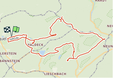
17,3 km | 24 km-effort
4h 4min
![](https://static1.geolcdn.com/siteimages/upload/files/16400158638029165_repeat_loop_refresh_sync_direction_icon.png)
Ja
![Tour Wandern Bitsch - Etang de Hasselfurth et Hochkopf - Bitche - Photo](https://media.geolcdn.com/t/375/260/ext.jpg?maxdim=2&url=https%3A%2F%2Fservices.sitytrail.com%2FGeolivesWS%2FDownloadMedia.ashx%3FTrailID%3D317857%26Media%3D17240_6.jpg)
![Wandern Wandern](https://static1.geolcdn.com/sitytour/trail-icons/101.png)
Etang de Hasselfurth et Hochkopf - Bitche
Wandern
Medium
(1)
Bitsch,
Großer Osten,
Mosel,
France
![](/images/other/stat-length.png)
7,8 km | 10,1 km-effort
2h 0min
![](https://static1.geolcdn.com/siteimages/upload/files/16400158638029165_repeat_loop_refresh_sync_direction_icon.png)
Ja
![Tour Wandern Philippsburg - Les 3 châteaux : Falkenstein, Rothenbourg, Waldeck - Photo](https://media.geolcdn.com/t/375/260/ext.jpg?maxdim=2&url=https%3A%2F%2Fservices.sitytrail.com%2FGeolivesWS%2FDownloadMedia.ashx%3FTrailID%3D118668%26Media%3D12831_5.jpg)
![Wandern Wandern](https://static1.geolcdn.com/sitytour/trail-icons/101.png)
Les 3 châteaux : Falkenstein, Rothenbourg, Waldeck
Wandern
Schwierig
(1)
Philippsburg,
Großer Osten,
Mosel,
France
![](/images/other/stat-length.png)
16,1 km | 22 km-effort
4h 25min
![](https://static1.geolcdn.com/siteimages/upload/files/16400158638029165_repeat_loop_refresh_sync_direction_icon.png)
Ja
![Tour Wandern Bitsch - Étang Hasselfurth 250112 - Photo](https://media.geolcdn.com/t/375/260/3662900e-8205-4856-9f76-ac80e91a6fa5.jpg&format=jpg&maxdim=2)
![Wandern Wandern](https://static1.geolcdn.com/sitytour/trail-icons/101.png)
Étang Hasselfurth 250112
Wandern
Medium
Bitsch,
Großer Osten,
Mosel,
France
![](/images/other/stat-length.png)
9,9 km | 13,1 km-effort
3h 0min
![](https://static1.geolcdn.com/siteimages/upload/files/16400158638029165_repeat_loop_refresh_sync_direction_icon.png)
Ja
![Tour Zu Fuß Philippsburg - Gelbes Kreuz liegend auf weißem Grund - Photo](https://media.geolcdn.com/t/375/260/405334b8-fc9f-4697-8248-e0a1e7aa1239.jpeg&format=jpg&maxdim=2)
![Zu Fuß Zu Fuß](https://static1.geolcdn.com/sitytour/trail-icons/100.png)
Gelbes Kreuz liegend auf weißem Grund
Zu Fuß
Einfach
Philippsburg,
Großer Osten,
Mosel,
France
![](/images/other/stat-length.png)
7,5 km | 11 km-effort
2h 29min
![](https://static1.geolcdn.com/siteimages/upload/files/16400158638029165_repeat_loop_refresh_sync_direction_icon.png)
Nein
![Tour Zu Fuß Philippsburg - Roter Punkt - Photo](https://media.geolcdn.com/t/375/260/41711dff-01c3-4002-aacf-819b06d7da02.jpeg&format=jpg&maxdim=2)
![Zu Fuß Zu Fuß](https://static1.geolcdn.com/sitytour/trail-icons/100.png)
Roter Punkt
Zu Fuß
Einfach
Philippsburg,
Großer Osten,
Mosel,
France
![](/images/other/stat-length.png)
6 km | 9,3 km-effort
2h 7min
![](https://static1.geolcdn.com/siteimages/upload/files/16400158638029165_repeat_loop_refresh_sync_direction_icon.png)
Nein
![Tour Zu Fuß Philippsburg - Rotes Dreieck - Photo](https://media.geolcdn.com/t/375/260/41711dff-01c3-4002-aacf-819b06d7da02.jpeg&format=jpg&maxdim=2)
![Zu Fuß Zu Fuß](https://static1.geolcdn.com/sitytour/trail-icons/100.png)
Rotes Dreieck
Zu Fuß
Einfach
Philippsburg,
Großer Osten,
Mosel,
France
![](/images/other/stat-length.png)
5,1 km | 7,3 km-effort
1h 39min
![](https://static1.geolcdn.com/siteimages/upload/files/16400158638029165_repeat_loop_refresh_sync_direction_icon.png)
Nein
![Tour Zu Fuß Bärental - Gelber Ring - Photo](https://media.geolcdn.com/t/375/260/c97fa14f-913f-4d0c-9e00-fb1aec3cafd9.jpeg&format=jpg&maxdim=2)
![Zu Fuß Zu Fuß](https://static1.geolcdn.com/sitytour/trail-icons/100.png)
Gelber Ring
Zu Fuß
Einfach
Bärental,
Großer Osten,
Mosel,
France
![](/images/other/stat-length.png)
12,3 km | 15,3 km-effort
3h 28min
![](https://static1.geolcdn.com/siteimages/upload/files/16400158638029165_repeat_loop_refresh_sync_direction_icon.png)
Ja
![Tour Zu Fuß Philippsburg - Goldenberg-Pfad - Photo](https://media.geolcdn.com/t/375/260/6348f4f6-901a-4514-89c9-fdb6087d121c.jpeg&format=jpg&maxdim=2)
![Zu Fuß Zu Fuß](https://static1.geolcdn.com/sitytour/trail-icons/100.png)
Goldenberg-Pfad
Zu Fuß
Einfach
Philippsburg,
Großer Osten,
Mosel,
France
![](/images/other/stat-length.png)
5,3 km | 7,1 km-effort
1h 36min
![](https://static1.geolcdn.com/siteimages/upload/files/16400158638029165_repeat_loop_refresh_sync_direction_icon.png)
Nein