![](/images/other/stat-length.png)
![Tour Wandern Étalle - La foret de Chantemelle - Photo](https://media.geolcdn.com/t/1900/400/ext.pjpeg?maxdim=2&url=https%3A%2F%2Fstatic1.geolcdn.com%2Fsiteimages%2Fupload%2Ffiles%2F1553511878bg_sport_marche.png)
La foret de Chantemelle
Gaume tranquille
Passion Nature Contemplation
![Länge](/images/other/stat-length.png)
Länge
8 km
![Maximale Höhe](https://static1.geolcdn.com/siteimages/upload/files/1508320355ic_sort_altitude_max_24dp.png)
Maximale Höhe
363 m
![Positive Höhendifferenz](https://static1.geolcdn.com/siteimages/upload/files/1508320355ic_sort_den_pos_24dp.png)
Positive Höhendifferenz
140 m
![Km-Effort](/images/other/stat-length.png)
Km-Effort
9,8 km
![Min. Höhe](https://static1.geolcdn.com/siteimages/upload/files/1508320355ic_sort_altitude_min_24dp.png)
Min. Höhe
277 m
![Negative Höhendifferenz](https://static1.geolcdn.com/siteimages/upload/files/1508320355ic_sort_den_neg_24dp.png)
Negative Höhendifferenz
141 m
![Boucle](https://static1.geolcdn.com/siteimages/upload/files/16400158638029165_repeat_loop_refresh_sync_direction_icon.png)
Boucle
Ja
Erstellungsdatum :
2022-04-03 13:38:51.496
Letzte Änderung :
2022-05-21 05:28:43.887
![Wandern](https://static1.geolcdn.com/sitytour/trail-icons/101.png)
2h08
Schwierigkeit : Medium
![Scannen Sie diesen QR-Code, um die Tour in der SityTrail-Anwendung zu öffnen](https://capi.geolives.com/qq0zvz2zws4bq2lad0pu/sitytour/trails/3190816/qr.png?size=200)
Kostenlosegpshiking-Anwendung
Über SityTrail
Tour Wandern von 8 km verfügbar auf Wallonien, Luxemburg, Étalle. Diese Tour wird von Gaume tranquille vorgeschlagen.
Beschreibung
Jolie balade printanière à travers bois et campagne fleurie.
Ort
Land:
Belgium
Region :
Wallonien
Abteilung/Provinz :
Luxemburg
Kommune :
Étalle
Standort:
Vance
Gehen Sie:(Dec)
Gehen Sie:(UTM)
692609 ; 5501638 (31U) N.
Kommentare
Touren in der Umgebung
![Tour Wandern Zillig - RF-Lu-14 - Au pays des lavoirs anciens et des usoirs : Châtillon - Photo](https://media.geolcdn.com/t/375/260/ext.jpg?maxdim=2&url=https%3A%2F%2Fservices.sitytrail.com%2FGeolivesWS%2FDownloadMedia.ashx%3FTrailID%3D407136%26Media%3D623ce8e1-010c-490a-9987-548abb1b02b7.jpg)
![Wandern Wandern](https://static1.geolcdn.com/sitytour/trail-icons/101.png)
RF-Lu-14 - Au pays des lavoirs anciens et des usoirs : Châtillon
Wandern
Sehr leicht
(1)
Zillig,
Wallonien,
Luxemburg,
Belgium
![](/images/other/stat-length.png)
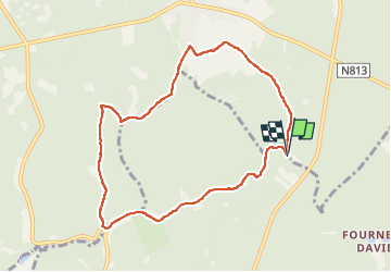
12,6 km | 16,2 km-effort
3h 29min
![](https://static1.geolcdn.com/siteimages/upload/files/16400158638029165_repeat_loop_refresh_sync_direction_icon.png)
Ja
![Tour Mountainbike Étalle - O2bikers_26_etalle - Photo](https://media.geolcdn.com/t/375/260/ext.jpg?maxdim=2&url=https%3A%2F%2Fstatic1.geolcdn.com%2Fsiteimages%2Fupload%2Ffiles%2F1524743154velo.jpg)
![Mountainbike Mountainbike](https://static1.geolcdn.com/sitytour/trail-icons/202.png)
O2bikers_26_etalle
Mountainbike
Sehr leicht
(1)
Étalle,
Wallonien,
Luxemburg,
Belgium
![](/images/other/stat-length.png)
22 km | 27 km-effort
3h 0min
![](https://static1.geolcdn.com/siteimages/upload/files/16400158638029165_repeat_loop_refresh_sync_direction_icon.png)
Ja
![Tour Wandern Étalle - GAUME Boucle vers la vallee de la Rougeau - Photo](https://media.geolcdn.com/t/375/260/ext.jpg?maxdim=2&url=https%3A%2F%2Fstatic1.geolcdn.com%2Fsiteimages%2Fupload%2Ffiles%2F1553511878bg_sport_marche.png)
![Wandern Wandern](https://static1.geolcdn.com/sitytour/trail-icons/101.png)
GAUME Boucle vers la vallee de la Rougeau
Wandern
Einfach
(3)
Étalle,
Wallonien,
Luxemburg,
Belgium
![](/images/other/stat-length.png)
5,6 km | 7,1 km-effort
1h 32min
![](https://static1.geolcdn.com/siteimages/upload/files/16400158638029165_repeat_loop_refresh_sync_direction_icon.png)
Ja
![Tour Wandern Zillig - GAUME Balade dans les dunes de chatillon - Photo](https://media.geolcdn.com/t/375/260/ext.jpg?maxdim=2&url=https%3A%2F%2Fstatic1.geolcdn.com%2Fsiteimages%2Fupload%2Ffiles%2F1553511878bg_sport_marche.png)
![Wandern Wandern](https://static1.geolcdn.com/sitytour/trail-icons/101.png)
GAUME Balade dans les dunes de chatillon
Wandern
Sehr leicht
(1)
Zillig,
Wallonien,
Luxemburg,
Belgium
![](/images/other/stat-length.png)
3,6 km | 4,4 km-effort
58min
![](https://static1.geolcdn.com/siteimages/upload/files/16400158638029165_repeat_loop_refresh_sync_direction_icon.png)
Ja
![Tour Wandern Étalle - Chantemelle la tranchée des portes - Photo](https://media.geolcdn.com/t/375/260/61188bc8-d295-4809-ba0b-7ca5757e1f85.jpg&format=jpg&maxdim=2)
![Wandern Wandern](https://static1.geolcdn.com/sitytour/trail-icons/101.png)
Chantemelle la tranchée des portes
Wandern
Einfach
Étalle,
Wallonien,
Luxemburg,
Belgium
![](/images/other/stat-length.png)
10,8 km | 12,6 km-effort
2h 30min
![](https://static1.geolcdn.com/siteimages/upload/files/16400158638029165_repeat_loop_refresh_sync_direction_icon.png)
Ja
![Tour Wandern Zillig - Tranchée des Portes - Marche_8kms - Photo](https://media.geolcdn.com/t/375/260/69c613ab-f3c0-4517-a051-3dfe16f77f7f.jpg&format=jpg&maxdim=2)
![Wandern Wandern](https://static1.geolcdn.com/sitytour/trail-icons/101.png)
Tranchée des Portes - Marche_8kms
Wandern
Schwierig
Zillig,
Wallonien,
Luxemburg,
Belgium
![](/images/other/stat-length.png)
7,8 km | 10,2 km-effort
1h 44min
![](https://static1.geolcdn.com/siteimages/upload/files/16400158638029165_repeat_loop_refresh_sync_direction_icon.png)
Nein
![Tour Zu Fuß Zillig - “From bell tower to bell tower](https://media.geolcdn.com/t/375/260/ext.jpg?maxdim=2&url=https%3A%2F%2Fpivotmedia.tourismewallonie.be%2FOTH-A0-006F-13YF%2FOTH-A0-006F-13YF.jpg)
![Zu Fuß Zu Fuß](https://static1.geolcdn.com/sitytour/trail-icons/100.png)
“From bell tower to bell tower"
Zu Fuß
Einfach
Zillig,
Wallonien,
Luxemburg,
Belgium
![](/images/other/stat-length.png)
7,2 km | 8,9 km-effort
2h 0min
![](https://static1.geolcdn.com/siteimages/upload/files/16400158638029165_repeat_loop_refresh_sync_direction_icon.png)
Ja
![Tour Zu Fuß Étalle - La Stabuloise - Photo](https://media.geolcdn.com/t/375/260/ext.jpg?maxdim=2&url=https%3A%2F%2Fpivotmedia.tourismewallonie.be%2FOTH-A0-006F-3F6K%2FOTH-A0-006F-3F6K.jpg)
![Zu Fuß Zu Fuß](https://static1.geolcdn.com/sitytour/trail-icons/100.png)
La Stabuloise
Zu Fuß
Einfach
Étalle,
Wallonien,
Luxemburg,
Belgium
![](/images/other/stat-length.png)
13,5 km | 15,5 km-effort
3h 30min
![](https://static1.geolcdn.com/siteimages/upload/files/16400158638029165_repeat_loop_refresh_sync_direction_icon.png)
Ja
![Tour Zu Fuß Zillig - Promenade à Sint-Ldjir - Photo](https://media.geolcdn.com/t/375/260/ext.jpg?maxdim=2&url=https%3A%2F%2Fpivotmedia.tourismewallonie.be%2FOTH-A0-006F-3S15%2FOTH-A0-006F-3S15.jpg)
![Zu Fuß Zu Fuß](https://static1.geolcdn.com/sitytour/trail-icons/100.png)
Promenade à Sint-Ldjir
Zu Fuß
Einfach
Zillig,
Wallonien,
Luxemburg,
Belgium
![](/images/other/stat-length.png)
5,9 km | 7,3 km-effort
1h 39min
![](https://static1.geolcdn.com/siteimages/upload/files/16400158638029165_repeat_loop_refresh_sync_direction_icon.png)
Ja