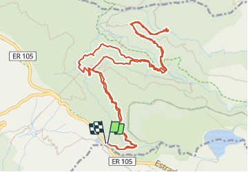
![](/images/other/stat-length.png)
![Tour Wandern Calheta - Madère : de Rabaçal vers les 25 sources - Photo](https://media.geolcdn.com/t/1900/400/c0fcee6c-1b6e-44b1-aed5-efb4d40aa24c.jpg&format=pjpeg&maxdim=2)
Madère : de Rabaçal vers les 25 sources
Bart2015
Benutzer
![Länge](/images/other/stat-length.png)
![Maximale Höhe](https://static1.geolcdn.com/siteimages/upload/files/1508320355ic_sort_altitude_max_24dp.png)
![Positive Höhendifferenz](https://static1.geolcdn.com/siteimages/upload/files/1508320355ic_sort_den_pos_24dp.png)
![Km-Effort](/images/other/stat-length.png)
![Min. Höhe](https://static1.geolcdn.com/siteimages/upload/files/1508320355ic_sort_altitude_min_24dp.png)
![Negative Höhendifferenz](https://static1.geolcdn.com/siteimages/upload/files/1508320355ic_sort_den_neg_24dp.png)
![Boucle](https://static1.geolcdn.com/siteimages/upload/files/16400158638029165_repeat_loop_refresh_sync_direction_icon.png)
![Wandern](https://static1.geolcdn.com/sitytour/trail-icons/101.png)
3h18
Schwierigkeit : Medium
![Scannen Sie diesen QR-Code, um die Tour in der SityTrail-Anwendung zu öffnen](https://capi.geolives.com/qq0zvz2zws4bq2lad0pu/sitytour/trails/3189308/qr.png?size=200)
Kostenlosegpshiking-Anwendung
Über SityTrail
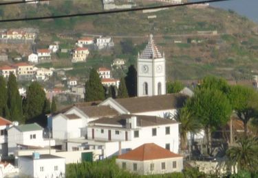
Tour Wandern von 9,5 km verfügbar auf Madeira, Unbekannt, Calheta. Diese Tour wird von Bart2015 vorgeschlagen.
Beschreibung
Randonnée très bien décrite dans le Rother Madère - n°51.
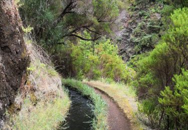
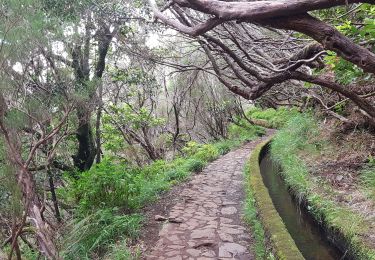
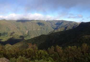
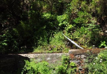
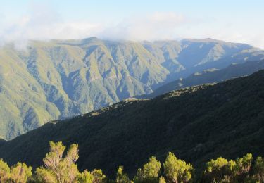
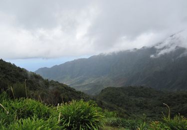
Très belle randonnée qui conduit à une magnifique cascade et ses 25 sources en longeant pour une bonne partie une levada ancienne au travers des gorges profondes de la Ribeira Grande. Physique pour la descente et la remontée, un minibus est en place pour descendre et/ou remonter du point de départ au bar de Rabaçal.
Bonne rando ...
Ort
Kommentare
Touren in der Umgebung
![Tour Wandern Calheta - chemin des cascades - Photo](https://media.geolcdn.com/t/375/260/c00528eb-97aa-45b4-9ff1-b112575f8736.jpg&format=jpg&maxdim=2)
![Wandern Wandern](https://static1.geolcdn.com/sitytour/trail-icons/101.png)
Wandern
![](/images/other/stat-length.png)
![](https://static1.geolcdn.com/siteimages/upload/files/16400158638029165_repeat_loop_refresh_sync_direction_icon.png)
![Tour Andere Aktivitäten Calheta - levada 25 sources variante 13 km - Photo](https://media.geolcdn.com/t/375/260/ext.jpg?maxdim=2&url=https%3A%2F%2Fstatic1.geolcdn.com%2Fsiteimages%2Fupload%2Ffiles%2F1545311037marcheuse_200dpi.jpg)
![Andere Aktivitäten Andere Aktivitäten](https://static1.geolcdn.com/sitytour/trail-icons/900.png)
Andere Aktivitäten
![](/images/other/stat-length.png)
![](https://static1.geolcdn.com/siteimages/upload/files/16400158638029165_repeat_loop_refresh_sync_direction_icon.png)
![Tour Wandern Arco da Calheta - Levada do 25 fontes - Photo](https://media.geolcdn.com/t/375/260/6039bf7b-1eb8-4247-b95e-55a7995178bd.jpg&format=jpg&maxdim=2)
![Wandern Wandern](https://static1.geolcdn.com/sitytour/trail-icons/101.png)
Wandern
![](/images/other/stat-length.png)
![](https://static1.geolcdn.com/siteimages/upload/files/16400158638029165_repeat_loop_refresh_sync_direction_icon.png)
![Tour Zu Fuß Ponta do Pargo - Vereda do Galhano - Photo](https://media.geolcdn.com/t/375/260/d5210e3e-3c5f-4efd-8d97-62e17b3ac8f4.jpeg&format=jpg&maxdim=2)
![Zu Fuß Zu Fuß](https://static1.geolcdn.com/sitytour/trail-icons/100.png)
Zu Fuß
![](/images/other/stat-length.png)
![](https://static1.geolcdn.com/siteimages/upload/files/16400158638029165_repeat_loop_refresh_sync_direction_icon.png)
![Tour Zu Fuß Calheta - Vereda da Lagoa do Vento - Photo](https://media.geolcdn.com/t/375/260/759818e7-feb7-4f26-8e4c-72cd59be231e.jpeg&format=jpg&maxdim=2)
![Zu Fuß Zu Fuß](https://static1.geolcdn.com/sitytour/trail-icons/100.png)
Zu Fuß
![](/images/other/stat-length.png)
![](https://static1.geolcdn.com/siteimages/upload/files/16400158638029165_repeat_loop_refresh_sync_direction_icon.png)
![Tour Zu Fuß Calheta - Levada do Alecrim - Photo](https://media.geolcdn.com/t/375/260/3dca4bbc-701e-47b5-afc8-fdf0d6c5f730.jpeg&format=jpg&maxdim=2)
![Zu Fuß Zu Fuß](https://static1.geolcdn.com/sitytour/trail-icons/100.png)
Zu Fuß
![](/images/other/stat-length.png)
![](https://static1.geolcdn.com/siteimages/upload/files/16400158638029165_repeat_loop_refresh_sync_direction_icon.png)
![Tour Zu Fuß Arco da Calheta - Levada do Paul - Photo](https://media.geolcdn.com/t/375/260/8e21c2f2-cd7e-48f5-8ce7-57f2489de0d5.jpeg&format=jpg&maxdim=2)
![Zu Fuß Zu Fuß](https://static1.geolcdn.com/sitytour/trail-icons/100.png)
Zu Fuß
![](/images/other/stat-length.png)
![](https://static1.geolcdn.com/siteimages/upload/files/16400158638029165_repeat_loop_refresh_sync_direction_icon.png)
![Tour Zu Fuß Calheta - Vereda do Lombo Barbinhas - Photo](https://media.geolcdn.com/t/375/260/db3e98f8-7ea7-41b7-b359-5ab0ad41297d.jpeg&format=jpg&maxdim=2)
![Zu Fuß Zu Fuß](https://static1.geolcdn.com/sitytour/trail-icons/100.png)
Zu Fuß
![](/images/other/stat-length.png)
![](https://static1.geolcdn.com/siteimages/upload/files/16400158638029165_repeat_loop_refresh_sync_direction_icon.png)
![Tour Zu Fuß Ponta do Sol - Levada do Coronel - Photo](https://media.geolcdn.com/t/375/260/46fdaffc-82f7-458b-af4e-512906ebe29f.jpeg&format=jpg&maxdim=2)
![Zu Fuß Zu Fuß](https://static1.geolcdn.com/sitytour/trail-icons/100.png)
Zu Fuß
![](/images/other/stat-length.png)
![](https://static1.geolcdn.com/siteimages/upload/files/16400158638029165_repeat_loop_refresh_sync_direction_icon.png)