![](/images/other/stat-length.png)
![Tour Wandern Saint-André-de-Majencoules - Col de Dévinayré - Saint André de Majencoules - Photo](https://media.geolcdn.com/t/1900/400/ext.pjpeg?maxdim=2&url=https%3A%2F%2Fservices.sitytrail.com%2FGeolivesWS%2FDownloadMedia.ashx%3FTrailID%3D318061%26Media%3D17537_6.jpg)
Col de Dévinayré - Saint André de Majencoules
tracegps
Benutzer
![Länge](/images/other/stat-length.png)
![Maximale Höhe](https://static1.geolcdn.com/siteimages/upload/files/1508320355ic_sort_altitude_max_24dp.png)
![Positive Höhendifferenz](https://static1.geolcdn.com/siteimages/upload/files/1508320355ic_sort_den_pos_24dp.png)
![Km-Effort](/images/other/stat-length.png)
![Min. Höhe](https://static1.geolcdn.com/siteimages/upload/files/1508320355ic_sort_altitude_min_24dp.png)
![Negative Höhendifferenz](https://static1.geolcdn.com/siteimages/upload/files/1508320355ic_sort_den_neg_24dp.png)
![Boucle](https://static1.geolcdn.com/siteimages/upload/files/16400158638029165_repeat_loop_refresh_sync_direction_icon.png)
![Wandern](https://static1.geolcdn.com/sitytour/trail-icons/101.png)
5h30
Schwierigkeit : Schwierig
![Scannen Sie diesen QR-Code, um die Tour in der SityTrail-Anwendung zu öffnen](https://capi.geolives.com/qq0zvz2zws4bq2lad0pu/sitytour/trails/318061/qr.png?size=200)
Kostenlosegpshiking-Anwendung
Über SityTrail
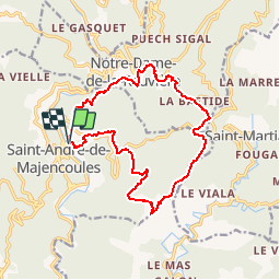
Tour Wandern von 16,2 km verfügbar auf Okzitanien, Gard, Saint-André-de-Majencoules. Diese Tour wird von tracegps vorgeschlagen.
Beschreibung
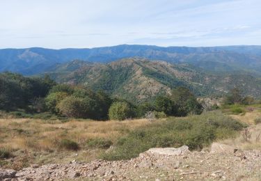
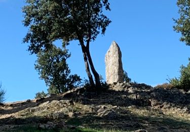
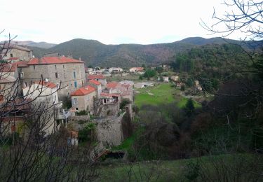
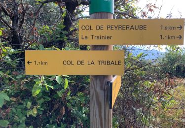
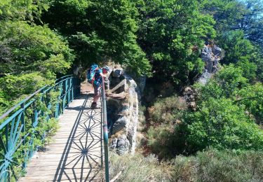
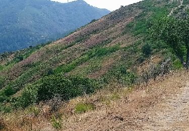
Départ du parking après le pont, en direction du col de la Trivale (D420). Aller au poteau les Tronquisses puis à gauche, monter entre les maisons aux jardins fleuris. Passer la Baraque puis la Blaquiére. Suivre le sentier agréable dans les châtaigniers pour arriver à Ambec afin de suivre une petite route goudronnée que l'on quitte par la gauche pour suivre un sentier qui monte raide vers ND de la Rouvière. Partir en direction du col de la Tribale, de là, suivre col du Dévinayré puis col de Peyreraube; descendre au Valat de Coulisse, remonter à Valbonne haut puis au col de Cabone avant de redescendre au parking du départ. Bonne rando.
Ort
Kommentare
Touren in der Umgebung
![Tour Wandern Saint-Martial - Montagne du Liron au départ de St Martial - Photo](https://media.geolcdn.com/t/375/260/230ffbae-9a5c-40a3-841b-ca21b92f7b5b.jpg&format=jpg&maxdim=2)
![Wandern Wandern](https://static1.geolcdn.com/sitytour/trail-icons/101.png)
Wandern
![](/images/other/stat-length.png)
![](https://static1.geolcdn.com/siteimages/upload/files/16400158638029165_repeat_loop_refresh_sync_direction_icon.png)
![Tour Wandern Saint-André-de-Majencoules - Pont d Herault - Photo](https://media.geolcdn.com/t/375/260/d856160b-56dc-4e09-bd64-d026d26891ce.jpg&format=jpg&maxdim=2)
![Wandern Wandern](https://static1.geolcdn.com/sitytour/trail-icons/101.png)
Wandern
![](/images/other/stat-length.png)
![](https://static1.geolcdn.com/siteimages/upload/files/16400158638029165_repeat_loop_refresh_sync_direction_icon.png)
![Tour Wandern Saint-André-de-Majencoules - les Hameaux de Pont d'Herault variante - Photo](https://media.geolcdn.com/t/375/260/6b52f0de-e793-4785-b4db-952bd9b70cf6.jpg&format=jpg&maxdim=2)
![Wandern Wandern](https://static1.geolcdn.com/sitytour/trail-icons/101.png)
Wandern
![](/images/other/stat-length.png)
![](https://static1.geolcdn.com/siteimages/upload/files/16400158638029165_repeat_loop_refresh_sync_direction_icon.png)
![Tour Wandern Saint-Martial - arsel saint martial - Photo](https://media.geolcdn.com/t/375/260/7eb2b09d-8664-4214-8948-fa1b3d75088d.jpg&format=jpg&maxdim=2)
![Wandern Wandern](https://static1.geolcdn.com/sitytour/trail-icons/101.png)
Wandern
![](/images/other/stat-length.png)
![](https://static1.geolcdn.com/siteimages/upload/files/16400158638029165_repeat_loop_refresh_sync_direction_icon.png)
![Tour Wandern Saint-Martial - Le col de la Tribale Le col de Bez Saint Martial - Photo](https://media.geolcdn.com/t/375/260/0af33f45-6d63-4012-ba0f-17fafc71089a.jpg&format=jpg&maxdim=2)
![Wandern Wandern](https://static1.geolcdn.com/sitytour/trail-icons/101.png)
Wandern
![](/images/other/stat-length.png)
![](https://static1.geolcdn.com/siteimages/upload/files/16400158638029165_repeat_loop_refresh_sync_direction_icon.png)
![Tour Wandern Saint-André-de-Majencoules - les grandes collines à partir de St André de majencoules - Photo](https://media.geolcdn.com/t/375/260/d3d95186-cdaa-43c5-b1ca-102ce555d7c3.jpg&format=jpg&maxdim=2)
![Wandern Wandern](https://static1.geolcdn.com/sitytour/trail-icons/101.png)
Wandern
![](/images/other/stat-length.png)
![](https://static1.geolcdn.com/siteimages/upload/files/16400158638029165_repeat_loop_refresh_sync_direction_icon.png)
![Tour Wandern Saint-Martial - Saint Martial - Photo](https://media.geolcdn.com/t/375/260/6552b264-c67d-4bfd-90f2-0d42bbc08d53.jpg&format=jpg&maxdim=2)
![Wandern Wandern](https://static1.geolcdn.com/sitytour/trail-icons/101.png)
![Tour Wandern Val-d'Aigoual - vers les cascades d orgon - Photo](https://media.geolcdn.com/t/375/260/c36172f2-a4b0-40f0-8f24-0e669602d2b7.jpg&format=jpg&maxdim=2)
![Wandern Wandern](https://static1.geolcdn.com/sitytour/trail-icons/101.png)
Wandern
![](/images/other/stat-length.png)
![](https://static1.geolcdn.com/siteimages/upload/files/16400158638029165_repeat_loop_refresh_sync_direction_icon.png)
![Tour Wandern Val-d'Aigoual - notre Dame de la rouviere avec Jacky et alphonse - Photo](https://media.geolcdn.com/t/375/260/ext.jpg?maxdim=2&url=https%3A%2F%2Fservices.sitytrail.com%2FGeolivesWS%2FDownloadMedia.ashx%3FTrailID%3D1031162%26Media%3Dfix__20180830131008.jpg)
![Wandern Wandern](https://static1.geolcdn.com/sitytour/trail-icons/101.png)
Wandern
![](/images/other/stat-length.png)
![](https://static1.geolcdn.com/siteimages/upload/files/16400158638029165_repeat_loop_refresh_sync_direction_icon.png)