![](/images/other/stat-length.png)
![Tour Wandern Cappy - Les Marais de Suzanne - Cappy - Photo](https://media.geolcdn.com/t/1900/400/ext.pjpeg?maxdim=2&url=https%3A%2F%2Fservices.sitytrail.com%2FGeolivesWS%2FDownloadMedia.ashx%3FTrailID%3D318046%26Media%3D17516_6.jpg)
Les Marais de Suzanne - Cappy
tracegps
Benutzer
![Länge](/images/other/stat-length.png)
Länge
11,2 km
![Maximale Höhe](https://static1.geolcdn.com/siteimages/upload/files/1508320355ic_sort_altitude_max_24dp.png)
Maximale Höhe
97 m
![Positive Höhendifferenz](https://static1.geolcdn.com/siteimages/upload/files/1508320355ic_sort_den_pos_24dp.png)
Positive Höhendifferenz
145 m
![Km-Effort](/images/other/stat-length.png)
Km-Effort
13,2 km
![Min. Höhe](https://static1.geolcdn.com/siteimages/upload/files/1508320355ic_sort_altitude_min_24dp.png)
Min. Höhe
37 m
![Negative Höhendifferenz](https://static1.geolcdn.com/siteimages/upload/files/1508320355ic_sort_den_neg_24dp.png)
Negative Höhendifferenz
145 m
![Boucle](https://static1.geolcdn.com/siteimages/upload/files/16400158638029165_repeat_loop_refresh_sync_direction_icon.png)
Boucle
Ja
Erstellungsdatum :
2014-12-10 00:00:00.0
Letzte Änderung :
2014-12-10 00:00:00.0
![Wandern](https://static1.geolcdn.com/sitytour/trail-icons/101.png)
2h45
Schwierigkeit : Medium
![Scannen Sie diesen QR-Code, um die Tour in der SityTrail-Anwendung zu öffnen](https://capi.geolives.com/qq0zvz2zws4bq2lad0pu/sitytour/trails/318046/qr.png?size=200)
Kostenlosegpshiking-Anwendung
Über SityTrail
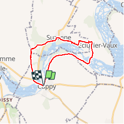
Tour Wandern von 11,2 km verfügbar auf Nordfrankreich, Somme, Cappy. Diese Tour wird von tracegps vorgeschlagen.
Beschreibung
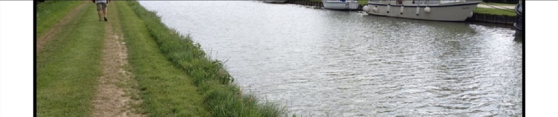
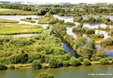
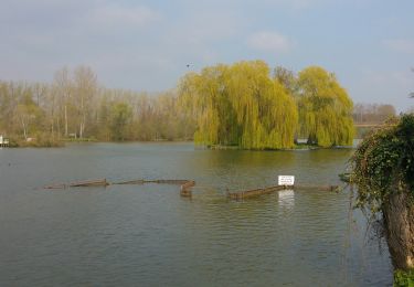
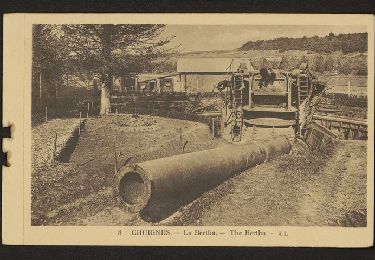
La fête de l'Anguille réunit toutes les années paires les pêcheurs et les chasseurs à Eclusier-Vaux. En attendant, montez au Belvédère pour observer les anguillères.....
Ort
Land:
France
Region :
Nordfrankreich
Abteilung/Provinz :
Somme
Kommune :
Cappy
Standort:
Unknown
Gehen Sie:(Dec)
Gehen Sie:(UTM)
482443 ; 5530611 (31U) N.
Kommentare
Touren in der Umgebung
![Tour Wandern Frise - La Montagne de Frise - Photo](https://media.geolcdn.com/t/375/260/ext.jpg?maxdim=2&url=https%3A%2F%2Fservices.sitytrail.com%2FGeolivesWS%2FDownloadMedia.ashx%3FTrailID%3D191478%26Media%3D15070_3.jpg)
![Wandern Wandern](https://static1.geolcdn.com/sitytour/trail-icons/101.png)
La Montagne de Frise
Wandern
Medium
(1)
Frise,
Nordfrankreich,
Somme,
France
![](/images/other/stat-length.png)
2,2 km | 2,8 km-effort
49min
![](https://static1.geolcdn.com/siteimages/upload/files/16400158638029165_repeat_loop_refresh_sync_direction_icon.png)
Ja
![Tour Zu Fuß Cappy - Les Royards - Photo](https://media.geolcdn.com/t/375/260/61c5a7bb-5adb-45c2-89f4-300458b09b65.jpeg&format=jpg&maxdim=2)
![Zu Fuß Zu Fuß](https://static1.geolcdn.com/sitytour/trail-icons/100.png)
![Tour Wandern Curlu - tour des étangs de curlu - Photo](https://media.geolcdn.com/t/375/260/2b57625a-664a-4009-9f8e-b4056a815ff7.jpg&format=jpg&maxdim=2)
![Wandern Wandern](https://static1.geolcdn.com/sitytour/trail-icons/101.png)
tour des étangs de curlu
Wandern
Sehr leicht
Curlu,
Nordfrankreich,
Somme,
France
![](/images/other/stat-length.png)
10,5 km | 11,6 km-effort
2h 41min
![](https://static1.geolcdn.com/siteimages/upload/files/16400158638029165_repeat_loop_refresh_sync_direction_icon.png)
Ja
![Tour Wandern Curlu - Autour des étangs de Curlu et Feuillères - Photo](https://media.geolcdn.com/t/375/260/ext.jpg?maxdim=2&url=https%3A%2F%2Fservices.sitytrail.com%2FGeolivesWS%2FDownloadMedia.ashx%3FTrailID%3D991523%26Media%3Dfix__20180622190908.jpg)
![Wandern Wandern](https://static1.geolcdn.com/sitytour/trail-icons/101.png)
Autour des étangs de Curlu et Feuillères
Wandern
Einfach
(1)
Curlu,
Nordfrankreich,
Somme,
France
![](/images/other/stat-length.png)
11,6 km | 12,7 km-effort
3h 11min
![](https://static1.geolcdn.com/siteimages/upload/files/16400158638029165_repeat_loop_refresh_sync_direction_icon.png)
Ja
![Tour Andere Aktivitäten Éclusier-Vaux - Vaux - Marais de la Somme - Photo](https://media.geolcdn.com/t/375/260/ext.jpg?maxdim=2&url=https%3A%2F%2Fservices.sitytrail.com%2FGeolivesWS%2FDownloadMedia.ashx%3FTrailID%3D697712%26Media%3D20170213172513.jpg)
![Andere Aktivitäten Andere Aktivitäten](https://static1.geolcdn.com/sitytour/trail-icons/900.png)
Vaux - Marais de la Somme
Andere Aktivitäten
Sehr leicht
Éclusier-Vaux,
Nordfrankreich,
Somme,
France
![](/images/other/stat-length.png)
8,7 km | 10,1 km-effort
2h 13min
![](https://static1.geolcdn.com/siteimages/upload/files/16400158638029165_repeat_loop_refresh_sync_direction_icon.png)
Ja
![Tour Wandern Cappy - Les Champs Muraine - Cappy - Photo](https://media.geolcdn.com/t/375/260/ext.jpg?maxdim=2&url=https%3A%2F%2Fservices.sitytrail.com%2FGeolivesWS%2FDownloadMedia.ashx%3FTrailID%3D316902%26Media%3D15996_1.jpg)
![Wandern Wandern](https://static1.geolcdn.com/sitytour/trail-icons/101.png)
Les Champs Muraine - Cappy
Wandern
Medium
Cappy,
Nordfrankreich,
Somme,
France
![](/images/other/stat-length.png)
9,9 km | 11,9 km-effort
2h 15min
![](https://static1.geolcdn.com/siteimages/upload/files/16400158638029165_repeat_loop_refresh_sync_direction_icon.png)
Ja
![Tour Wandern Frise - montagne de frise - Photo](https://media.geolcdn.com/t/375/260/ext.jpg?maxdim=2&url=https%3A%2F%2Fstatic1.geolcdn.com%2Fsiteimages%2Fupload%2Ffiles%2F1553511878bg_sport_marche.png)
![Wandern Wandern](https://static1.geolcdn.com/sitytour/trail-icons/101.png)
montagne de frise
Wandern
Medium
(1)
Frise,
Nordfrankreich,
Somme,
France
![](/images/other/stat-length.png)
2 km | 2,5 km-effort
1h 0min
![](https://static1.geolcdn.com/siteimages/upload/files/16400158638029165_repeat_loop_refresh_sync_direction_icon.png)
Ja
![Tour Wandern Curlu - Le chemin des Automitrailleuses - Curlu - Photo](https://media.geolcdn.com/t/375/260/ext.jpg?maxdim=2&url=https%3A%2F%2Fservices.sitytrail.com%2FGeolivesWS%2FDownloadMedia.ashx%3FTrailID%3D172267%26Media%3D13579_6.jpg)
![Wandern Wandern](https://static1.geolcdn.com/sitytour/trail-icons/101.png)
Le chemin des Automitrailleuses - Curlu
Wandern
Medium
(1)
Curlu,
Nordfrankreich,
Somme,
France
![](/images/other/stat-length.png)
11 km | 12 km-effort
3h 19min
![](https://static1.geolcdn.com/siteimages/upload/files/16400158638029165_repeat_loop_refresh_sync_direction_icon.png)
Ja
![Tour Wandern Chuignolles - CHUIGNOLLES - 80 Circuit du gros canon - Photo](https://media.geolcdn.com/t/375/260/9b9d871f-5b11-44ae-ade1-6d8bca7d07de.jpg&format=jpg&maxdim=2)
![Wandern Wandern](https://static1.geolcdn.com/sitytour/trail-icons/101.png)
CHUIGNOLLES - 80 Circuit du gros canon
Wandern
Medium
Chuignolles,
Nordfrankreich,
Somme,
France
![](/images/other/stat-length.png)
9,3 km | 11,2 km-effort
2h 33min
![](https://static1.geolcdn.com/siteimages/upload/files/16400158638029165_repeat_loop_refresh_sync_direction_icon.png)
Ja
agréable petite randonnée attention au Bois Fauvel le sentier est barré.