![](/images/other/stat-length.png)
![Tour Wandern Valencisse - Circuit n°3 de Molineuf - Photo](https://media.geolcdn.com/t/1900/400/ext.pjpeg?maxdim=2&url=https%3A%2F%2Fservices.sitytrail.com%2FGeolivesWS%2FDownloadMedia.ashx%3FTrailID%3D317924%26Media%3D17342_5.jpg)
Circuit n°3 de Molineuf
tracegps
Benutzer
![Länge](/images/other/stat-length.png)
Länge
12,3 km
![Maximale Höhe](https://static1.geolcdn.com/siteimages/upload/files/1508320355ic_sort_altitude_max_24dp.png)
Maximale Höhe
137 m
![Positive Höhendifferenz](https://static1.geolcdn.com/siteimages/upload/files/1508320355ic_sort_den_pos_24dp.png)
Positive Höhendifferenz
174 m
![Km-Effort](/images/other/stat-length.png)
Km-Effort
14,6 km
![Min. Höhe](https://static1.geolcdn.com/siteimages/upload/files/1508320355ic_sort_altitude_min_24dp.png)
Min. Höhe
73 m
![Negative Höhendifferenz](https://static1.geolcdn.com/siteimages/upload/files/1508320355ic_sort_den_neg_24dp.png)
Negative Höhendifferenz
173 m
![Boucle](https://static1.geolcdn.com/siteimages/upload/files/16400158638029165_repeat_loop_refresh_sync_direction_icon.png)
Boucle
Ja
Erstellungsdatum :
2014-12-10 00:00:00.0
Letzte Änderung :
2014-12-10 00:00:00.0
![Wandern](https://static1.geolcdn.com/sitytour/trail-icons/101.png)
3h00
Schwierigkeit : Medium
![Scannen Sie diesen QR-Code, um die Tour in der SityTrail-Anwendung zu öffnen](https://capi.geolives.com/qq0zvz2zws4bq2lad0pu/sitytour/trails/317924/qr.png?size=200)
Kostenlosegpshiking-Anwendung
Über SityTrail
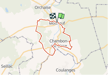
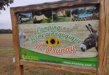
Tour Wandern von 12,3 km verfügbar auf Zentrum-Loiretal, Loir-et-Cher, Valencisse. Diese Tour wird von tracegps vorgeschlagen.
Beschreibung
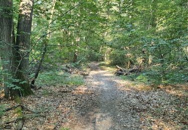
Circuit proposé par l’association de randonnée La Molineuvoise. Départ de la place de la mairie. Le circuit permet de découvrir la partie sud de Molineuf et Chambon-sur-Cisse. Retrouvez le circuit sur le site de La Molineuvoise.
Ort
Land:
France
Region :
Zentrum-Loiretal
Abteilung/Provinz :
Loir-et-Cher
Kommune :
Valencisse
Standort:
Unknown
Gehen Sie:(Dec)
Gehen Sie:(UTM)
365763 ; 5270921 (31T) N.
Kommentare
Touren in der Umgebung
![Tour Wandern Valencisse - Circuit n°4 de Moulineuf - Photo](https://media.geolcdn.com/t/375/260/ext.jpg?maxdim=2&url=https%3A%2F%2Fservices.sitytrail.com%2FGeolivesWS%2FDownloadMedia.ashx%3FTrailID%3D317925%26Media%3D17343_6.jpg)
![Wandern Wandern](https://static1.geolcdn.com/sitytour/trail-icons/101.png)
Circuit n°4 de Moulineuf
Wandern
Medium
(1)
Valencisse,
Zentrum-Loiretal,
Loir-et-Cher,
France
![](/images/other/stat-length.png)
15 km | 18,4 km-effort
3h 45min
![](https://static1.geolcdn.com/siteimages/upload/files/16400158638029165_repeat_loop_refresh_sync_direction_icon.png)
Ja
![Tour Wandern Saint-Sulpice-de-Pommeray - BBR 2025-02-15 Maison forestière Saint-Sulpice 10km - Photo](https://media.geolcdn.com/t/375/260/ext.jpg?maxdim=2&url=https%3A%2F%2Fstatic1.geolcdn.com%2Fsiteimages%2Fupload%2Ffiles%2F1553511878bg_sport_marche.png)
![Wandern Wandern](https://static1.geolcdn.com/sitytour/trail-icons/101.png)
BBR 2025-02-15 Maison forestière Saint-Sulpice 10km
Wandern
Medium
(1)
Saint-Sulpice-de-Pommeray,
Zentrum-Loiretal,
Loir-et-Cher,
France
![](/images/other/stat-length.png)
9,8 km | 11,5 km-effort
2h 36min
![](https://static1.geolcdn.com/siteimages/upload/files/16400158638029165_repeat_loop_refresh_sync_direction_icon.png)
Ja
![Tour Wandern Valencisse - BBR 2025-02-01 Valentine de Milan 10km - Photo](https://media.geolcdn.com/t/375/260/ext.jpg?maxdim=2&url=https%3A%2F%2Fstatic1.geolcdn.com%2Fsiteimages%2Fupload%2Ffiles%2F1553511878bg_sport_marche.png)
![Wandern Wandern](https://static1.geolcdn.com/sitytour/trail-icons/101.png)
BBR 2025-02-01 Valentine de Milan 10km
Wandern
Medium
(1)
Valencisse,
Zentrum-Loiretal,
Loir-et-Cher,
France
![](/images/other/stat-length.png)
10,7 km | 12 km-effort
1h 35min
![](https://static1.geolcdn.com/siteimages/upload/files/16400158638029165_repeat_loop_refresh_sync_direction_icon.png)
Ja
![Tour Zu Fuß Valencisse - Chambon-Molineuf par Champigny - Photo](https://media.geolcdn.com/t/375/260/ext.jpg?maxdim=2&url=https%3A%2F%2Fstatic1.geolcdn.com%2Fsiteimages%2Fupload%2Ffiles%2F1545311037marcheuse_200dpi.jpg)
![Zu Fuß Zu Fuß](https://static1.geolcdn.com/sitytour/trail-icons/100.png)
Chambon-Molineuf par Champigny
Zu Fuß
Einfach
(1)
Valencisse,
Zentrum-Loiretal,
Loir-et-Cher,
France
![](/images/other/stat-length.png)
14,7 km | 18,1 km-effort
Unbekannt
![](https://static1.geolcdn.com/siteimages/upload/files/16400158638029165_repeat_loop_refresh_sync_direction_icon.png)
Ja
![Tour Wandern Valencisse - les rinceaux - Photo](https://media.geolcdn.com/t/375/260/5ccb405d-d4f6-4381-9494-3cfd59f9f42e.jpg&format=jpg&maxdim=2)
![Wandern Wandern](https://static1.geolcdn.com/sitytour/trail-icons/101.png)
les rinceaux
Wandern
Medium
Valencisse,
Zentrum-Loiretal,
Loir-et-Cher,
France
![](/images/other/stat-length.png)
9,1 km | 10,8 km-effort
3h 13min
![](https://static1.geolcdn.com/siteimages/upload/files/16400158638029165_repeat_loop_refresh_sync_direction_icon.png)
Ja
![Tour Wandern Valloire-sur-Cisse - Seillac - Circuit des Bois - Photo](https://media.geolcdn.com/t/375/260/cb29fe41-8850-4ca3-9dd7-41f7208eec6f.jpg&format=jpg&maxdim=2)
![Wandern Wandern](https://static1.geolcdn.com/sitytour/trail-icons/101.png)
Seillac - Circuit des Bois
Wandern
Einfach
Valloire-sur-Cisse,
Zentrum-Loiretal,
Loir-et-Cher,
France
![](/images/other/stat-length.png)
7,8 km | 8,6 km-effort
1h 53min
![](https://static1.geolcdn.com/siteimages/upload/files/16400158638029165_repeat_loop_refresh_sync_direction_icon.png)
Ja
![Tour Wandern Saint-Sulpice-de-Pommeray - Saint-Sulpice-de-Pommeray - Photo](https://media.geolcdn.com/t/375/260/9d1ec0a7-eadc-4416-a6d9-fa4cc5a06fea.jpg&format=jpg&maxdim=2)
![Wandern Wandern](https://static1.geolcdn.com/sitytour/trail-icons/101.png)
Saint-Sulpice-de-Pommeray
Wandern
Medium
Saint-Sulpice-de-Pommeray,
Zentrum-Loiretal,
Loir-et-Cher,
France
![](/images/other/stat-length.png)
24 km | 29 km-effort
8h 41min
![](https://static1.geolcdn.com/siteimages/upload/files/16400158638029165_repeat_loop_refresh_sync_direction_icon.png)
Ja
![Tour Wandern Valloire-sur-Cisse - Randonnée BBR du 18 novembre 2020 - Photo](https://media.geolcdn.com/t/375/260/d5721fd4-941b-4b90-8a20-e6d5dc2dbd16.jpg&format=jpg&maxdim=2)
![Wandern Wandern](https://static1.geolcdn.com/sitytour/trail-icons/101.png)
Randonnée BBR du 18 novembre 2020
Wandern
Sehr leicht
Valloire-sur-Cisse,
Zentrum-Loiretal,
Loir-et-Cher,
France
![](/images/other/stat-length.png)
13,8 km | 15,5 km-effort
2h 50min
![](https://static1.geolcdn.com/siteimages/upload/files/16400158638029165_repeat_loop_refresh_sync_direction_icon.png)
Ja
![Tour Wandern Valencisse - Circuit n°2 de Molineuf - Photo](https://media.geolcdn.com/t/375/260/ext.jpg?maxdim=2&url=https%3A%2F%2Fservices.sitytrail.com%2FGeolivesWS%2FDownloadMedia.ashx%3FTrailID%3D317923%26Media%3D17341_6.jpg)
![Wandern Wandern](https://static1.geolcdn.com/sitytour/trail-icons/101.png)
Circuit n°2 de Molineuf
Wandern
Medium
Valencisse,
Zentrum-Loiretal,
Loir-et-Cher,
France
![](/images/other/stat-length.png)
9 km | 11,6 km-effort
2h 45min
![](https://static1.geolcdn.com/siteimages/upload/files/16400158638029165_repeat_loop_refresh_sync_direction_icon.png)
Ja