![](/images/other/stat-length.png)
![Tour Mountainbike Font-Romeu-Odeillo-Via - FFC Capcir Haut Conflent Circuit 34 Pic des Mauroux - Photo](https://media.geolcdn.com/t/1900/400/ext.pjpeg?maxdim=2&url=https%3A%2F%2Fservices.sitytrail.com%2FGeolivesWS%2FDownloadMedia.ashx%3FTrailID%3D317323%26Media%3D16531_1.jpg)
FFC Capcir Haut Conflent Circuit 34 Pic des Mauroux
tracegps
Benutzer
![Länge](/images/other/stat-length.png)
Länge
19,8 km
![Maximale Höhe](https://static1.geolcdn.com/siteimages/upload/files/1508320355ic_sort_altitude_max_24dp.png)
Maximale Höhe
2135 m
![Positive Höhendifferenz](https://static1.geolcdn.com/siteimages/upload/files/1508320355ic_sort_den_pos_24dp.png)
Positive Höhendifferenz
525 m
![Km-Effort](/images/other/stat-length.png)
Km-Effort
27 km
![Min. Höhe](https://static1.geolcdn.com/siteimages/upload/files/1508320355ic_sort_altitude_min_24dp.png)
Min. Höhe
1757 m
![Negative Höhendifferenz](https://static1.geolcdn.com/siteimages/upload/files/1508320355ic_sort_den_neg_24dp.png)
Negative Höhendifferenz
527 m
![Boucle](https://static1.geolcdn.com/siteimages/upload/files/16400158638029165_repeat_loop_refresh_sync_direction_icon.png)
Boucle
Ja
Erstellungsdatum :
2014-12-10 00:00:00.0
Letzte Änderung :
2014-12-10 00:00:00.0
![Mountainbike](https://static1.geolcdn.com/sitytour/trail-icons/202.png)
3h00
Schwierigkeit : Schwierig
![Scannen Sie diesen QR-Code, um die Tour in der SityTrail-Anwendung zu öffnen](https://capi.geolives.com/qq0zvz2zws4bq2lad0pu/sitytour/trails/317323/qr.png?size=200)
Kostenlosegpshiking-Anwendung
Über SityTrail
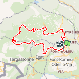
Tour Mountainbike von 19,8 km verfügbar auf Okzitanien, Ostpyrenäen, Font-Romeu-Odeillo-Via. Diese Tour wird von tracegps vorgeschlagen.
Beschreibung
Il s'agit de l' ancien circuit n°11 - maintenant le n° 34 avec certains changements qui n'étaient pas mis à jour par la FFC. Circuit très roulant jusqu’au Pic de Mauroux puis en descente un peu plus difficile techniquement.
Ort
Land:
France
Region :
Okzitanien
Abteilung/Provinz :
Ostpyrenäen
Kommune :
Font-Romeu-Odeillo-Via
Standort:
Unknown
Gehen Sie:(Dec)
Gehen Sie:(UTM)
421390 ; 4706432 (31T) N.
Kommentare
Touren in der Umgebung
![Tour Wandern Font-Romeu-Odeillo-Via - Coll del Pam lac des Bouillouses - Photo](https://media.geolcdn.com/t/375/260/ext.jpg?maxdim=2&url=https%3A%2F%2Fservices.sitytrail.com%2FGeolivesWS%2FDownloadMedia.ashx%3FTrailID%3D802013%26Media%3Dfix__20170803141713.jpg)
![Wandern Wandern](https://static1.geolcdn.com/sitytour/trail-icons/101.png)
Coll del Pam lac des Bouillouses
Wandern
Medium
(2)
Font-Romeu-Odeillo-Via,
Okzitanien,
Ostpyrenäen,
France
![](/images/other/stat-length.png)
13,3 km | 19,3 km-effort
4h 10min
![](https://static1.geolcdn.com/siteimages/upload/files/16400158638029165_repeat_loop_refresh_sync_direction_icon.png)
Ja
![Tour Wandern Eyne - Eyne,col de Nuria,pic d'Eyne,Torre d'Eyne,Eyne. - Photo](https://media.geolcdn.com/t/375/260/ext.jpg?maxdim=2&url=https%3A%2F%2Fservices.sitytrail.com%2FGeolivesWS%2FDownloadMedia.ashx%3FTrailID%3D530520%26Media%3D20150811115220.jpg)
![Wandern Wandern](https://static1.geolcdn.com/sitytour/trail-icons/101.png)
Eyne,col de Nuria,pic d'Eyne,Torre d'Eyne,Eyne.
Wandern
Sehr schwierig
(1)
Eyne,
Okzitanien,
Ostpyrenäen,
France
![](/images/other/stat-length.png)
24 km | 43 km-effort
8h 44min
![](https://static1.geolcdn.com/siteimages/upload/files/16400158638029165_repeat_loop_refresh_sync_direction_icon.png)
Ja
![Tour Schneeschuhwandern Font-Romeu-Odeillo-Via - pic dels moros - Photo](https://media.geolcdn.com/t/375/260/ext.jpg?maxdim=2&url=https%3A%2F%2Fservices.sitytrail.com%2FGeolivesWS%2FDownloadMedia.ashx%3FTrailID%3D509986%26Media%3Dfix__20140323122816.jpg)
![Schneeschuhwandern Schneeschuhwandern](https://static1.geolcdn.com/sitytour/trail-icons/504.png)
pic dels moros
Schneeschuhwandern
Medium
(1)
Font-Romeu-Odeillo-Via,
Okzitanien,
Ostpyrenäen,
France
![](/images/other/stat-length.png)
12,6 km | 19,4 km-effort
4h 46min
![](https://static1.geolcdn.com/siteimages/upload/files/16400158638029165_repeat_loop_refresh_sync_direction_icon.png)
Ja
![Tour Wandern Font-Romeu-Odeillo-Via - Font Romeu Egat - Photo](https://media.geolcdn.com/t/375/260/ext.jpg?maxdim=2&url=https%3A%2F%2Fservices.sitytrail.com%2FGeolivesWS%2FDownloadMedia.ashx%3FTrailID%3D555215%26Media%3D20160418074519.jpg)
![Wandern Wandern](https://static1.geolcdn.com/sitytour/trail-icons/101.png)
Font Romeu Egat
Wandern
Medium
(2)
Font-Romeu-Odeillo-Via,
Okzitanien,
Ostpyrenäen,
France
![](/images/other/stat-length.png)
2,5 km | 3,4 km-effort
44min
![](https://static1.geolcdn.com/siteimages/upload/files/16400158638029165_repeat_loop_refresh_sync_direction_icon.png)
Ja
![Tour Schneeschuhwandern Font-Romeu-Odeillo-Via - Pic dels Moros avec Pierre - Photo](https://media.geolcdn.com/t/375/260/ext.jpg?maxdim=2&url=https%3A%2F%2Fservices.sitytrail.com%2FGeolivesWS%2FDownloadMedia.ashx%3FTrailID%3D542171%26Media%3Dfix__20160322124727.jpg)
![Schneeschuhwandern Schneeschuhwandern](https://static1.geolcdn.com/sitytour/trail-icons/504.png)
Pic dels Moros avec Pierre
Schneeschuhwandern
Medium
(1)
Font-Romeu-Odeillo-Via,
Okzitanien,
Ostpyrenäen,
France
![](/images/other/stat-length.png)
10,5 km | 15,9 km-effort
4h 4min
![](https://static1.geolcdn.com/siteimages/upload/files/16400158638029165_repeat_loop_refresh_sync_direction_icon.png)
Ja
![Tour Wandern Égat - Egat Puig Moro - Photo](https://media.geolcdn.com/t/375/260/ext.jpg?maxdim=2&url=https%3A%2F%2Fservices.sitytrail.com%2FGeolivesWS%2FDownloadMedia.ashx%3FTrailID%3D460362%26Media%3Dfix__20150817141649.jpg)
![Wandern Wandern](https://static1.geolcdn.com/sitytour/trail-icons/101.png)
Egat Puig Moro
Wandern
Medium
(1)
Égat,
Okzitanien,
Ostpyrenäen,
France
![](/images/other/stat-length.png)
13,4 km | 19,3 km-effort
4h 51min
![](https://static1.geolcdn.com/siteimages/upload/files/16400158638029165_repeat_loop_refresh_sync_direction_icon.png)
Ja
![Tour Wandern Égat - La croix d'Egat - Photo](https://media.geolcdn.com/t/375/260/ext.jpg?maxdim=2&url=https%3A%2F%2Fservices.sitytrail.com%2FGeolivesWS%2FDownloadMedia.ashx%3FTrailID%3D143230%26Media%3D20120803102022.jpeg)
![Wandern Wandern](https://static1.geolcdn.com/sitytour/trail-icons/101.png)
La croix d'Egat
Wandern
Einfach
(1)
Égat,
Okzitanien,
Ostpyrenäen,
France
![](/images/other/stat-length.png)
7,1 km | 10,4 km-effort
2h 2min
![](https://static1.geolcdn.com/siteimages/upload/files/16400158638029165_repeat_loop_refresh_sync_direction_icon.png)
Ja
![Tour Wandern Égat - Le Pic dels Moros - Photo](https://media.geolcdn.com/t/375/260/ext.jpg?maxdim=2&url=https%3A%2F%2Fservices.sitytrail.com%2FGeolivesWS%2FDownloadMedia.ashx%3FTrailID%3D108942%26Media%3D2804_1.jpg)
![Wandern Wandern](https://static1.geolcdn.com/sitytour/trail-icons/101.png)
Le Pic dels Moros
Wandern
Schwierig
(2)
Égat,
Okzitanien,
Ostpyrenäen,
France
![](/images/other/stat-length.png)
12,1 km | 18,8 km-effort
5h 30min
![](https://static1.geolcdn.com/siteimages/upload/files/16400158638029165_repeat_loop_refresh_sync_direction_icon.png)
Ja
![Tour Wandern Eyne - Le Cambre d'Ase - Photo](https://media.geolcdn.com/t/375/260/ext.jpg?maxdim=2&url=https%3A%2F%2Fservices.sitytrail.com%2FGeolivesWS%2FDownloadMedia.ashx%3FTrailID%3D102891%26Media%3D4141_2.jpg)
![Wandern Wandern](https://static1.geolcdn.com/sitytour/trail-icons/101.png)
Le Cambre d'Ase
Wandern
Schwierig
(1)
Eyne,
Okzitanien,
Ostpyrenäen,
France
![](/images/other/stat-length.png)
8,9 km | 22 km-effort
4h 0min
![](https://static1.geolcdn.com/siteimages/upload/files/16400158638029165_repeat_loop_refresh_sync_direction_icon.png)
Ja
les angles 4