![](/images/other/stat-length.png)
![Tour Wandern Saint-Laurent-des-Arbres - Les Vignobles de Lirac - Saint Laurent des Arbres - Photo](https://media.geolcdn.com/t/1900/400/ext.pjpeg?maxdim=2&url=https%3A%2F%2Fservices.sitytrail.com%2FGeolivesWS%2FDownloadMedia.ashx%3FTrailID%3D317237%26Media%3D16416_6.jpg)
Les Vignobles de Lirac - Saint Laurent des Arbres
tracegps
Benutzer
![Länge](/images/other/stat-length.png)
![Maximale Höhe](https://static1.geolcdn.com/siteimages/upload/files/1508320355ic_sort_altitude_max_24dp.png)
![Positive Höhendifferenz](https://static1.geolcdn.com/siteimages/upload/files/1508320355ic_sort_den_pos_24dp.png)
![Km-Effort](/images/other/stat-length.png)
![Min. Höhe](https://static1.geolcdn.com/siteimages/upload/files/1508320355ic_sort_altitude_min_24dp.png)
![Negative Höhendifferenz](https://static1.geolcdn.com/siteimages/upload/files/1508320355ic_sort_den_neg_24dp.png)
![Boucle](https://static1.geolcdn.com/siteimages/upload/files/16400158638029165_repeat_loop_refresh_sync_direction_icon.png)
![Wandern](https://static1.geolcdn.com/sitytour/trail-icons/101.png)
4h30
Schwierigkeit : Schwierig
![Scannen Sie diesen QR-Code, um die Tour in der SityTrail-Anwendung zu öffnen](https://capi.geolives.com/qq0zvz2zws4bq2lad0pu/sitytour/trails/317237/qr.png?size=200)
Kostenlosegpshiking-Anwendung
Über SityTrail
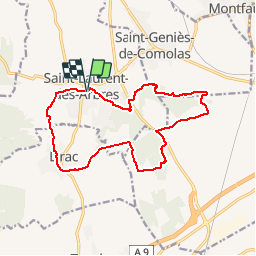
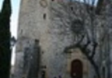
Tour Wandern von 15,4 km verfügbar auf Okzitanien, Gard, Saint-Laurent-des-Arbres. Diese Tour wird von tracegps vorgeschlagen.
Beschreibung
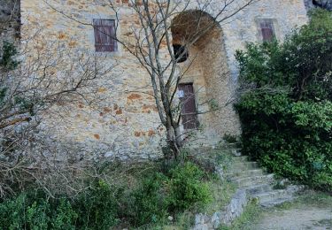
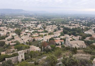
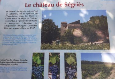
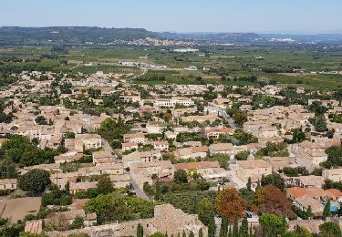
Parking à l'aire de jeux. Aller visiter le village et en sortir par la rue Marcel Pagnol puis le chemin de la Montagnette. La vue se dégage sur la vallée du Rhône et le Ventoux. Traverser Lirac puis remonter et traverser son vignoble avant de passer a la Croix des Gardes. Attention à la traversée de la N580 où l'on retrouve le GR qui nous guide parmi le vignoble. Le quitter pour gagner la montagne de Saint-Génies d'où la vue est splendide tout le long de la crête. Retourner au parking par le Sablas et le Moulin Neuf. Belle rando !
Ort
Kommentare
Touren in der Umgebung
![Tour Wandern Lirac - rando des 4 lavoirs - Photo](https://media.geolcdn.com/t/375/260/b910313b-f40e-420b-9ddd-36236b127dfb.jpg&format=jpg&maxdim=2)
![Wandern Wandern](https://static1.geolcdn.com/sitytour/trail-icons/101.png)
![Tour Wandern Saint-Victor-la-Coste - Saint victor la coste 300323 - Photo](https://media.geolcdn.com/t/375/260/b12b695c-7275-4742-bf11-008804646dd6.jpg&format=jpg&maxdim=2)
![Wandern Wandern](https://static1.geolcdn.com/sitytour/trail-icons/101.png)
Wandern
![](/images/other/stat-length.png)
![](https://static1.geolcdn.com/siteimages/upload/files/16400158638029165_repeat_loop_refresh_sync_direction_icon.png)
![Tour Wandern Lirac - Le Tanargue - Photo](https://media.geolcdn.com/t/375/260/c76d9f19-ee2b-4749-87df-9221a92da648.jpg&format=jpg&maxdim=2)
![Wandern Wandern](https://static1.geolcdn.com/sitytour/trail-icons/101.png)
![Tour Wandern Saint-Victor-la-Coste - St Victor la Coste Goule de Navet - Photo](https://media.geolcdn.com/t/375/260/4895cb47-8177-4f48-bef5-74ca2af99397.jpg&format=jpg&maxdim=2)
![Wandern Wandern](https://static1.geolcdn.com/sitytour/trail-icons/101.png)
Wandern
![](/images/other/stat-length.png)
![](https://static1.geolcdn.com/siteimages/upload/files/16400158638029165_repeat_loop_refresh_sync_direction_icon.png)
![Tour Wandern Saint-Laurent-des-Arbres - St Laurent des Arbres Montagne St Genies - Photo](https://media.geolcdn.com/t/375/260/87789e4e-a0b1-4843-8d74-95689b72d29e.jpg&format=jpg&maxdim=2)
![Wandern Wandern](https://static1.geolcdn.com/sitytour/trail-icons/101.png)
Wandern
![](/images/other/stat-length.png)
![](https://static1.geolcdn.com/siteimages/upload/files/16400158638029165_repeat_loop_refresh_sync_direction_icon.png)
![Tour Wandern Saint-Victor-la-Coste - Le Castellas de Saint Victor - Photo](https://media.geolcdn.com/t/375/260/ext.jpg?maxdim=2&url=https%3A%2F%2Fservices.sitytrail.com%2FGeolivesWS%2FDownloadMedia.ashx%3FTrailID%3D1040678%26Media%3Dfix__20180915142954.jpg)
![Wandern Wandern](https://static1.geolcdn.com/sitytour/trail-icons/101.png)
Wandern
![](/images/other/stat-length.png)
![](https://static1.geolcdn.com/siteimages/upload/files/16400158638029165_repeat_loop_refresh_sync_direction_icon.png)
![Tour Wandern Saint-Victor-la-Coste - Le Goule de Navet - St Victor la Coste - Photo](https://media.geolcdn.com/t/375/260/ext.jpg?maxdim=2&url=https%3A%2F%2Fservices.sitytrail.com%2FGeolivesWS%2FDownloadMedia.ashx%3FTrailID%3D317466%26Media%3D16701_6.jpg)
![Wandern Wandern](https://static1.geolcdn.com/sitytour/trail-icons/101.png)
Wandern
![](/images/other/stat-length.png)
![](https://static1.geolcdn.com/siteimages/upload/files/16400158638029165_repeat_loop_refresh_sync_direction_icon.png)
![Tour Wandern Saint-Victor-la-Coste - 30 - SAINT-VICTOR-LA-COSTE – NAVET - 13.6Km - 05h15 - D 340 m - Photo](https://media.geolcdn.com/t/375/260/ext.jpg?maxdim=2&url=https%3A%2F%2Fstatic1.geolcdn.com%2Fsiteimages%2Fupload%2Ffiles%2F1553511878bg_sport_marche.png)
![Wandern Wandern](https://static1.geolcdn.com/sitytour/trail-icons/101.png)
Wandern
![](/images/other/stat-length.png)
![](https://static1.geolcdn.com/siteimages/upload/files/16400158638029165_repeat_loop_refresh_sync_direction_icon.png)
![Tour Wandern Lirac - Lirac les 4 lavoirs - Photo](https://media.geolcdn.com/t/375/260/ab649616-d1f9-4afb-8474-39fcd12a40eb.jpg&format=jpg&maxdim=2)
![Wandern Wandern](https://static1.geolcdn.com/sitytour/trail-icons/101.png)
Wandern
![](/images/other/stat-length.png)
![](https://static1.geolcdn.com/siteimages/upload/files/16400158638029165_repeat_loop_refresh_sync_direction_icon.png)
Quelques parties dans les vignes dont clôturées, mais globalement le parcours est très agréable.