![](/images/other/stat-length.png)
![Tour Wandern Saizerais - La Cense St Paul - Saizerais - Photo](https://media.geolcdn.com/t/1900/400/ext.pjpeg?maxdim=2&url=https%3A%2F%2Fservices.sitytrail.com%2FGeolivesWS%2FDownloadMedia.ashx%3FTrailID%3D317063%26Media%3D16212_1.jpg)
La Cense St Paul - Saizerais
tracegps
Benutzer
![Länge](/images/other/stat-length.png)
![Maximale Höhe](https://static1.geolcdn.com/siteimages/upload/files/1508320355ic_sort_altitude_max_24dp.png)
![Positive Höhendifferenz](https://static1.geolcdn.com/siteimages/upload/files/1508320355ic_sort_den_pos_24dp.png)
![Km-Effort](/images/other/stat-length.png)
![Min. Höhe](https://static1.geolcdn.com/siteimages/upload/files/1508320355ic_sort_altitude_min_24dp.png)
![Negative Höhendifferenz](https://static1.geolcdn.com/siteimages/upload/files/1508320355ic_sort_den_neg_24dp.png)
![Boucle](https://static1.geolcdn.com/siteimages/upload/files/16400158638029165_repeat_loop_refresh_sync_direction_icon.png)
![Wandern](https://static1.geolcdn.com/sitytour/trail-icons/101.png)
1h30
Schwierigkeit : Einfach
![Scannen Sie diesen QR-Code, um die Tour in der SityTrail-Anwendung zu öffnen](https://capi.geolives.com/qq0zvz2zws4bq2lad0pu/sitytour/trails/317063/qr.png?size=200)
Kostenlosegpshiking-Anwendung
Über SityTrail
Tour Wandern von 6,2 km verfügbar auf Großer Osten, Mörthe und Mosel, Saizerais. Diese Tour wird von tracegps vorgeschlagen.
Beschreibung
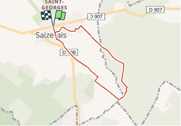
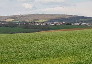
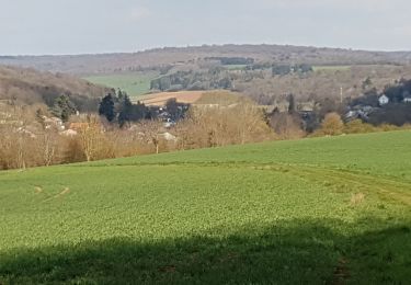
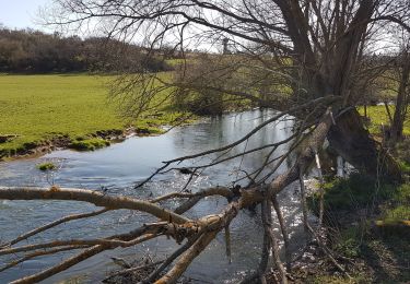
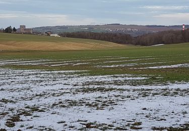
Circuit proposé par OXYGENE et la commune de Saizerais. Situé en bordure du plateau lorrain, non loin du confluent de la Moselle et de la Meurthe, à l'entrée sud du Parc Régional de Lorraine, le village de Saizerais se trouve à proximité de forêts très belles comme la forêt domaniale de Natrou ou la forêt domaniale de l'Avant Garde. Le circuit St Paul réserve de beaux coups d’œil sur le village. Très belle ambiance en été, juste avant les moissons. Retrouvez le plan et descriptif du circuit sur le site de l'association OXYGENE.
Ort
Kommentare
Touren in der Umgebung
![Tour Wandern Liverdun - Liverdun - La grande boucle de Natrou - Photo](https://media.geolcdn.com/t/375/260/5dac390e-3606-42c9-8130-3aab112c0eaf.jpg&format=jpg&maxdim=2)
![Wandern Wandern](https://static1.geolcdn.com/sitytour/trail-icons/101.png)
Wandern
![](/images/other/stat-length.png)
![](https://static1.geolcdn.com/siteimages/upload/files/16400158638029165_repeat_loop_refresh_sync_direction_icon.png)
![Tour Zu Fuß Marbache - Circuit de la Vierge de Belleville - Photo](https://media.geolcdn.com/t/375/260/ed731c2b-3434-456a-907f-b6c3a07468bd.jpeg&format=jpg&maxdim=2)
![Zu Fuß Zu Fuß](https://static1.geolcdn.com/sitytour/trail-icons/100.png)
Zu Fuß
![](/images/other/stat-length.png)
![](https://static1.geolcdn.com/siteimages/upload/files/16400158638029165_repeat_loop_refresh_sync_direction_icon.png)
![Tour Wandern Saizerais - SAIZERAIS - LES CORNOUILLERS ET LES HOSPICES - Photo](https://media.geolcdn.com/t/375/260/54e8a510-a902-4c19-acc7-c2168d7e5db6.jpg&format=jpg&maxdim=2)
![Wandern Wandern](https://static1.geolcdn.com/sitytour/trail-icons/101.png)
Wandern
![](/images/other/stat-length.png)
![](https://static1.geolcdn.com/siteimages/upload/files/16400158638029165_repeat_loop_refresh_sync_direction_icon.png)
![Tour Wandern Rogéville - ROGEVILLE - LA PETITE SUISSE PAR MAMEY ET GEZONCOURT - Photo](https://media.geolcdn.com/t/375/260/9da3ecdf-5552-45ce-a8e5-2bd94b8442b6.jpg&format=jpg&maxdim=2)
![Wandern Wandern](https://static1.geolcdn.com/sitytour/trail-icons/101.png)
Wandern
![](/images/other/stat-length.png)
![](https://static1.geolcdn.com/siteimages/upload/files/16400158638029165_repeat_loop_refresh_sync_direction_icon.png)
![Tour Wandern Dieulouard - DIEULOUARD - VERS BELLEVILLE ET SAIZERAIS - Photo](https://media.geolcdn.com/t/375/260/c2018011-1bfa-47ce-b819-34efd5861339.jpg&format=jpg&maxdim=2)
![Wandern Wandern](https://static1.geolcdn.com/sitytour/trail-icons/101.png)
Wandern
![](/images/other/stat-length.png)
![](https://static1.geolcdn.com/siteimages/upload/files/16400158638029165_repeat_loop_refresh_sync_direction_icon.png)
![Tour Wandern Marbache - MARBACHE - LA TARTE - Photo](https://media.geolcdn.com/t/375/260/c7ab0792-3c24-41a0-b793-e6399a96c4a4.jpg&format=jpg&maxdim=2)
![Wandern Wandern](https://static1.geolcdn.com/sitytour/trail-icons/101.png)
Wandern
![](/images/other/stat-length.png)
![](https://static1.geolcdn.com/siteimages/upload/files/16400158638029165_repeat_loop_refresh_sync_direction_icon.png)
![Tour Wandern Gézoncourt - GEZONCOURT - PETITE SUISSE LORRAINE - Photo](https://media.geolcdn.com/t/375/260/0c868cf4-7521-4b69-b2f6-03625391f5f0.jpg&format=jpg&maxdim=2)
![Wandern Wandern](https://static1.geolcdn.com/sitytour/trail-icons/101.png)
Wandern
![](/images/other/stat-length.png)
![](https://static1.geolcdn.com/siteimages/upload/files/16400158638029165_repeat_loop_refresh_sync_direction_icon.png)
![Tour Wandern Dieulouard - LA VIERGE DE BELLEVILLE - Photo](https://media.geolcdn.com/t/375/260/92071029-0e02-4fd1-a34a-416f4acba2b2.jpg&format=jpg&maxdim=2)
![Wandern Wandern](https://static1.geolcdn.com/sitytour/trail-icons/101.png)
Wandern
![](/images/other/stat-length.png)
![](https://static1.geolcdn.com/siteimages/upload/files/16400158638029165_repeat_loop_refresh_sync_direction_icon.png)
![Tour Wandern Liverdun - foret de Natrou & vallée de la Moselle avec barrage de la Marne au Rhin avec l écluse - Photo](https://media.geolcdn.com/t/375/260/ext.jpg?maxdim=2&url=https%3A%2F%2Fservices.sitytrail.com%2FGeolivesWS%2FDownloadMedia.ashx%3FTrailID%3D688485%26Media%3D20170123164830.jpg)
![Wandern Wandern](https://static1.geolcdn.com/sitytour/trail-icons/101.png)
Wandern
![](/images/other/stat-length.png)
![](https://static1.geolcdn.com/siteimages/upload/files/16400158638029165_repeat_loop_refresh_sync_direction_icon.png)