![](/images/other/stat-length.png)
![Tour Wandern Feigneux - Vez en Automne - Feigneux - Photo](https://media.geolcdn.com/t/1900/400/ext.pjpeg?maxdim=2&url=https%3A%2F%2Fservices.sitytrail.com%2FGeolivesWS%2FDownloadMedia.ashx%3FTrailID%3D317010%26Media%3D16150_5.jpg)
Vez en Automne - Feigneux
tracegps
Benutzer
![Länge](/images/other/stat-length.png)
Länge
26 km
![Maximale Höhe](https://static1.geolcdn.com/siteimages/upload/files/1508320355ic_sort_altitude_max_24dp.png)
Maximale Höhe
176 m
![Positive Höhendifferenz](https://static1.geolcdn.com/siteimages/upload/files/1508320355ic_sort_den_pos_24dp.png)
Positive Höhendifferenz
459 m
![Km-Effort](/images/other/stat-length.png)
Km-Effort
32 km
![Min. Höhe](https://static1.geolcdn.com/siteimages/upload/files/1508320355ic_sort_altitude_min_24dp.png)
Min. Höhe
59 m
![Negative Höhendifferenz](https://static1.geolcdn.com/siteimages/upload/files/1508320355ic_sort_den_neg_24dp.png)
Negative Höhendifferenz
459 m
![Boucle](https://static1.geolcdn.com/siteimages/upload/files/16400158638029165_repeat_loop_refresh_sync_direction_icon.png)
Boucle
Ja
Erstellungsdatum :
2014-12-10 00:00:00.0
Letzte Änderung :
2014-12-10 00:00:00.0
![Wandern](https://static1.geolcdn.com/sitytour/trail-icons/101.png)
5h30
Schwierigkeit : Schwierig
![Scannen Sie diesen QR-Code, um die Tour in der SityTrail-Anwendung zu öffnen](https://capi.geolives.com/qq0zvz2zws4bq2lad0pu/sitytour/trails/317010/qr.png?size=200)
Kostenlosegpshiking-Anwendung
Über SityTrail
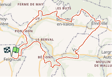
Tour Wandern von 26 km verfügbar auf Nordfrankreich, Oise, Feigneux. Diese Tour wird von tracegps vorgeschlagen.
Beschreibung
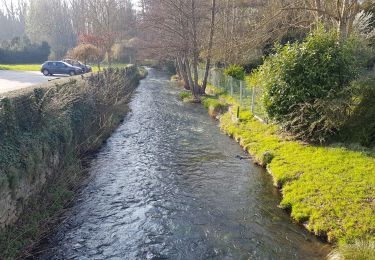
Départ de la mairie de Feigneux. Randonnée en zone souvent boisée, parfois humide le long des vallées. Les chemins sont très praticables. Le village de Vez mérite un détour. La partie sud du circuit se tient sur le GR11 et GR11B.
Ort
Land:
France
Region :
Nordfrankreich
Abteilung/Provinz :
Oise
Kommune :
Feigneux
Standort:
Unknown
Gehen Sie:(Dec)
Gehen Sie:(UTM)
494972 ; 5456298 (31U) N.
Kommentare
Touren in der Umgebung
![Tour Zu Fuß Crépy-en-Valois - Boucle 24 km Crépy en Valois - Duvy - Trumily - Rocquemont - Photo](https://media.geolcdn.com/t/375/260/280ca2ce-af52-47b9-81c4-4fc64d53f4f3.jpg&format=jpg&maxdim=2)
![Zu Fuß Zu Fuß](https://static1.geolcdn.com/sitytour/trail-icons/100.png)
Boucle 24 km Crépy en Valois - Duvy - Trumily - Rocquemont
Zu Fuß
Medium
Crépy-en-Valois,
Nordfrankreich,
Oise,
France
![](/images/other/stat-length.png)
24 km | 27 km-effort
6h 14min
![](https://static1.geolcdn.com/siteimages/upload/files/16400158638029165_repeat_loop_refresh_sync_direction_icon.png)
Ja
![Tour Zu Fuß Morienval - Morienval- Crepy en Valois par la vallée de l'Automne - Photo](https://media.geolcdn.com/t/375/260/535655d5-fe74-49b4-b09d-122bf59c29ec.jpg&format=jpg&maxdim=2)
![Zu Fuß Zu Fuß](https://static1.geolcdn.com/sitytour/trail-icons/100.png)
Morienval- Crepy en Valois par la vallée de l'Automne
Zu Fuß
Schwierig
Morienval,
Nordfrankreich,
Oise,
France
![](/images/other/stat-length.png)
28 km | 35 km-effort
7h 56min
![](https://static1.geolcdn.com/siteimages/upload/files/16400158638029165_repeat_loop_refresh_sync_direction_icon.png)
Nein
![Zu Fuß Zu Fuß](https://static1.geolcdn.com/sitytour/trail-icons/100.png)
le GR11 dans la Forêt de Retz et sur les bords du canal de l'Ourcq
Zu Fuß
Sehr schwierig
Crépy-en-Valois,
Nordfrankreich,
Oise,
France
![](/images/other/stat-length.png)
42 km | 51 km-effort
Unbekannt
![](https://static1.geolcdn.com/siteimages/upload/files/16400158638029165_repeat_loop_refresh_sync_direction_icon.png)
Nein
![Tour Wandern Vauciennes - en forêt de Retz_71_Chavres_carrefour de la Chapelle de Montigny_AR - Photo](https://media.geolcdn.com/t/375/260/ext.jpg?maxdim=2&url=https%3A%2F%2Fservices.sitytrail.com%2FGeolivesWS%2FDownloadMedia.ashx%3FTrailID%3D1051658%26Media%3Db1fc04b4-d99a-4134-8103-c8656945a89e.JPG)
![Wandern Wandern](https://static1.geolcdn.com/sitytour/trail-icons/101.png)
en forêt de Retz_71_Chavres_carrefour de la Chapelle de Montigny_AR
Wandern
Schwierig
Vauciennes,
Nordfrankreich,
Oise,
France
![](/images/other/stat-length.png)
18,6 km | 22 km-effort
6h 10min
![](https://static1.geolcdn.com/siteimages/upload/files/16400158638029165_repeat_loop_refresh_sync_direction_icon.png)
Ja
![Tour Wandern Coyolles - en foret de Retz_ 40_Vaumoise_les bruyères de Gondreville_Chavres_AR - Photo](https://media.geolcdn.com/t/375/260/ext.jpg?maxdim=2&url=https%3A%2F%2Fservices.sitytrail.com%2FGeolivesWS%2FDownloadMedia.ashx%3FTrailID%3D486247%26Media%3D0b6e2815-570a-4c2b-b4bd-477ad8a94849.JPG)
![Wandern Wandern](https://static1.geolcdn.com/sitytour/trail-icons/101.png)
en foret de Retz_ 40_Vaumoise_les bruyères de Gondreville_Chavres_AR
Wandern
Schwierig
Coyolles,
Nordfrankreich,
Aisne,
France
![](/images/other/stat-length.png)
21 km | 24 km-effort
5h 6min
![](https://static1.geolcdn.com/siteimages/upload/files/16400158638029165_repeat_loop_refresh_sync_direction_icon.png)
Ja
![Tour Mountainbike Fresnoy-la-Rivière - Clochers en Vallée de l'Automne (version courte) - Fresnoy-la-Rivière - Photo](https://media.geolcdn.com/t/375/260/ext.jpg?maxdim=2&url=https%3A%2F%2Fservices.sitytrail.com%2FGeolivesWS%2FDownloadMedia.ashx%3FTrailID%3D111167%26Media%3D6606_4.jpg)
![Mountainbike Mountainbike](https://static1.geolcdn.com/sitytour/trail-icons/202.png)
Clochers en Vallée de l'Automne (version courte) - Fresnoy-la-Rivière
Mountainbike
Einfach
Fresnoy-la-Rivière,
Nordfrankreich,
Oise,
France
![](/images/other/stat-length.png)
9 km | 11,7 km-effort
1h 0min
![](https://static1.geolcdn.com/siteimages/upload/files/16400158638029165_repeat_loop_refresh_sync_direction_icon.png)
Ja
![Tour Wandern Fresnoy-la-Rivière - Clochers en Vallée de l'Automne (version courte) - Fresnoy-la-Rivière - Photo](https://media.geolcdn.com/t/375/260/ext.jpg?maxdim=2&url=https%3A%2F%2Fservices.sitytrail.com%2FGeolivesWS%2FDownloadMedia.ashx%3FTrailID%3D111166%26Media%3D6606_4.jpg)
![Wandern Wandern](https://static1.geolcdn.com/sitytour/trail-icons/101.png)
Clochers en Vallée de l'Automne (version courte) - Fresnoy-la-Rivière
Wandern
Medium
(1)
Fresnoy-la-Rivière,
Nordfrankreich,
Oise,
France
![](/images/other/stat-length.png)
9 km | 11,7 km-effort
2h 15min
![](https://static1.geolcdn.com/siteimages/upload/files/16400158638029165_repeat_loop_refresh_sync_direction_icon.png)
Ja
![Tour Motor Crépy-en-Valois - Randoguide - Photo](https://media.geolcdn.com/t/375/260/ext.jpg?maxdim=2&url=https%3A%2F%2Fstatic1.geolcdn.com%2Fsiteimages%2Fupload%2Ffiles%2F15247431544x4.jpg)
![Motor Motor](https://static1.geolcdn.com/sitytour/trail-icons/400.png)
Randoguide
Motor
Medium
(1)
Crépy-en-Valois,
Nordfrankreich,
Oise,
France
![](/images/other/stat-length.png)
64 km | 78 km-effort
5h 26min
![](https://static1.geolcdn.com/siteimages/upload/files/16400158638029165_repeat_loop_refresh_sync_direction_icon.png)
Nein
![Tour Wandern Fresnoy-la-Rivière - Fresnoy-la-Rivière - Photo](https://media.geolcdn.com/t/375/260/5da58e15-7bb1-4b85-b1bf-12a84cc1a557.jpg&format=jpg&maxdim=2)
![Wandern Wandern](https://static1.geolcdn.com/sitytour/trail-icons/101.png)
Fresnoy-la-Rivière
Wandern
Medium
Fresnoy-la-Rivière,
Nordfrankreich,
Oise,
France
![](/images/other/stat-length.png)
10,4 km | 12,1 km-effort
2h 16min
![](https://static1.geolcdn.com/siteimages/upload/files/16400158638029165_repeat_loop_refresh_sync_direction_icon.png)
Ja